Rice, California facts for kids
Quick facts for kids
Rice, California
|
|
|---|---|
| Country | United States |
| State | California |
| County | San Bernardino |
| Elevation | 832 ft (254 m) |
| Population
(2000)
|
|
| • Total | 0 |
| Time zone | UTC-8 (Pacific (PST)) |
| • Summer (DST) | UTC-7 (PDT) |
| GNIS feature ID | 248157 |
Rice, once called Blythe Junction, is a ghost town in southern California. It's located in the Rice Valley at the edge of the Mojave Desert, in San Bernardino County. Even though it still appears on many maps, today you'll only find the famous Rice Shoe Tree and a railroad track where trains can wait. No one lives there anymore, and there are no buildings left standing.
Contents
History of Rice
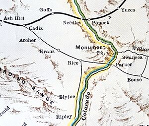
The town of Rice grew up around a railroad line. This line belonged to the Santa Fe Railroad and had a special spot where trains could pull over. Rice is located on what is now California State Route 62, between Twentynine Palms and the Colorado River.
The railroad line is still used today. It is now owned by the Arizona and California Railroad. This shorter railroad line connects southeastern California, from Rice to Cadiz, California, and goes into southwestern Arizona at Parker. Rice was also the starting point for another railroad line that went through Blythe to Ripley, California, but this line is no longer used.
Rice Army Airfield and Airport
East of Rice, there was once an airport called Rice Municipal Airport. The United States Army took it over in 1942. It became a smaller base for Thermal Army Airfield and was ready for use by the end of that year. We don't know exactly when the airport was built. However, it wasn't on a 1932 map, so it must have been built between 1932 and 1942.
Rice Army Airfield had two paved runways, each 5,000 feet long. It also had many areas south of the runways where planes could park. In 1944, the airfield was moved under the control of March Field. Operations at Rice Field stopped by August 1944. The field was then declared extra military property on October 31, 1944.
The desert training area near Rice Army Airfield was once considered for the world's first atomic bomb test. This test was called "Trinity." It was the second choice for the test site. In the end, a different location near Alamogordo, New Mexico, was chosen instead.
The Famous Rice Shoe Tree
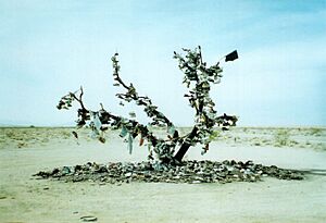
Rice became well-known for its unique Shoe Tree. It started as an "underwear tree." This was a single tamarisk tree located next to the main entrance of the old Rice Army Airfield. A business nearby, which served military personnel, encouraged customers to throw underwear into the tree's branches.
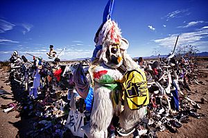
After a fire burned most of the tree and all the underwear, the tradition changed. People started throwing old shoes onto the burned tree trunk. The tree was even featured on California's Gold, a TV show hosted by Huell Howser. In 2003, the tree burned completely to the ground. After that, a "shoe garden" took its place. This is a fence where people hang their shoes.
In early 2016, travelers started throwing shoes onto the roof of Rice's abandoned gas station. People also stop in the area to spell out their names or initials. They use colorful volcanic rocks found along the nearby Arizona and California Railroad tracks. You can see these rock "graffiti" messages along the railroad where it runs next to Highway 62.
Rice Today
Between 1944 and 1948, Rice Army Airfield was renamed Rice Airport. It started operating as a public airport for civilians. It even had a small flight school for people training to be missionaries. Between 1952 and 1955, Rice Airport became a private airfield. By 1960, it was completely abandoned. As of 2007, there are no buildings left standing, and it's hard to find any signs that an airport was ever there.
Today, there are no standing buildings and no people living in Rice. A hand-painted sign on the west side of town once said the town was for sale, but that sign is gone now. The only structure that still remains, though damaged, is an old service station.
Parts of the movie Fast Five were filmed near Rice in 2010. The movie was released the next year. Rice was shown during an exciting train scene at the beginning of the film.
See also
 In Spanish: Rice (California) para niños
 | Frances Mary Albrier |
 | Whitney Young |
 | Muhammad Ali |


