
List of ghost towns in California facts for kids
Have you ever wondered about towns that used to be busy but are now empty? These are called ghost towns. California has many of them, especially from the exciting days of the California Gold Rush and mining booms. A ghost town is a place where most people have left, and buildings are often empty or falling apart. Sometimes, nothing is left at all!

What Makes a Town a Ghost Town?
Ghost towns aren't all the same. They can be classified by how much is left of them:
- Barren sites: These are places where almost nothing is left. The buildings might be gone, covered by water, or the land might have turned back into fields. It's hard to find any signs that a town was once there.
- Neglected sites: Here, you might find some ruins, like buildings without roofs, or just piles of old bricks and wood. It's clear a town was there, but it's very worn down.
- Abandoned sites: In these towns, many buildings are still standing, but they are all empty. You might only find a caretaker living there, or maybe just one or two old buildings like a church or a store.
- Semi-abandoned sites: These towns still have a few people living in them, but many of the buildings are abandoned. They are much quieter than they used to be.
- Historic communities: These places are still active towns, but their population has dropped a lot from their busiest times. They might be only a fifth of their original size or even smaller.
List of California Ghost Towns
Here is a list of some of the ghost towns and former communities in California:
| Town | Other names | County | Latitude/Longitude | Founded | Abandoned | Status | Remarks |
|---|---|---|---|---|---|---|---|
| Agua Fria | Mariposa | 37°29′06″N 120°01′13″W / 37.48500°N 120.02028°W | 1850 | 1862 | Barren | ||
| Agua Mansa | San Bernardino | 34°02′31″N 117°21′50″W / 34.04194°N 117.36389°W | After 1862 | Barren | Slowly declined after the Great Flood of 1862. | ||
| Alma | Lexington | Santa Clara | 37°10′48″N 121°58′48″W / 37.18000°N 121.98000°W | 1952 | Submerged | Alma was taken down for the James J. Lenihan Dam in 1952. Its buildings are now under the Lexington Reservoir and can only be seen when water levels are low. | |
| Amboy | San Bernardino | 34°33′25″N 115°44′42″W / 34.55694°N 115.74500°W | Semi-abandoned | ||||
| Ashford Mill | Inyo | 35°55′08″N 116°41′05″W / 35.91889°N 116.68472°W | 1914 | ||||
| Asphalto | Kern | 35°18′17″N 119°36′03″W / 35.30472°N 119.60083°W | 1900 | ||||
| Atolia | San Bernardino | 35°18′53″N 117°36′33″W / 35.31472°N 117.60917°W | 2007 | ||||
| Avena | Inyo | ||||||
| Bagdad | San Bernardino | 34°34′58″N 115°52′32″W / 34.58278°N 115.87556°W | Barren | ||||
| Ballarat | Inyo | 36°02′52″N 117°13′24″W / 36.04778°N 117.22333°W | The Manson Family left graffiti here. | ||||
| Banta | San Joaquin Valley | San Joaquin | 37°45′16″N 121°22′11″W / 37.75444°N 121.36972°W | ||||
| Barnes Settlement | Kern | ||||||
| Beeks Place | Orange | 33°49′14″N 117°38′20″W / 33.82049°N 117.63878°W | |||||
| Belleville | San Bernardino | 34°18′4″N 116°53′3″W / 34.30111°N 116.88417°W | |||||
| Bennettville | Mono | 37°56′15″N 119°15′38″W / 37.93750°N 119.26056°W | |||||
| Bend City | Inyo | 36°49′09″N 118°07′50″W / 36.81917°N 118.13056°W | |||||
| Benton | Mono | 37°49′09″N 118°28′35″W / 37.81917°N 118.47639°W | |||||
| Bestville | Siskiyou | 41°18′03″N 123°08′35″W / 41.3007°N 123.1431°W | |||||
| Blue Mountain | Calaveras | 38°22′15″N 120°21′59″W / 38.37080°N 120.36642°W | |||||
| Bodie | Mono | 38°12′44″N 119°00′44″W / 38.21222°N 119.01222°W | |||||
| Bondville | Mariposa | ||||||
| Borel | Mariposa | ||||||
| Branson City | San Diego | 33°04′41″N 116°37′02″W / 33.07806°N 116.61722°W | |||||
| Calico | San Bernardino | 34°56′56″N 116°51′51″W / 34.94889°N 116.86417°W | 1881 | ||||
| Camanche | Calaveras | 38°12′48″N 120°56′07″W / 38.21333°N 120.93528°W | |||||
| Camp Spirito | Calaveras | 38°24′39″N 120°31′07″W / 38.41080°N 120.51851°W | |||||
| Canebrake | Kern | 35°43′42″N 118°08′18″W / 35.72833°N 118.13833°W | |||||
| Canon City | Trinity | 40°49′53″N 123°03′10″W / 40.83139°N 123.05278°W | |||||
| Carnegie | San Joaquin | 37°37′46″N 121°31′41″W / 37.62951°N 121.52797°W | |||||
| Carson Hill | Calaveras | 38°01′42″N 120°30′24″W / 38.02833°N 120.50667°W | |||||
| Cement | Solano | 38°17′34″N 121°59′46″W / 38.29278°N 121.99611°W | |||||
| Cerro Gordo | Inyo | 36°32.2626′N 117°47.70186′W / 36.5377100°N 117.79503100°W | |||||
| Cerro Gordo Landing | Inyo | ||||||
| Chambless | San Bernardino | 34°33′41″N 115°32′41″W / 34.56139°N 115.54472°W | |||||
| Chanz | Kern | ||||||
| Cherokee | Butte | 39°38′47″N 121°32′18″W / 39.64639°N 121.53833°W | |||||
| Chinquapin | Mariposa | 37°39′00″N 119°42′19″W / 37.65000°N 119.70528°W | |||||
| China Camp | Marin | 38°00′3″N 122°27′41″W / 38.00083°N 122.46139°W | |||||
| Chinese Camp | Tuolumne | 37°52′13″N 120°26′01″W / 37.87028°N 120.43361°W | |||||
| Chloride City | Inyo | 36°42′24″N 116°52′56″W / 36.70667°N 116.88222°W | |||||
| Chrysopolis | Inyo | 36°57′38″N 118°11′48″W / 36.96056°N 118.19667°W | |||||
| Clarkson | Kern | ||||||
| Clearing House | Clearinghouse, Yosemite Mill | Mariposa | Semi-abandoned | ||||
| Coleman City | San Diego | 33°05′10″N 116°38′42″W / 33.08611°N 116.64500°W | |||||
| Coso | Inyo | 36°10′36″N 117°38′49″W / 36.17667°N 117.64694°W | |||||
| Cox & Clark Trading Post and Steamboat Landing | Kings | 35°58′08″N 119°56′21″W / 35.96898°N 119.93929°W | |||||
| Coyote | Santa Clara | 37°13′00″N 121°44′26″W / 37.21667°N 121.74056°W | |||||
| Craft | Kern | ||||||
| Cuttens | Kern | ||||||
| Cuyamaca City | San Diego | 32°59′05″N 116°34′15″W / 32.98472°N 116.57083°W | |||||
| Darwin | Inyo | 36°16′05″N 117°35′30″W / 36.26806°N 117.59167°W | |||||
| Deadwood | Placer | 39°04′50″N 120°41′22″W / 39.08056°N 120.68944°W | |||||
| Deadwood | Trinity | 40°43′10″N 122°44′01″W / 40.71944°N 122.73361°W | |||||
| Dedrick | Trinity | 40°51′46″N 123°02′12″W / 40.86278°N 123.03667°W | |||||
| Denny | Trinity | 40°56′38″N 123°23′12″W / 40.94389°N 123.38667°W | |||||
| Desert Spring | Kern | 35°16′20″N 118°37′34″W / 35.27222°N 118.62611°W | |||||
| Dogtown | Mono | 38°10′13″N 119°11′51″W / 38.17028°N 119.19750°W | |||||
| Domino | Kern | ||||||
| Doreleska | Trinity | ||||||
| Drawbridge | Alameda | 37°27′54″N 121°58′28″W / 37.46500°N 121.97444°W | |||||
| Drytown | Amador | 38°26′28″N 120°51′16″W / 38.44111°N 120.85444°W | |||||
| Dunmovin | Inyo | 36°05′19″N 117°57′40″W / 36.08861°N 117.96111°W | |||||
| Eagle Mountain | Riverside | 33°51′27″N 115°29′14″W / 33.85750°N 115.48722°W | |||||
| Eastwood | San Diego | 33°05′15″N 116°36′40″W / 33.08750°N 116.61111°W | |||||
| Echo | Inyo | Barren | |||||
| El Dorado Bar | Calaveras | ||||||
| Eldoradoville | Los Angeles | 34°13′47″N 117°46′11″W / 34.2297°N 117.7698°W | 1862 | ||||
| Elliott | San Joaquin | 38°14′05″N 121°10′51″W / 38.23472°N 121.18083°W | 1846 | ||||
| Elna | Inyo | 37°05′38″N 118°13′28″W / 37.09389°N 118.22444°W | |||||
| Empire City | Stanislaus | 37°38.239′N 120°54.167′W / 37.637317°N 120.902783°W | |||||
| Emory | Mariposa | ||||||
| Essex | San Bernardino | 34°44′01″N 115°14′42″W / 34.73361°N 115.24500°W | |||||
| Falk | Humboldt | ||||||
| Fountain Springs | Tulare | 35°53′28″N 118°54′56″W / 35.891111°N 118.915556°W | |||||
| Freeman Junction | Kern | 35°36′06″N 117°54′11″W / 35.60166°N 117.90295°W | |||||
| Fremont Valley | Calaveras | ||||||
| French Flat | Tuolumne | 37°58′20″N 120°28′17″W / 37.97222°N 120.47139°W | |||||
| Furnace | Inyo | 36°11′29″N 116°39′54″W / 36.19133°N 116.66495°W | |||||
| Furnace Creek Inn | Inyo | 36°27′02″N 116°51′08″W / 36.45056°N 116.85222°W | |||||
| Garlock | Kern | 35°24′09″N 117°47′24″W / 35.40250°N 117.79000°W | |||||
| Gas Point | Shasta | 40°24′56″N 122°32′04″W / 40.41556°N 122.53444°W | |||||
| Gibsonville | Sierra | 39°44′25″N 120°54′32″W / 39.74028°N 120.90889°W | |||||
| Girard | Kern | ||||||
| Glenburn | Kern | ||||||
| Goffs | San Bernardino | 34°55′09″N 115°03′46″W / 34.91917°N 115.06278°W | |||||
| Gold Town | Kern | 35°00′06″N 118°10′08″W / 35.00167°N 118.16889°W | |||||
| Goler Heights | Kern | 35°25′37″N 117°44′45″W / 35.42694°N 117.74583°W | |||||
| Greasertown | Calaveras | 38°11′28″N 120°45′15″W / 38.19113°N 120.75407°W | |||||
| Greenwater | Inyo | 36°10′46″N 116°36′59″W / 36.17944°N 116.61639°W | |||||
| Greenwich | Kern | ||||||
| Gerstley | Inyo | 36°00′43″N 116°16′28″W / 36.01190°N 116.27456°W | |||||
| Grub Gulch | Madera | 37°19′29″N 119°46′15″W / 37.32472°N 119.77083°W | |||||
| Gullion's Bar | Siskiyou | 41°17′48″N 123°21′36″W / 41.29667°N 123.36000°W | |||||
| Haiwee | Inyo | 36°08′48″N 117°58′33″W / 36.14667°N 117.97583°W | |||||
| Hamilton | Butte | 39°27′09″N 121°38′28″W / 39.45254°N 121.64108°W | |||||
| Hart | San Bernardino | 35°17′20″N 115°06′12″W / 35.28889°N 115.10333°W | |||||
| Hatfields Camp | Kern | 35°28′26″N 117°52′06″W / 35.47389°N 117.86833°W | |||||
| Helena | Trinity | 40°46′25″N 123°07′42″W / 40.77361°N 123.12833°W | |||||
| Hoboken | Sacramento | 38°33′28″N 121°25′04″W / 38.55778°N 121.41778°W | |||||
| Hodson | Calaveras | 37°59′48″N 120°41′08″W / 37.99667°N 120.68556°W | |||||
| Hokokwito | Mariposa | 37°45′30″N 119°35′43″W / 37.75833°N 119.59528°W | |||||
| Holy City | Santa Clara | 37°09′25″N 121°58′44″W / 37.1568904°N 121.9788476°W | |||||
| Horseshoe Bend | Mariposa | 37°40′41″N 120°13′52″W / 37.67794°N 120.23101°W | |||||
| Hollands | Los Angeles | ||||||
| Igo | Shasta | 40°30′20″N 122°32′30″W / 40.505556°N 122.541667°W | |||||
| Independence Flat | Calaveras | ||||||
| Indian Gulch | Mariposa | 37°26′22″N 120°11′49″W / 37.43944°N 120.19694°W | |||||
| Indian Springs | Kern | ||||||
| Iowa Hill | Placer | 39°06′31″N 120°51′34″W / 39.10861°N 120.85944°W | |||||
| Isabella | Kern | 35°39′20″N 118°27′40″W / 35.65556°N 118.46111°W | |||||
| Ivanpah | San Bernardino | 35°32′42″N 115°32′07″W / 35.54500°N 115.53528°W | |||||
| Jaeger City | Imperial | 32°43′52″N 114°37′47″W / 32.73111°N 114.62972°W | |||||
| Joe Walker Town | Kern | 35°25′20″N 118°29′35″W / 35.42222°N 118.49306°W | |||||
| Joyfull | Kern | ||||||
| Kasson | Inyo | ||||||
| Kern River Slough | Kern | 35°15′35″N 118°58′03″W / 35.25972°N 118.96750°W | |||||
| Kernvale | Kern | ||||||
| Kernville | Kern | 35°42′51″N 118°26′12″W / 35.71417°N 118.43667°W | |||||
| Kearsarge | Inyo | 36°48′36″N 118°19′30″W / 36.81000°N 118.32500°W | |||||
| Keeler | Inyo | 36°29′14″N 117°52′26″W / 36.48722°N 117.87389°W | |||||
| Kelso | San Bernardino | 35°00′45″N 115°39′13″W / 35.01250°N 115.65361°W | |||||
| Kingston | Kings | 36°25′25″N 119°41′38″W / 36.42361°N 119.69389°W | |||||
| Kumaini | Mariposa | ||||||
| La Panza | San Luis Obispo | 35°21′40″N 120°12′56″W / 35.36111°N 120.21556°W | |||||
| Langdon | Kern | ||||||
| Lavers' Crossing | Kern | 35°44′12″N 118°43′16″W / 35.73667°N 118.72111°W | |||||
| Leadfield | Inyo | 36°50′48″N 117°03′33″W / 36.84667°N 117.05917°W | |||||
| Lee | Inyo | ||||||
| Lee Camp | Kern | ||||||
| Leliter | Kern | 35°42′38″N 117°49′49″W / 35.71056°N 117.83028°W | |||||
| Leon | Riverside | 33°39′09″N 117°08′08″W / 33.65250°N 117.13556°W | |||||
| Lexington | Santa Clara | 37°11′47″N 121°59′18″W / 37.19639°N 121.98833°W | |||||
| Liberty | San Joaquin | ||||||
| Linda Rosa | Riverside | ||||||
| Lila C | Inyo | 36°14′36″N 116°29′56″W / 36.24333°N 116.49889°W | |||||
| Lillis | Fresno | 36°26′18″N 119°43′03″W / 36.43833°N 119.71750°W | |||||
| Llano del Rio | Los Angeles | 34°30′23″N 117°49′38″W / 34.50639°N 117.82722°W | |||||
| Lone Pine Station | Inyo | ||||||
| Lookout City | Inyo | 36°14′45″N 117°26′05″W / 36.24583°N 117.43472°W | |||||
| Lower Calaveritas | Calaveras | ||||||
| Ludlow | San Bernardino | 34°43′16″N 116°09′36″W / 34.72111°N 116.16000°W | |||||
| Lyons Station | Los Angeles | 34°21′46″N 118°30′27″W / 34.36270°N 118.50740°W | |||||
| Macheto | Mariposa | ||||||
| Mammoth City | Mono | ||||||
| Manchester | Monterey | ||||||
| Manzanar | Inyo | 36°44′24″N 118°04′50″W / 36.74000°N 118.08056°W | |||||
| Martensdale | Kern | ||||||
| Martinez | Tuolumne County | 38°01′24″N 120°22′47″W / 38.02333°N 120.37972°W | |||||
| Masonic | Mono | 38°21′45″N 119°06′45″W / 38.36250°N 119.11250°W | |||||
| Melones | Calaveras | 38°00′45″N 120°29′55″W / 38.01250°N 120.49861°W | |||||
| Mentryville | Los Angeles | 34°22′44″N 118°36′40″W / 34.379°N 118.611°W | |||||
| Merced Falls | Merced | 37°31′23″N 120°19′57″W / 37.52306°N 120.33250°W | |||||
| Mercuryville | Sonoma | 38°46′34″N 122°50′22″W / 38.77611°N 122.83944°W | |||||
| Midland | Riverside | 33°51′40″N 114°48′08″W / 33.86111°N 114.80222°W | |||||
| Midway | Kern | ||||||
| Mill Valley | Calaveras | ||||||
| Minear | Mariposa | ||||||
| Minersville | Trinity | 40°51′05″N 122°46′59″W / 40.85139°N 122.78306°W | |||||
| Mount Ophir | Mariposa | 37°30′53″N 120°03′53″W / 37.51472°N 120.06472°W | |||||
| Miramonte | Kern | ||||||
| Mono Mills | Mono | 37°53′15″N 118°57′34″W / 37.88750°N 118.95944°W | |||||
| Monterio | Kern | ||||||
| Moore's Flat | Nevada | ||||||
| Mormon Island | Sacramento | 38°42′13″N 121°07′03″W / 38.7035°N 121.1174°W | 1848 | 1856 | Submerged | ||
| Mountain House | Kern | 35°41′31″N 118°55′03″W / 35.69186°N 118.91759°W | |||||
| Muroc | Kern | 34°55′23″N 117°52′20″W / 34.92306°N 117.87222°W | |||||
| Narka | Inyo | 35°53′52″N 117°54′04″W / 35.89778°N 117.90111°W | |||||
| Negro Flat | Siskiyou | 41°14′31″N 123°16′51″W / 41.24194°N 123.28084°W | |||||
| Neuralia | Inyo | ||||||
| New Almaden | Santa Clara | 37°10′48″N 121°50′08″W / 37.18000°N 121.83556°W | |||||
| New Idria | San Benito | 36°25′1″N 120°40′28″W / 36.41694°N 120.67444°W | |||||
| Newtown | Mariposa | 37°42′12″N 120°11′31″W / 37.70333°N 120.19194°W | |||||
| Noonday Camp | Inyo | 35°48′39″N 116°06′15″W / 35.81083°N 116.10417°W | |||||
| Norristown | Sacramento | 38°33′28″N 121°25′04″W / 38.55778°N 121.41778°W | |||||
| North Muroc | Kern | 35°00′18″N 117°49′08″W / 35.00500°N 117.81889°W | |||||
| North Shore | Riverside | 33°30′46″N 115°55′38″W / 33.51278°N 115.92722°W | |||||
| Nortonville | Contra Costa | 37°57′28″N 121°52′50″W / 37.95778°N 121.88056°W | |||||
| Notomidula | Mariposa | ||||||
| Olig | Kern | 35°19′30″N 119°39′23″W / 35.32500°N 119.65639°W | |||||
| Oregon Bar | Calaveras | ||||||
| Owensville | Inyo | 37°24′03″N 118°20′44″W / 37.40083°N 118.34556°W | |||||
| Packwood Station | Tulare | ||||||
| Panamint City | Inyo | 36°07′06″N 117°05′43″W / 36.11833°N 117.09528°W | |||||
| Pasinogna | San Bernardino | 33°59′24″N 117°43′03″W / 33.99000°N 117.71750°W | |||||
| Patchen | Santa Clara | ||||||
| Petersburg | Kern | 35°36′09″N 118°36′13″W / 35.60250°N 118.60361°W | |||||
| Petroleopolis | Los Angeles | ||||||
| Picacho | Imperial | 33°01′23″N 114°36′40″W / 33.02306°N 114.61111°W | |||||
| Pinacate | Riverside | 33°45′36″N 117°14′00″W / 33.76000°N 117.23333°W | |||||
| Piute | Kern | ||||||
| Politana | San Bernardino | ||||||
| Port Chicago | Contra Costa | 38°02′46″N 122°01′15″W / 38.04611°N 122.02083°W | |||||
| Port Wine | Sierra | ||||||
| Prado | San Bernardino | ||||||
| Prairie City | Sacramento | ||||||
| Providence | San Bernardino | 34°58′49″N 115°30′19″W / 34.98028°N 115.50528°W | |||||
| Purissima | San Mateo | 37°24′11″N 122°25′01″W / 37.40306°N 122.41694°W | |||||
| Pylema | Kern | ||||||
| Quartzburg | Kern | ||||||
| Quartzburg | Mariposa | 37°32′22″N 120°12′16″W / 37.53944°N 120.20444°W | |||||
| Rincon | San Bernardino | ||||||
| Reefer City | Kern | 35°00′21″N 118°11′06″W / 35.00583°N 118.18500°W | |||||
| Reilly | Inyo | 36°00′25″N 117°22′08″W / 36.00694°N 117.36889°W | |||||
| Rice | San Bernardino | 34°05′01″N 114°50′59″W / 34.08361°N 114.84972°W | |||||
| Ridleys Ferry | Mariposa | ||||||
| Rincon | San Bernardino | ||||||
| Rio Bravo | Kern | 35°17′49″N 119°03′24″W / 35.29684°N 119.05678°W | |||||
| Riverview | Kern | ||||||
| Roachville | Inyo | ||||||
| Rock Springs | Kern | ||||||
| Sage | Kern | ||||||
| San Carlos | Inyo | 36°48′14″N 118°07′34″W / 36.80389°N 118.12611°W | |||||
| San Joaquin City | San Joaquin | 37°40′12″N 121°15′58″W / 37.67000°N 121.26611°W | |||||
| San Miguel de los Noches | Kern | ||||||
| Sakaya | Mariposa | ||||||
| Sandy Bar | Calaveras | ||||||
| Sawmill Flat | Tuolumne | 38°01′14″N 120°22′51″W / 38.02056°N 120.38083°W | |||||
| Scheelite | Inyo | ||||||
| Schwaub | Inyo | 36°30′20″N 116°43′25″W / 36.50556°N 116.72361°W | |||||
| Scovern Hot Springs | Kern | 35°37′17″N 118°28′27″W / 35.62139°N 118.47417°W | |||||
| Second Garrotte | Tuolumne | 37°49′30″N 120°11′51″W / 37.82500°N 120.19750°W | |||||
| Seneca | Plumas | 40°06′38″N 121°05′05″W / 40.11056°N 121.08472°W | |||||
| Shamrock | Kern | ||||||
| Shasta | Shasta | 40°35′32″N 122°28′40″W / 40.59222°N 122.47778°W | |||||
| Siberia | San Bernardino | 34°37′36″N 115°59′09″W / 34.62667°N 115.98583°W | |||||
| Silver Lake | San Bernardino | 35°22′16″N 116°6′54″W / 35.37111°N 116.11500°W | |||||
| Skidoo | Inyo | 36°26′08″N 117°08′51″W / 36.43556°N 117.14750°W | |||||
| Sloss | Mariposa | ||||||
| Smyrna | Kern | ||||||
| Sodan | Inyo | 35°55′16″N 117°54′10″W / 35.92111°N 117.90278°W | |||||
| Sorrell's | Kern | ||||||
| Spanish Bar | Calaveras | ||||||
| St. Louis | Sierra | ||||||
| Stickneys Ferry | Tulare | ||||||
| Stonewall | San Diego | ||||||
| Stony Bar | Calaveras | ||||||
| Strader | Kern | ||||||
| Strand | Kern | ||||||
| Stratton | San Diego | ||||||
| Sullivan | Kern | ||||||
| Sunland | Inyo | 37°19′57″N 118°24′16″W / 37.33250°N 118.40444°W | |||||
| Sunset | Kern | ||||||
| Swansea | Inyo | 36°31′29″N 117°54′14″W / 36.52472°N 117.90389°W | |||||
| Taylors Bar | Calaveras | ||||||
| Teagle | Kern | ||||||
| Tehichipa | Kern | ||||||
| Tejon | Kern | ||||||
| Telegraph City | Grasshopper City | Calaveras | 37°56′04″N 120°44′24″W / 37.934444°N 120.74°W | 1860 | Neglected | ||
| Temescal | Riverside | ||||||
| Terese Siding | Kern | ||||||
| Terra Cotta | Riverside | 33°42′11″N 117°22′29″W / 33.70306°N 117.37472°W | |||||
| Timbuctoo | Yuba | 39°13′01″N 121°19′07″W / 39.21694°N 121.31861°W | |||||
| Toolwass | Kern | ||||||
| Tumco | Imperial | ||||||
| Unadilla | Kern | ||||||
| Vaca Adobe | Kings | 36°03′08″N 119°57′52″W / 36.05222°N 119.96435°W | |||||
| Vallecito | San Diego | 32°58′34″N 116°21′01″W / 32.97611°N 116.35028°W | |||||
| Valley Wells | San Bernardino | 35°49′42″N 117°19′54″W / 35.82833°N 117.33167°W | |||||
| Vanderbilt | San Bernardino | 35°19′38″N 115°14′59″W / 35.32722°N 115.24972°W | |||||
| Vaughn | Kern | ||||||
| Water Station | Kern | ||||||
| Wenger | Mariposa | ||||||
| Westville | Placer | 39°10′30″N 120°38′53″W / 39.17500°N 120.64806°W | |||||
| White Mountain City | Inyo | ||||||
| Willard | Riverside | ||||||
| Wingo | Sonoma | 38°12′33″N 122°25′36″W / 38.20917°N 122.42667°W | |||||
| Winter Garden | Kern | ||||||
| Wiskala | Mariposa | ||||||
| Woolsey Flat | Nevada | 39°24′41″N 120°52′05″W / 39.41139°N 120.86806°W | |||||
| Wrights | Santa Clara | 37°08′21″N 121°56′49″W / 37.13917°N 121.94694°W | |||||
| Yaqui Camp | Calaveras | ||||||
| You Bet | Nevada | 39°12′33″N 120°54′00″W / 39.20917°N 120.90000°W | A gold mining town | ||||
| Zurich | Alvord, Station | Inyo | 37°10′58″N 118°15′36″W / 37.18278°N 118.26000°W |
Fresno
Images for kids
-
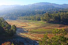
Alma in present times at low tide
-
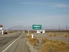
A sign for Amboy on the west side of town
-
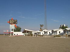
Roy's Motel and Café in Amboy on U.S. Route 66 in California in the Mojave Desert


All content from Kiddle encyclopedia articles (including the article images and facts) can be freely used under Attribution-ShareAlike license, unless stated otherwise. Cite this article:
List of ghost towns in California Facts for Kids. Kiddle Encyclopedia.