Bagdad, California facts for kids
Quick facts for kids
Bagdad, California
|
|
|---|---|
| Country | United States |
| State | California |
| County | San Bernardino |
| Founded | 1883 |
| Abandoned | 1970-72 |
| Elevation | 755 ft (230 m) |
| Time zone | UTC-8 (PST) |
| • Summer (DST) | UTC-7 (PDT) |
| ZIP code |
92304
|
| Area codes | 442/760 |
| FIPS code | 06-03456 |
| GNIS feature ID | 1660291 |
Imagine a town that used to be busy but is now empty. That's a ghost town, and Bagdad is one of them! It's located in the huge, dry Mojave Desert in San Bernardino County, California.
Contents
Where is Bagdad Located?
Bagdad sits right on the famous Route 66, a historic road that many travelers used to take across America. It's found between other desert towns like Barstow and Amboy.
How Bagdad Started and Ended
The town of Bagdad began in 1883. This was when the Atchison, Topeka and Santa Fe Railway built its train line through the area. Bagdad helped support nearby mines, like the Orange Blossom Mine and the War Eagle Mine. It also served as a stop for people traveling to the Dale Mining District.
For a long time, Bagdad was a busy place along the National Old Trails Road and later, the famous Route 66. People would stop there for services and supplies.
However, things changed in 1973. A new, bigger highway called Interstate 40 opened. This new road bypassed Bagdad, meaning travelers no longer drove through the town. Without visitors and business, people started to leave.
By 1991, the remaining buildings in Bagdad were torn down. Today, there's very little left to show that a town once stood there.
Bagdad's Amazing Weather Record
Bagdad holds a special record in United States history! It had the longest period without any rain. From October 3, 1912, to November 8, 1914, it didn't rain for 767 days straight. That's over two years without a single drop!
The town is located south of the Granite Mountains and the Mojave National Preserve. It's also north of the Bullion Mountains.
The Old Airfield
South of Bagdad, there was once a small airfield called the Bagdad Intermediate Field. It was built for planes and was used around 1932. However, it stopped being used sometime between 1954 and 1958. Today, all that remains is a small, red concrete pad. This pad was once the base for an airway beacon tower, which helped guide planes.
Bagdad Café - The Movie Connection

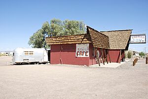
Bagdad is famous for being the made-up setting of a novel and a movie called Bagdad Café. Even though the story is set in Bagdad, the movie was actually filmed at a different cafe. It was shot at the Sidewinder Cafe in a nearby town called Newberry Springs.
After the movie became popular, the Sidewinder Cafe was renamed the "Bagdad Café." In 1990, a TV show based on the movie, also called Bagdad Cafe, was shown for one season.
 | John T. Biggers |
 | Thomas Blackshear |
 | Mark Bradford |
 | Beverly Buchanan |

