
Blythe, California facts for kids
Quick facts for kids
Blythe, California
|
|||
|---|---|---|---|

Blythe street scene, c. 1900
|
|||
|
|||

Location of Blythe in Riverside County, California.
|
|||

Blythe, California
Location in the United States
|
|||
| Country | |||
| State | |||
| County | |||
| Incorporated | July 21, 1916 | ||
| Named for | Thomas Henry Blythe | ||
| Government | |||
| • Type | Council-Manager | ||
| Area | |||
| • Total | 27.37 sq mi (70.88 km2) | ||
| • Land | 26.58 sq mi (68.85 km2) | ||
| • Water | 0.78 sq mi (2.03 km2) 2.90% | ||
| Elevation | 272 ft (83 m) | ||
| Population
(2020)
|
|||
| • Total | 18,317 | ||
| • Density | 689.05/sq mi (266.04/km2) | ||
| Time zone | UTC-8 (PST) | ||
| • Summer (DST) | UTC-7 (PDT) | ||
| ZIP codes |
92225, 92226
|
||
| Area code | 442/760 | ||
| FIPS code | 06-07218 | ||
| GNIS feature IDs | 1660349, 2409872 | ||


.jpg)
Blythe is a city in eastern Riverside County, California, in the United States. It is located in the Palo Verde Valley, which is a farming area near the Colorado River. This region is part of the Colorado Desert.
Blythe is about 224 miles (360 km) east of Los Angeles and 150 miles (241 km) west of Phoenix. The city was named after Thomas Henry Blythe, a businessman from San Francisco. He secured important water rights from the Colorado River in 1877. Blythe officially became a city on July 21, 1916. In 2020, the population was 18,317 people.
Contents
History of Blythe
How Blythe Started
In the 1870s, an engineer named William Calloway explored the area near the Colorado River. He saw that it had great potential for farming and development. Calloway then got a wealthy San Francisco businessman, Thomas Henry Blythe, interested in the land.
On July 17, 1877, Blythe claimed water rights from the Colorado River. This was a big step for developing the area. He hired George Irish and later C.C. Miller to help build an irrigation system. Thomas Blythe passed away in 1883. After his death, work in the valley stopped for a while.
Growth and Transportation
Later, in 1904, Frank Murphy and Ed Williams realized the area was perfect for cattle and farming. They bought Blythe's land and started the Palo Verde Land and Water Company.
A major change happened on August 8, 1916, when the California Southern Railroad reached Blythe. This train connection helped the valley grow quickly. Farmers could now easily ship their crops, especially cotton, to other places. This led to a very prosperous time for Blythe.
In 1928, the first car bridge was built over the Colorado River, connecting Blythe to Ehrenberg, Arizona. This made travel much easier. Later, in 1972, Interstate 10 was built through the city. This highway became the main road, making Blythe an important stop for travelers.
Geography and Weather
Where is Blythe Located?
Blythe is located near the border between California and Arizona. It is in the Colorado Desert, which is part of the larger Sonoran Desert. The city sits where Interstate 10 and US 95 meet.
The city covers about 27 square miles (70 km2). Most of this area is land, with a small part being water.
Nearby Places
Blythe is surrounded by other communities. To the north are Lost Lake and Vidal. To the south is Ripley, and to the west is Desert Center. Across the river to the east is Ehrenberg, Arizona.
Larger cities nearby include Yuma (85 miles or 137 km away) and Indio (95 miles or 153 km away). Blythe is also about 150 miles (241 km) from Phoenix and 170 miles (274 km) from San Bernardino.
Blythe's Climate
Blythe has a desert climate, which means it has very hot summers and mild winters. On average, there are about 178 days each year where the temperature reaches 90°F (32°C) or higher. The record high temperature was 124°F (51°C) on June 20, 2016.
Winters are much cooler, with about 19 days where the temperature drops to 32°F (0°C) or lower. The record low temperature was 5°F (-15°C) on January 6, 1913.
Blythe does not get much rain. On average, there are only about 16 days with measurable rain each year. The wettest year on record was 1951, and the driest was 1956.
| Climate data for Blythe, California | |||||||||||||
|---|---|---|---|---|---|---|---|---|---|---|---|---|---|
| Month | Jan | Feb | Mar | Apr | May | Jun | Jul | Aug | Sep | Oct | Nov | Dec | Year |
| Mean daily maximum °F (°C) | 67 (19) |
73 (23) |
79 (26) |
87 (31) |
95 (35) |
105 (41) |
109 (43) |
107 (42) |
101 (38) |
89 (32) |
75 (24) |
66 (19) |
88 (31) |
| Mean daily minimum °F (°C) | 40 (4) |
44 (7) |
48 (9) |
54 (12) |
62 (17) |
69 (21) |
77 (25) |
76 (24) |
69 (21) |
57 (14) |
45 (7) |
39 (4) |
57 (14) |
| Average precipitation inches (mm) | 0.51 (13) |
0.57 (14) |
0.34 (8.6) |
0.11 (2.8) |
0.07 (1.8) |
0.03 (0.76) |
0.18 (4.6) |
0.65 (17) |
0.55 (14) |
0.25 (6.4) |
0.22 (5.6) |
0.50 (13) |
3.98 (101.56) |
| Source: www.weather.com | |||||||||||||
Interestingly, even though California is known for earthquakes, geologists say that Blythe has not had an earthquake centered in the city for over 500,000 years.
Fun Things to Do in Blythe
Tourism and Activities
Tourism is a big part of Blythe's economy. Many travelers stop here because it's about halfway between Los Angeles and Phoenix. During the winter, many visitors come to Blythe to escape colder weather up north. The population in the area can grow a lot during these months.
Blythe has many things for people to enjoy. There are 24 churches, a library, and two local newspapers. You can also find two museums, two radio stations, and three banks.
For outdoor fun, Blythe is popular with campers and hikers. It has six parks, seven campgrounds, and seven R.V. parks. There are also three boat ramps for access to the Colorado River and an 18-hole public golf course.
Events and Sports
Blythe hosts the Blythe Blue Grass Festival every year in January. This festival brings together musicians and fans of bluegrass music.
Dove hunting is also a popular activity in Blythe, with the hunting season starting on September 1st.
For sports fans, the Blythe Heat was a professional minor league baseball team. They played at Alexander Field in Todd Park.
Population and People
| Historical population | |||
|---|---|---|---|
| Census | Pop. | %± | |
| 1920 | 1,622 | — | |
| 1930 | 1,020 | −37.1% | |
| 1940 | 2,355 | 130.9% | |
| 1950 | 4,089 | 73.6% | |
| 1960 | 6,023 | 47.3% | |
| 1970 | 7,047 | 17.0% | |
| 1980 | 6,805 | −3.4% | |
| 1990 | 8,428 | 23.9% | |
| 2000 | 12,155 | 44.2% | |
| 2010 | 20,817 | 71.3% | |
| 2020 | 18,317 | −12.0% | |
| U.S. Decennial Census | |||
Who Lives in Blythe?
According to the 2010 United States Census, Blythe had a population of 20,817 people. The city had about 772 people per square mile (298 per km2).
About 62% of the population lived in regular homes. A significant portion of the city's population includes people living in the Chuckawalla Valley State Prison and Ironwood State Prison. Each of these prisons can hold up to 3,000 people.
The median age in Blythe in 2010 was 38 years old. About 20% of the population was under 18 years old.
In 2010, the average household income in Blythe was $48,327. About 16% of the population lived below the federal poverty line.
Public Services in Blythe
Government and Safety
Blythe has its own police department and a volunteer fire department to keep the community safe. The Riverside County Sheriff's Department also has an office in Blythe.
Emergency medical services are provided by American Medical Response, with ambulances available 24 hours a day.
Education in Blythe
The Palo Verde Unified School District manages the public schools in the Blythe area. This includes three elementary schools and one high school. There is also a school for adult education.
For higher education, Palo Verde College is located in Blythe. It is part of the California Community College system.
Getting Around Blythe
Interstate 10 runs through Blythe from east to west. U.S. Route 95 also crosses the eastern part of the city.
The Blythe Airport (BLH) is just west of the city, near Interstate 10. It has a long runway, about 6,500 feet (1,981 meters).
For public transportation, Blythe is served by the Palo Verde Valley Transit Agency. Greyhound buses also make stops in Blythe.
Healthcare and Other Services
Blythe has a hospital called Palo Verde Hospital. It is a general hospital with 55 beds and emergency services available all day and night. There are also many doctors, dentists, and other health professionals in the city.
The Palo Verde Cemetery District takes care of the Palo Verde Cemetery.
Images for kids
-
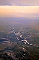
An aerial view of the Colorado River near Blythe, showing the Palo Verde Diversion Dam

See also
 In Spanish: Blythe (California) para niños
