Ripley, California facts for kids
Quick facts for kids
Ripley
|
|
|---|---|

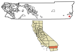
Location in Riverside County, California
|
|
| Country | United States |
| State | California |
| County | Riverside |
| Area | |
| • Total | 1.701 sq mi (4.405 km2) |
| • Land | 1.701 sq mi (4.405 km2) |
| • Water | 0 sq mi (0 km2) 0% |
| Elevation | 249 ft (76 m) |
| Population
(2020)
|
|
| • Total | 538 |
| • Density | 316.3/sq mi (122.13/km2) |
| Time zone | UTC-8 (Pacific (PST)) |
| • Summer (DST) | UTC-7 (PDT) |
| ZIP codes |
92272
|
| Area code(s) | 760 |
| GNIS feature ID | 2583122 |
Ripley is a small community in eastern Riverside County, California. It is a census-designated place, which means it's an area the government counts for population. Ripley is located along State Route 78 (SR78). It sits between the towns of Palo Verde and Blythe.
Most of the land around Ripley is used for farming. These farms get their water from the Colorado River. The community is about 249 feet (76 m) above sea level. In 2020, about 538 people lived in Ripley.
Contents
History of Ripley
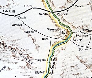
Ripley was started in 1920. This happened when the California Southern Railroad extended its tracks from Blythe. The town was named after Edward Payson Ripley. He was a former president of the Santa Fe Railway.
The town was first planned to be a resort. However, a big flood in 1922 damaged part of the valley. This flood changed the plans for Ripley. Today, an old water tower still stands as a landmark in the town.
Ripley is also near the place where a bus accident happened in 1974.
Location and Climate
Ripley covers an area of about 1.7 square miles (4.4 km2) (4.4 square kilometers). All of this area is land. Ripley is located in the Palo Verde Valley, along with Blythe and Palo Verde.
The community uses area code 760 for phones. It also has its own ZIP code, which is 92272.
Weather in Ripley
Ripley has a desert climate. This means it gets a lot of sunshine all year round. The weather is usually very stable. On climate maps, this type of weather is called "Bwh" by the Köppen Climate Classification system.
Farming and Water Use
The area around Ripley is mostly used for irrigated farming. This means farmers use water to help their crops grow. Some of the farms here include David Brown and Sons, Lawrence Chaffin Farms, and Red River Farms.
The Metropolitan Water District has an agreement with the United States Bureau of Reclamation. They sometimes pay farmers not to grow crops. This is done to save water, which can then be used for other important purposes.
The Palo Verde Irrigation District provides water to the farms in the area. The railroad tracks of the Arizona and California Railroad used to serve the area. Now, the Blythe Division track ends just west of Ripley.
People of Ripley
In 2010, the population of Ripley was 692 people. The community had about 407 people per square mile.
Most of the people in Ripley lived in homes. There were 218 households in total. Many households, about 56%, had children under 18 living there. The average household had about 3 people.
The population included people of different ages. About 38% of the people were under 18 years old. About 9% were 65 years or older. The average age in Ripley was 24.8 years.
Most homes in Ripley were rented. About 64% of the people lived in rental homes. The rest, about 36%, lived in homes they owned.
See also
 In Spanish: Ripley (California) para niños
 | Valerie Thomas |
 | Frederick McKinley Jones |
 | George Edward Alcorn Jr. |
 | Thomas Mensah |


