Palo Verde Valley facts for kids

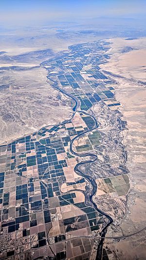
The Palo Verde Valley is a special place in Southern California. It sits right next to the border with Arizona, in the Lower Colorado River Valley. This valley is part of the Colorado Desert, which is inside the bigger Sonoran Desert. Most of it is in Riverside County. A smaller part is in Imperial County. The Colorado River forms its eastern border with Arizona. Long ago, this area was home to Native American tribes. These included the Quechan, Chemehuevi, and Halchidhoma people. Some of their descendants still live on Indian reservations nearby today.
Contents
Valley Geography and Surroundings
The Palo Verde Valley is a part of the Colorado Desert. This desert is itself a part of the larger Sonoran Desert. To the north of the valley are the Big Maria Mountains. The Colorado River creates the valley's eastern and southern borders. Other mountains nearby include the McCoy Mountains to the west. The Chocolate Mountains are to the south. You can find the Little Maria Mountains to the northwest. The Dome Rock Mountains are located to the east.
Life and Work in the Valley
Farming is the most important industry in the Palo Verde Valley. People have been farming here since ancient times. Important crops grown include melons, alfalfa, cotton, and different vegetables. The Palo Verde Irrigation District (PVID) helps farmers. It gets water from the Palo Verde Diversion Dam. This water then flows through a system of canals to the fields. The PVID has the oldest rights to water from the Colorado River in California. These rights date back to 1877.
The city of Blythe is in the middle of the Palo Verde Valley. It is the only incorporated city here. Other smaller communities include Mesa Verde, Ripley, and Palo Verde. Across the Colorado River, to the south, is the Cibola Valley.
In 2005, a deal was made about water. The Metropolitan Water District of Southern California (MWD) made an agreement with PVID. This deal meant that some farmland would be left unplanted for 35 years. This is called "fallowing" land. The water that would have been used for farming then goes to the MWD. This helps provide water to cities.
A study from 1990 showed that this change affected farming jobs. To help the community, the MWD provided $6 million. This money was to help make up for jobs lost when water moved to cities. California uses more water from the Colorado River than it is allowed. This water transfer agreement also helps to reduce how much water California takes from the river overall.
By 2015, the MWD bought more land in the valley. They purchased over 12,000 acres (4,900 hectares) of land. They already owned 9,000 acres (3,600 hectares) by 2004. This made the MWD the biggest landowner in the PVID area. The Irvine Ranch Water District also bought 3,100 acres (1,300 hectares) of land.
Getting Around the Valley
Interstate 10 runs through the Palo Verde Valley. It goes east and west, passing through Blythe. US Route 95 also goes through the northeastern part of the valley. California State Route 78 ends near the western edge of the valley, close to Interstate 10.
The Blythe Airport is located west of the valley. For many years, the Arizona and California Railroad provided train service to the valley. This service stopped in 2007.
 | May Edward Chinn |
 | Rebecca Cole |
 | Alexa Canady |
 | Dorothy Lavinia Brown |

