
Yuma, Arizona facts for kids
Quick facts for kids
Yuma, Arizona
|
|||
|---|---|---|---|
      Clockwise from top: Old Yuma City Hall, Yuma Theatre, Old Yuma Post Office, Ocean to Ocean Bridge, Yuma water tower, Yuma County Courthouse
|
|||
|
|||

Location of Yuma in Yuma County, Arizona
|
|||

Yuma, Arizona
Location in Arizona

Yuma, Arizona
Location in the United States
|
|||
| Country | United States | ||
| State | Arizona | ||
| County | Yuma | ||
| Incorporated | 1914 | ||
| Government | |||
| • Type | Council-Manager | ||
| • Body | Yuma City Council | ||
| Area | |||
| • City | 120.84 sq mi (312.97 km2) | ||
| • Land | 120.77 sq mi (312.79 km2) | ||
| • Water | 0.07 sq mi (0.18 km2) 0.07% | ||
| Elevation | 256 ft (78 m) | ||
| Population
(2020)
|
|||
| • City | 95,548 | ||
| • Density | 791.18/sq mi (305.47/km2) | ||
| • Urban | 135,717 (US: 253rd) | ||
| • Metro | 203,247 (US: 214th) | ||
| Demonym(s) | Yuman | ||
| Time zone | UTC−7 (MST) | ||
| ZIP codes |
85364–85367, 85369, 85350
|
||
| Area code(s) | 928 | ||
| FIPS code | 04-85540 | ||
| GNIS ID | 2412328 | ||
| Major airport | Yuma International Airport | ||
| Website | www.yumaaz.gov | ||

Yuma is a city in Arizona, United States. It is the main city of Yuma County. In 2020, about 95,548 people lived there.
Yuma is the biggest city in the Yuma Metropolitan Area. This area includes all of Yuma County. In 2020, about 203,247 people lived in the Yuma area.
Guinness World Records calls Yuma the "Sunniest City on Earth." It gets sunshine and warm weather for at least 91% of the year. Because of this great weather, many visitors, from 70,000 to over 85,000, come to Yuma to spend the winter.
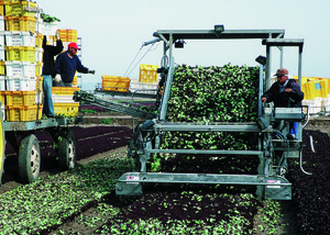
Yuma's weather also helps it grow a lot of crops. Farmers here grow over 175 types of crops. The biggest crop is lettuce. From November to March, Yuma County provides 90% of all the leafy vegetables grown in the United States. Yuma is also home to many military members. This is because of bases like the Marine Corps Air Station Yuma.
Yuma is located in the southwest part of Arizona. It is in the Sonoran Desert, specifically the Yuma Desert area.
Contents
History of Yuma


For thousands of years, Native American groups lived in the Yuma area. Their descendants still live on the Cocopah and Quechan reservations today.
In 1540, Spanish explorers like Hernando de Alarcón and Melchior Díaz visited the area. They quickly saw that the Colorado River here was a perfect place to cross. The river narrows to less than 1,000 feet (300 m) wide in one spot. Many military groups crossed the Colorado River at the Yuma Crossing. These included Juan Bautista de Anza in 1774, the Mormon Battalion in 1848, and the California Column in 1862.
During and after the California Gold Rush, until the late 1870s, the Yuma Crossing was famous for its ferry crossings. These ferries helped people travel on the Southern Emigrant Trail. This spot was known as the "gateway to California." It was one of the few natural places where travelers could cross the very wide Colorado River.
First Settlements in Yuma
After the United States built Fort Yuma, two towns grew about a mile downriver. One town was on the California side. It was called Jaeger City. It was named after the owner of Jaeger's Ferry. For a while, this town was bigger. It had the Butterfield Overland Mail office, two blacksmiths, a hotel, and two stores.
The other town was called Colorado City. It was built on the south side of the river in what is now Arizona. Charles Poston started this town. It was where the custom house was located. When it began, it was just north of the border between Mexico and California. After the Gadsden Purchase, the town was on the border of the Territory of New Mexico. This area became the Territory of Arizona in 1863.
In 1853, a smaller settlement called Arizona City started to grow. It was on higher ground across from the fort. It had adobe homes, two stores, and two saloons. In 1862, a huge flood almost destroyed Colorado City and Jaeger City. They had to be rebuilt on higher ground. After this, Colorado City became part of Arizona City. Later, in 1873, Arizona City changed its name to Yuma.
Early Growth of Yuma
From 1854, Colorado City was a major stop for steamboats on the Colorado River. After the 1862 flood, it became part of Arizona City. Steamboats carried people and supplies for mines and military posts along the Colorado River. Colorado City was also where wagons loaded goods to travel up the Gila River into New Mexico Territory.
Goods were unloaded from ships at the mouth of the Colorado River. This happened at Robinson's Landing and later at Port Isabel starting in 1864. From 1864, the Yuma Quartermaster Depot supplied all forts in what is now Arizona. It also supplied large parts of Colorado and New Mexico. In 1871, Yuma became the county seat for Yuma County. It replaced La Paz, which was the first county seat.
The Southern Pacific Railroad built a bridge over the river in 1877. The railroad also bought the only steamboat company on the river. Yuma then became the main place for river travel. This meant Port Isabel was no longer needed and was abandoned in 1879. Its warehouses and shipyard were moved to Yuma.
Geography of Yuma
Yuma is located near the borders of California to the west and Mexico to the south. It is just west of where the Gila River meets the Colorado River. The city is about 60 miles (100 km) from the Gulf of California (also called the Sea of Cortez). This gulf is part of the Pacific.
The city covers a total area of about 106.7 square miles (276 km2). Most of this, about 106.6 square miles (276 km2), is land. Only a small part, about 0.1 square miles (0.26 km2), is water.
Yuma's Climate
Yuma is famous for its extreme weather. It is the driest, sunniest, and least humid place in the United States. It also has the fewest rainy days. Yuma has 175 days per year where the temperature reaches 90 °F (32 °C) or higher.
Yuma has a hot desert climate. This means it has very hot summers and warm winters. The air is usually very dry. Sometimes, moist air from the Gulf of California comes north. This usually happens during the summer monsoon or when a tropical storm passes by.
The sun shines for about 90% of the daylight hours in Yuma. This makes it one of the sunniest places in the world. Yuma gets the most recorded sunshine on Earth.
On average, Yuma gets about 3.36 inches (85 mm) of rain each year. Even in the wettest year of 2005, only 7.39 in (188 mm) of rain fell. The driest year was 2007, with only 0.15 in (3.8 mm) recorded. The wettest months are usually August and September, during the monsoon season. December also gets rain from winter storms coming from the Pacific Ocean. June is the driest month, with almost no rain.
In 1995, Yuma had its hottest temperature ever recorded: 124 °F (51 °C). The lowest temperature was in January 2007. It dropped to 21 °F (−6 °C) for about two hours. This cold weather hurt many crops grown in Yuma. Lemon crops were especially damaged. A report in February 2007 said that 75% to 95% of citrus crops and trees were lost. On average, the temperature reaches freezing point only once every fifteen years. There are 117 days per year when the temperature reaches or goes above 100 °F (38 °C). This usually happens from April through October. In July and August, the temperature almost always reaches 100 °F (38 °C).
In 1997, a full tropical storm hit Yuma. Hurricane Nora made landfall at the mouth of the Colorado River. It then quickly moved north along the river. This rare event caused power outages for 12,000 homes in Yuma. It also dropped 3.59 inches (91 mm) of rain at Marine Corps Air Station Yuma. The last time a hurricane hit near Yuma was in 1977.
| Climate data for Yuma, Arizona (Yuma Int'l), 1981–2010 normals, extremes 1878–present | |||||||||||||
|---|---|---|---|---|---|---|---|---|---|---|---|---|---|
| Month | Jan | Feb | Mar | Apr | May | Jun | Jul | Aug | Sep | Oct | Nov | Dec | Year |
| Record high °F (°C) | 88 (31) |
97 (36) |
102 (39) |
107 (42) |
120 (49) |
122 (50) |
124 (51) |
120 (49) |
123 (51) |
112 (44) |
98 (37) |
91 (33) |
124 (51) |
| Mean maximum °F (°C) | 79.4 (26.3) |
85.0 (29.4) |
92.9 (33.8) |
100.0 (37.8) |
106.8 (41.6) |
112.6 (44.8) |
114.7 (45.9) |
114.3 (45.7) |
110.8 (43.8) |
102.1 (38.9) |
89.1 (31.7) |
77.8 (25.4) |
116.2 (46.8) |
| Mean daily maximum °F (°C) | 69.6 (20.9) |
73.8 (23.2) |
79.9 (26.6) |
86.4 (30.2) |
95.3 (35.2) |
103.5 (39.7) |
106.8 (41.6) |
106.2 (41.2) |
101.3 (38.5) |
89.9 (32.2) |
77.5 (25.3) |
68.3 (20.2) |
88.2 (31.2) |
| Mean daily minimum °F (°C) | 47.6 (8.7) |
50.1 (10.1) |
54.4 (12.4) |
59.6 (15.3) |
67.3 (19.6) |
74.6 (23.7) |
82.1 (27.8) |
82.3 (27.9) |
76.5 (24.7) |
65.0 (18.3) |
53.9 (12.2) |
46.6 (8.1) |
63.3 (17.4) |
| Mean minimum °F (°C) | 37.3 (2.9) |
39.7 (4.3) |
43.9 (6.6) |
49.1 (9.5) |
56.4 (13.6) |
64.3 (17.9) |
74.1 (23.4) |
73.6 (23.1) |
65.3 (18.5) |
54.2 (12.3) |
43.1 (6.2) |
36.4 (2.4) |
34.6 (1.4) |
| Record low °F (°C) | 22 (−6) |
25 (−4) |
31 (−1) |
38 (3) |
39 (4) |
50 (10) |
61 (16) |
58 (14) |
50 (10) |
35 (2) |
29 (−2) |
22 (−6) |
22 (−6) |
| Average precipitation inches (mm) | 0.36 (9.1) |
0.33 (8.4) |
0.34 (8.6) |
0.12 (3.0) |
0.03 (0.76) |
0.01 (0.25) |
0.26 (6.6) |
0.52 (13) |
0.53 (13) |
0.21 (5.3) |
0.20 (5.1) |
0.45 (11) |
3.36 (85) |
| Average precipitation days (≥ 0.01 in) | 2.3 | 2.0 | 1.8 | .8 | .4 | .2 | .9 | 2.3 | 1.2 | 1.1 | 1.0 | 2.1 | 16.2 |
| Mean monthly sunshine hours | 268.4 | 270.8 | 335.5 | 365.5 | 407.4 | 415.4 | 392.6 | 375.6 | 341.7 | 319.6 | 270.1 | 252.7 | 4,015.3 |
| Percent possible sunshine | 84 | 88 | 90 | 94 | 95 | 97 | 90 | 91 | 92 | 91 | 86 | 81 | 90 |
| Source: NOAA | |||||||||||||
Snow has only been recorded in Yuma once. On December 12, 1932, a light layer of snow covered the city. A few snowflakes mixed with rain also fell in January 1937 and December 1967.
Yuma's Population
| Historical population | |||
|---|---|---|---|
| Census | Pop. | %± | |
| 1860 | 130 | — | |
| 1870 | 1,144 | 780.0% | |
| 1880 | 1,200 | 4.9% | |
| 1890 | 1,773 | 47.8% | |
| 1900 | 1,519 | −14.3% | |
| 1910 | 2,914 | 91.8% | |
| 1920 | 4,237 | 45.4% | |
| 1930 | 4,892 | 15.5% | |
| 1940 | 5,325 | 8.9% | |
| 1950 | 9,145 | 71.7% | |
| 1960 | 23,974 | 162.2% | |
| 1970 | 29,007 | 21.0% | |
| 1980 | 42,481 | 46.5% | |
| 1990 | 54,923 | 29.3% | |
| 2000 | 77,515 | 41.1% | |
| 2010 | 93,064 | 20.1% | |
| 2020 | 95,548 | 2.7% | |
| U.S. Decennial Census | |||
Yuma first appeared on the U.S. Census in 1860. It was called "Arizonia" (Arizona City) back then. It was part of Arizona County, New Mexico Territory. It was listed as Arizona City again in 1870. Then, in 1873, it became Yuma. On April 12, 1902, Yuma officially became a town. It became a city on April 7, 1914.
Population Today
As of 2022[update] American Community Survey, Yuma had about 98,517 people and 39,210 households. The city had about 813.9 inhabitants per square mile (314.2/km2) people per square mile. There were 45,408 housing units.
About 39.7% of the people were White. About 27.9% were of another race. About 2.4% were Black or African American. About 1.5% were Asian, and 0.8% were Native American. About 27.7% were from two or more races. People of Hispanic or Latino background made up 66.5% of the population.
In 37.8% of households, there were children under 18. In 32.2% of households, there were seniors aged 65 or older. About 48.2% of households were married couples. The average household size was 2.45 people.
About 26.3% of the people were under 18. About 17.7% were 65 or older. The average age was 33.6 years.
The average income for a household was $58,043. For families, it was $65,926. The average income per person was $31,467. About 9.8% of people lived below the poverty line. This included 10.5% of children and 11.6% of seniors.
Yuma's Economy

The Yuma area has a high unemployment rate. This is because many people work seasonally in farming. Yuma is often called the "Winter Lettuce Capital of the World."
Top Employers in Yuma
Here are the top employers in the Yuma area in 2018:
| # | Employer | # of employees |
|---|---|---|
| 1 | Marine Corps Air Station Yuma | 5,568 |
| 2 | Yuma Union High School District | 3,100 |
| 3 | U.S. Army Yuma Proving Ground | 2,382 |
| 4 | Yuma Regional Medical Center | 2,300 |
| 5 | Yuma County | 1,437 |
| 6 | Yuma Elementary School District | 1,400 |
| 7 | City of Yuma | 1,274 |
| 8 | TRAX | 1,125 |
| 9 | United States Border Patrol | 1,000 |
| 10 | Arizona Western College | 987 |
Other big employers include Bose, Dole Fresh Vegetables, and Shaw Industries.
Arts and Culture in Yuma
.jpg)

Yuma has several historical places. These include the Yuma Territorial Prison and the Yuma Quartermaster Depot State Historic Park. It also has a historic downtown area. Yuma is known as an Arizona Main Street City. The Territorial Prison and Quartermaster Depot are now run by the Yuma Crossing National Heritage Area and the City of Yuma. The Yuma Visitors' Bureau helps visitors learn about the community.
Near Yuma, you can find the Kofa Mountain Range and a wildlife refuge. There are also Martinez and Mittry Lakes, and the Algodones Dunes.
The city is home to the Marine Corps Air Station Yuma. This base holds an annual air show and many large military exercises. There is also the Yuma Proving Ground, an Army base that tests new military equipment. The Yuma Proving Ground also has a special school. It teaches Special Forces how to do free-fall parachute jumps.
The Colorado River runs along the north and west sides of Yuma. It forms the border between Arizona and California. Yuma is an important stop for trucks moving goods between California, Arizona, and Mexico.
The Rialto movie theater used to have a very expensive pipe organ. This organ was played to go along with silent films. It has now been moved to the Yuma Theatre.
Every February, people in Yuma enjoy the annual rodeo. It's called the Yuma Jaycees Silver Spur Rodeo. A parade starts the events. Cowboys and cowgirls from all over the country come to compete.
The Yuma County Fair happens every spring at the fairgrounds in Yuma.
On New Year's Eve 2018, the town of Yuma dropped a head of iceberg lettuce from its water tower. This was to celebrate the new year, like the ball drop in New York City's Times Square. This event is called the "Iceberg Drop."
Sports in Yuma
Yuma has a stadium just for soccer, called Desert Sun Stadium. A soccer team called Frontera United played there from 2015 to 2017. Before that, it was a baseball field. It was home to the Yuma Desert Rats baseball team. The San Diego Padres baseball team used the field for spring training from 1969 to 1993. A Japanese baseball team, the Yakult Swallows, also used it for spring training from 1995 to 2015. Many local sports clubs are in the area. This includes the Yuma Sidewinders Rugby Football Club. This rugby team plays in Arizona, California, and Nevada. They also have home games in Yuma.
Education in Yuma


The city's public high schools are part of the Yuma Union High School District. Yuma has five public high schools: Yuma Union High School, Kofa High School, Cibola High School, Gila Ridge High School, and Vista Alternative High School. There are also private high schools like Yuma Catholic High School and Calvary Baptist School. Yuma also has three charter high schools: Desert View Middle & High School, Harvest Preparatory Academy, and YPIC Charter High School.
Yuma has two main elementary school districts: District One and Crane District. These include several elementary and junior high schools. Yuma also has four charter elementary schools: AmeriSchools Academy North and South, Harvest Preparatory Academy, and Desert View Academy.
In addition, Yuma has six private elementary schools. These are Yuma Lutheran School, Yuma Adventist Christian School, Immaculate Conception School, St. Francis of Assisi School, Calvary Baptist School, and Southwestern Christian School.
Arizona Western College is Yuma's community college. It is a choice for students who want to transfer to a university or get a job quickly.
All three public state universities offer programs at the AWC Yuma campus. Northern Arizona University has a branch campus there. Arizona State University has an ASU Local site. The University of Arizona has a facility next to the campus.
Yuma has the Yuma County Library District. It has a Main Library and several smaller branches. These branches are in Somerton, Wellton, Fortuna Foothills, and San Luis. A new, modern main library is now open.
Media in Yuma
- Yuma Sun newspaper
- KECY-TV FOX, ABC, CW and Telemundo Affiliate
- KYMA-DT NBC and CBS Affiliate
- KCFY 88.1 KCFY Christian Radio
- KAWC-FM 88.9 FM Public Radio (Arizona Western College)
- KYRM 91.9 FM Radio Manantial
- KLJZ 93.1 FM Adult Contemporary Radio
- KTTI 95.1 FM Country Radio
- XHMIX 98.3 FM Top 40 Radio
- KQSR 100.9 FM Adult Contemporary Radio
- KCEC 104.5 FM Regional Mexican Radio
- KBLU 560 AM Talk Radio
- KOFA 1320 AM Public Radio (Arizona Western College)
- KCYK 1400 AM Country Radio
Transportation in Yuma
- Yuma County Area Transit (local bus service)
- Yuma International Airport (for flights)
- Yuma Station (Amtrak train service)
- Greyhound Lines (bus service)
- FlixBus (bus service)
- Camel Express (bus service to Quartzsite, Arizona)
- Interstate 8 (major highway)
- Business Loop 8
- U.S. Route 95
- Arizona State Route 195
Famous People from Yuma
- Alex Barrett (born 1994), American football player
- Ryan Bedford, Olympic speed skater
- Darrell Bevell, football coach for the Miami Dolphins
- Cesar Chavez, Mexican American civil rights leader
- Curley Culp, NFL player for Kansas City Chiefs, in the Pro Football Hall of Fame
- Eduardo Franco (born 1994), actor
- Kelvin Gastelum, a champion in the Ultimate Fighting Championship
- Ron Jessie, NFL wide receiver for Los Angeles Rams
- Mike Marshall, baseball manager, won two World Series rings
- Bengie Molina, Major League Baseball catcher
- Cain Velasquez, UFC heavyweight champion
See also
 In Spanish: Yuma para niños
