
Quartzsite, Arizona facts for kids
Quick facts for kids
Quartzsite
|
|
|---|---|
| Quartzsite, Arizona | |

Abandoned mine near Quartzsite
|
|
| Motto(s):
"The Rock Capital of the World"
|
|

Location of Quartzsite in La Paz County, Arizona
|
|

Quartzsite
Location in Arizona

Quartzsite
Location in the United States
|
|
| Country | United States |
| State | Arizona |
| County | La Paz |
| Incorporated | 1989 |
| Area | |
| • Total | 36.30 sq mi (94.01 km2) |
| • Land | 36.30 sq mi (94.01 km2) |
| • Water | 0.00 sq mi (0.00 km2) |
| Elevation | 879 ft (268 m) |
| Population
(2020)
|
|
| • Total | 2,413 |
| • Density | 66.48/sq mi (25.67/km2) |
| Time zone | UTC-7 (MST (no DST)) |
| ZIP codes |
85346, 85359
|
| Area code(s) | 928 |
| FIPS code | 04-58010 |
| GNIS feature ID | 0009866 |
| Website | Town of Quartzsite |
Quartzsite is a small town in La Paz County, Arizona, United States. In 2020, about 2,413 people lived there. It's known as "The Rock Capital of the World" because of its many gem and mineral shows.
The town is located right on Interstate 10. This major highway connects Quartzsite with U.S. Route 95 and Arizona State Route 95.
Contents
History of Quartzsite
Quartzsite started as a water stop and stagecoach station. This was back in the 1860s to 1880s. It was first called Tyson's Wells. This name came from a waterhole on Tyson Wash. The area was part of Yuma County at that time.
Tyson's Wells was about 20 miles from the Colorado River steamboat landing of La Paz. It was also 25 miles from Ehrenberg. Travelers on the La Paz - Wikenburg Road would stop here.
In 1875, a traveler named Martha Summerhayes wrote about Tyson's Wells. She said it was not a very inviting place. She preferred to sleep in her tent there.
People have found gold in the valley around Tyson's Wells for many years. Individual gold seekers worked here from the 1860s to the 1950s. Some bigger mining projects in the early 1900s were not successful.
Geography and Climate
Quartzsite is located in the western part of the La Posa Plain. It covers about 94 square kilometers (36 square miles) of land. The town sits along Tyson Wash.
Mountains surround Quartzsite. The Dome Rock Mountains are to the west. Granite Mountain is to the southwest, and Oldman Mountain is to the northwest. The Plomosa Mountains are across the plain to the east.
Weather in Quartzsite
Quartzsite has a hot desert climate. This means it has mild to warm winters. These last from November to March. Summers are very hot, from April to October.
In the middle of summer, Quartzsite is one of the hottest places in the United States. The temperature has reached as high as 122°F (50°C). This happened on July 28, 1995.
The town gets very little rain. On average, only about 4.58 inches (116 mm) of rain falls each year. May and June often have no rain at all. The wettest month on record was September 1939. It received 6.16 inches (156 mm) of rain. This was from a rare hurricane that came from the Gulf of California.
People of Quartzsite
In 2020, the population of Quartzsite was 2,413 people. The town has seen its population change over the years. In 1980, there were 1,193 people. By 2010, it had grown to 3,677.
Many people who live in Quartzsite are older adults. In 2000, more than half of the population was 65 years or older. The average age was 66 years. Most households were made up of married couples. Many people also lived alone.
Things to Do and See

Quartzsite is a very popular place for people who travel in RVs. Many visitors come during the winter months. Tourism is a big part of Quartzsite's economy.
Each January, a large event called the Rubber Tramp Rendezvous takes place. It's a gathering for people who live and travel in vans.
The town is famous for its shows. There are nine major gem and mineral shows. There are also 15 general swap meet shows. These events attract about 1.5 million visitors every year. Most of them come in January and February.
Hi Jolly Monument
Quartzsite is the burial place of Hi Jolly (Hadji Ali). He was an Ottoman citizen of Greek-Syrian background. He was a camel driver in the experimental US Camel Corps. This was a group that used camels for transportation in the desert.
The Hi Jolly Monument is a special memorial for him. It was added to the National Register of Historic Places in 2011.
Other Attractions
You can also visit Joanne's Gum Museum in Quartzsite. It's open to the public. It has a huge collection of gum wrappers from all over the world.
The Arizona Peace Trail also passes through Quartzsite. This trail is popular for off-road adventures.
Getting Around Quartzsite
Quartzsite has its own bus service called Camel Express. These buses help people get around town on weekdays. They also offer weekly trips to nearby towns like Parker. There are also less frequent trips to Yuma, Blythe, and Lake Havasu City.
Greyhound Lines also has a bus stop in Quartzsite. This bus route goes from Los Angeles to Dallas.
Major roads in Quartzsite include:
 Interstate 10
 State Route 95
Historic Places Gallery
This gallery shows some important historic places in Quartzsite:
| Name | Image | Year | Name | Image | Year | ||
|---|---|---|---|---|---|---|---|
| 1 | Hagely Store Ruins (Camelot) |  |
1890 | 2 | Tyson’s Well Site |  |
1864 |
| 3 | Tyson's Well Stage Station |  |
1866 | 4 | Oasis Hotel Replica |  |
1900 |
| 5 | Hi Jolly Monument |  |
1903 |
Images for kids
-
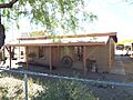
The Tyson's Well Stage Station, built in 1866, now houses the Quartzsite Museum.
-
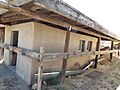
The restored Oasis Hotel, built in 1900, is next to the museum.
-
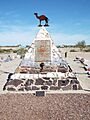
The grave of Hi Jolly (1828–1902) in the Hi Jolly Cemetery.
See also
 In Spanish: Quartzsite para niños
