
La Posa Plain facts for kids
The La Posa Plain is a large, mostly flat area of land in western Arizona. It's located close to the Colorado River. This plain forms the western and northwestern edge of the Kofa National Wildlife Refuge.
The La Posa Plain is east of the Colorado River Indian Reservation. It is also east of the Dome Rock Mountains and the Trigo Mountains. The town of Quartzsite, Arizona, sits on the western part of this plain. Major roads like Interstate 10 and U.S. Route 95 cross the plain.

Contents
What is the La Posa Plain?
A plain is a wide, flat area of land. The La Posa Plain is a great example of this. It stretches out for many miles. This flat land is important for local wildlife and people.
Where is the La Posa Plain Located?
The plain is in the western part of Arizona. It's quite close to the border with California. The mighty Colorado River flows nearby. This river helps shape the landscape of the region.
Mountains Around the Plain
Several mountain ranges surround the La Posa Plain. To the east, you'll find the Plomosa Mountains, New Water Mountains, and Kofa Mountains. To the south, the plain ends near the Castle Dome Mountains and the Chocolate Mountains.
The northern part of the plain is crossed by the Bouse Wash. This is a dry riverbed that sometimes fills with water. It runs west of the town of Bouse. The plain continues east of Parker. It ends near the Cactus Plain and the Buckskin Mountains. Arizona State Route 72 is another road that crosses the plain. It connects Bouse and Parker.
Images for kids
-
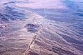
This is an aerial view of Quartzsite, Arizona. You can also see the southern La Posa Plain. The picture looks north, down the plain. The mountains on the left are the Dome Rock Mountains.

