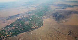
Bouse Wash facts for kids

The Bouse Wash is a large dry riverbed, also called a wash, located in western Arizona. It flows into the Colorado River in an area known as the Lower Colorado River Valley. Washes like Bouse Wash usually only have water after heavy rains.
Where is Bouse Wash?
Bouse Wash is found in La Paz County, which is in the far western part of Arizona. It sits between two flat areas: the La Posa Plain to its south and the Cactus Plain to its north.
The small Arizona town of Bouse is located right on Bouse Wash. This town is northeast of the La Posa Plain, nestled between the Bouse Hills and the Plomosa Mountains.
How Water Flows Here (Watersheds)
A watershed is an area of land where all the water that falls in it drains into the same river, lake, or ocean. The Bouse Wash watershed collects water that eventually flows into the Imperial Reservoir. This reservoir is part of the Colorado River, just south of the town of Parker.
The Imperial Reservoir is also next to the Colorado River Indian Reservation. Another wash called the Tyson Wash also flows into the Colorado River nearby. The areas where Bouse Wash and Tyson Wash collect water are right next to each other. Both of these washes empty into the Colorado River on its eastern side.
The Bouse Wash watershed is separated from another watershed by a "water divide." This is like a high ridge of land that makes water flow in different directions. East of this divide, the Centennial Wash collects water that flows east. Centennial Wash is a branch of the Gila River. The Gila River eventually joins the Colorado River.
Images for kids
-
The Bouse Wash entering the Parker Valley from the east. It flows near the Mesquite Mountains (Arizona).
 | Anna J. Cooper |
 | Mary McLeod Bethune |
 | Lillie Mae Bradford |


