Tyson Wash facts for kids
Quick facts for kids Tyson Wash |
|
|---|---|

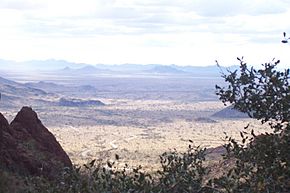
View due west from Palm Canyon
(dirt road climbs beige alluvial fan) (in foreground) Trigo Mountains, south, Dome Rock Mountains, north (farthest horizon: (in California): Chocolate, Palo Verde & Little Chuckwalla mountain ranges) |
|
| Lua error in Module:Location_map at line 420: attempt to index field 'wikibase' (a nil value).
Location of Tyson Wash in Arizona
|
|
| Country | United States |
| State | Arizona |
| Region | Lower Colorado River Valley NW-Sonoran Desert (SE-Mojave Desert-(NW & N)) |
| Municipality | Quartzsite |
| Physical characteristics | |
| Length | 50 mi (80 km), (S-to-N, then W) |
Tyson Wash is a large dry riverbed in western Arizona. It is one of the biggest "washes" that flows into the Colorado River from the east. A wash is a riverbed that is usually dry but can fill with water after heavy rain.
Tyson Wash helps drain the La Posa Plain, a flat area that stretches from south to north. It covers the southern two-thirds of this plain. Tyson Wash is part of a pair of important dry river systems in the Lower Colorado River Valley. The other one is called Bouse Wash.
Both Tyson Wash and Bouse Wash are located south of Parker. They flow into areas on the eastern edge of the Colorado River Indian Reservation. This reservation is found along the Colorado River in the Parker Valley.
Contents
Exploring Tyson Wash
Tyson Wash and Bouse Wash both feed into the upper parts of the Imperial Reservoir Drainage. This means they contribute water to the area that eventually flows into Imperial Reservoir.
The La Posa Plain Connection
Tyson Wash drains the huge La Posa Plain, which is about 75 miles (120 km) long. Many areas flow into Tyson Wash. These include the town of Quartzsite and four mountain ranges to the south. Even parts of the Kofa National Wildlife Refuge drain into this wash.
Tyson Wash creates a water divide to the south. This means it separates water flow. For example, the Castle Dome Wash and Castle Dome Plain drain to the south and southwest.
Tyson Wash flows northward along the western edge of the La Posa Plain. The Trigo Mountains are to its southwest. As it goes north, the wash turns west around the northern end of the Dome Rock Mountains.
This area is very dry, part of the western Sonoran Desert. A major road, U.S. Route 95-State Route 95, runs straight for 75 miles (120 km) across the La Posa Plain. This shows how flat and open the land is.
The La Posa Plain eventually turns northwest to meet the Colorado River. This is near the southern part of the Parker Valley. Tyson Wash stays to the southwest of the plain's direction. It enters land next to the southeastern part of the Colorado River Indian Reservation.
Quartzsite and Granite Mountain
The town of Quartzsite is located right on the central-north part of Tyson Wash. It's also east of the central Dome Rock Mountains. Granite Mountain, which is south of Interstate 10, has its own small washes that flow into Quartzsite.
Quartzsite is a popular spot for winter visitors. Many people come in their recreational vehicles (RVs) to enjoy the mild winter weather. It's also famous for rockhounding. This is where people look for cool rocks and minerals. The area has old mines and mountains rich in minerals.
Every year, Quartzsite hosts a big market called a bazaar. A large part of this event focuses on rocks and minerals. There are many ways to get to the wash and mountain areas around Quartzsite.
Getting to Northern Tyson Wash
You can reach the northern part of Tyson Wash by taking a dirt road west of AZ Route 95. This road is about 25 miles (40 km) long. It leads to the southern area of the Colorado River Indian Reservation. This spot is about 35 miles (56 km) north of Ehrenberg, Arizona.
This dirt road is about 2.5 miles (4 km) south of an intersection. That intersection leads to a paved road that goes northeast to Bouse. This paved road, called Plomosa Road, goes through the Plomosa Mountains. It ends at Bouse, near the Bouse Wash, and the northern end of the Ranegras Plain.
Landforms Around Tyson Wash
The area around Tyson Wash and the southern La Posa Plain has many interesting landforms. Here is a table showing some of them:
| West Mtns North |
Tyson Wash | La Posa Plain | East Mtns North |
|---|---|---|---|
| Colorado River & Parker Valley La Posa Plain |
Cactus Plain La Posa Plain |
Cactus Plain La Posa Plain |
Ranegras Plain (foothills)-Plomosa Mountains) |
| Colorado River & Colorado River Indian Reservation Tyson Wash |
xxxxxxx | La Posa Plain | Plomosa Mountains |
| Dome Rock Mountains | Tyson Wash | La Posa Plain | Plomosa Mountains |
| Interstate 10 –Quartzsite | Interstate 10 –Quartzsite | Interstate 10 –Quartzsite | Interstate 10 –Quartzsite |
| Dome Rock Mountains | Tyson Wash | La Posa Plain | New Water Mountains (abuts north of Kofa Mountains) |
| Trigo Mountains | Tyson Wash | La Posa Plain | Palm Canyon (northwest)-Kofa Mountains |
| Chocolate Mountains | Tyson Wash water divide |
water divide | King Valley (northern)-Castle Dome Mountains |
Three flat areas, or plains, meet at the north end of the La Posa Plain. The Ranegras Plain comes from the southeast and includes Bouse Wash. The Cactus Plain is in the middle.
These three plains are bordered on the northeast by a group of parallel mountain ranges and valleys. This entire area is known as the Maria fold and thrust belt. This belt contains about thirty different landforms, including plains, valleys, and mountain ranges.
 | Precious Adams |
 | Lauren Anderson |
 | Janet Collins |

