
Trigo Mountains facts for kids
Quick facts for kids Trigo Mountains |
|
|---|---|

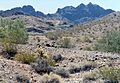
This picture shows a Buckhorn Cholla cactus, Creosote bushes, and Desert Ironwood trees. The North Trigo Peaks are in the background.
|
|
| Highest point | |
| Peak | Coyote Peak |
| Elevation | 2,808 ft (856 m) |
| Geography | |

Location in Arizona
|
|
| Country | United States |
| State | Arizona |
| Range coordinates | 33°18′17″N 114°32′50″W / 33.3047552°N 114.5471753°W |

The Trigo Mountains are a mountain range in La Paz County, Arizona. They run mostly from north to south. These mountains are right next to the Colorado River on its eastern side, in a place called the Lower Colorado River Valley. The Trigo Mountains are located north of where the Colorado River turns east. They are also north of Martinez Lake and the Imperial Reservoir. This mountain range forms the eastern edge of the Imperial National Wildlife Refuge.
What Makes the Trigo Mountains Special?
The Trigo Mountains stretch from north to south. The northern and middle parts of the range curve towards the northeast. This curving shape is similar to the Chocolate Mountains to the southeast, which are about half the size. Scientists believe both mountain ranges got their curved shape from the same powerful geological event. This event, called "thrust-faulting," happened when the Basin and Range Province was forming.
The highest point in the Trigo Mountains is Mohave Peak. It stands about 2,771 feet (845 meters) tall. This peak is a bit separate from the main line of the mountains. The tallest peak at the very northern end of the range is unnamed. It is about 2,170 feet (661 meters) high and is part of the North Trigo Peaks.
How to Visit the Trigo Mountains
You can get to the southern part of the Trigo Mountains from the Colorado River. This access point is near Martinez Lake. From there, you can take a dirt road that needs a 4-wheel drive vehicle to reach the Red Cloud Mine.
Getting to the northern areas of the mountains is usually easier. You can go through the valley that holds the Colorado River Indian Reservation. This reservation is on the east bank of the river in Arizona.
The city of Blythe, California, is about 12 miles (19 km) northwest of the northern parts of the Trigo Mountains. The cities of Yuma, Arizona, and Winterhaven, California, are about 30 miles (48 km) south of the central part of the range.
Images for kids
-
A single Buckhorn Cholla, Creosote bushes, and two green Desert Ironwood trees, North Trigo Peaks in the distance.
-

Vanadinite from the old Hamburg or Princess mine, Trigo Mountains.
