
Buckskin Mountains (Arizona) facts for kids
Quick facts for kids Buckskin Mountains (Arizona) |
|
|---|---|
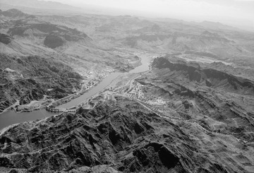
(View south)
At photo left: Buckskin Mountains (Arizona) and Castle Rock (Arizona) formation in the Buckskins, west-southwest region. Large massif at photo bottom, is the Whipple Mountains. |
|
| Highest point | |
| Peak | Battleship Peak |
| Elevation | 2,569 ft (783 m) |
| Dimensions | |
| Length | 30 mi (48 km) E-W & (SW x NE) |
| Geography | |

Location in Arizona
|
|
| Country | United States |
| Communities | Bouse, AZ and Parker Dam, CA |
| Range coordinates | 34°10′12″N 113°50′46″W / 34.17000°N 113.84611°W |
The Buckskin Mountains are a mountain range in La Paz County, Arizona, United States. These mountains are located just east of the Colorado River. They also border the Bill Williams River to the south.
Exploring the Buckskin Mountains
The Buckskin Mountains are part of a special geological area called the Maria fold and thrust belt. This area is in western Arizona and southeastern Southern California. It has many plains, valleys, and mountain ranges.
A part of the Buckskin Mountains stretches west, right up to the Colorado River. You can find Buckskin Mountain State Park here, which is south of the Bill Williams River.
Western, Central, and Southeastern Areas

(view south) The long ridgeline peak is Castle Rock.
The southeastern part of the Buckskin Mountains is connected to two other mountain ranges: the Harcuvar Mountains and the Harquahala Mountains. The tallest point in this area is Battleship Peak, which is 2,569 feet (783 meters) high. It's located northeast of Bouse.
The western end of the mountains meets the Colorado River. Here, you'll find the Gibraltar Mountain Wilderness, home to Gibraltar Mountain, which is 1,566 feet (477 meters) tall.

The entire northern edge of the range follows the Bill Williams River. Buckskin Mountain State Park is in the northwest, where the Bill Williams River meets the Colorado River. In the central part, next to the Bill Williams River, is the Swansea Wilderness. To the northeast, the Rawhide Mountains Wilderness is on both sides of the river. The northeast side of the range also borders Alamo Lake State Park. This park also borders the Rawhide Mountains.
Another peak in the central-west area is Planet Peak, standing at 3,141 feet (957 meters). It's located northeast of the Cactus Plain. The most easily recognized peak is "Black Peak," which is 1,594 feet (486 meters) tall. Locals call it "P Mountain" because the town of Parker painted a large white "P" on its west side.
Major Mountain Ranges in the Region
The main mountain ranges in the Maria fold and thrust belt region include:
- Buckskin Mountains
- Butler Valley (Arizona)
- Harcuvar Mountains
- McMullen Valley
- Harquahala Mountains
The Bill Williams River forms the northern border of these three ranges. It also acts as a natural dividing line. To the north and northwest of the river is the Mojave Desert. To the south and southeast is the Sonoran Desert.
