Rawhide Mountains facts for kids
Quick facts for kids Rawhide Mountains |
|
|---|---|
| Highest point | |
| Peak | Aubrey Peak (Rawhide Mountains) |
| Elevation | 2,953 ft (900 m) |
| Dimensions | |
| Length | 15 mi (24 km) NW-SE |
| Width | 9 mi (14 km) |
| Geography | |
| Country | United States |
| State | Arizona |
| Region | Maria fold and thrust belt ((southeast)-Mojave Desert) ((northwest)-Sonoran Desert) |
| County | Mohave County, Arizona |
| Settlement | Swansea, AZ-(ghost town) & Parker Dam, California |
| Range coordinates | 34°18′09″N 113°42′04″W / 34.3025°N 113.7010°W |
| Borders on | Bill Williams River |
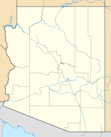
The Rawhide Mountains are a mountain range in western Arizona. They are located in the southwest part of Mohave County. These mountains are part of a larger group of ranges. This area is known as the Maria fold and thrust belt. It includes many mountains, valleys, and flat plains. The Rawhide Mountains are next to the smaller Artillery Mountains to the southeast. They also border Alamo Lake State Park and the Big Sandy River.
To the southwest, you will find the Bill Williams Mountains. To the northeast and east are the Poachie Range and the large Arrastra Mountain Wilderness.
The highest point in the Rawhide Mountains is Aubrey Peak. It stands at 2,953 feet (900 m) tall. Two other important peaks are Miller Peak, at 2,793 feet (851 m), and Fools Peak, at 2,939 feet (896 m). These peaks are located in the southeast part of the range.
The Bill Williams River forms the southern edge of the Rawhide Mountains. This river flows west. It marks the northern border of the Maria fold and thrust belt. It also helps define the edge of the southeast Mojave Desert. South of the river is the northwestern Sonoran Desert.
Exploring the Rawhide Mountains Wilderness Areas
About half of the Rawhide Mountains are protected as wilderness areas. These are special places where nature is preserved.
Aubrey Peak Wilderness
The northwest part of the Rawhide Mountains is home to the Aubrey Peak Wilderness. This wilderness covers about 15,400-acre (6,232 ha) of land. You can reach it by using dirt roads. These roads are found along the southwest and southeast edges of the area.
There are two interesting hikes for exploring the geology here. One route begins near Wikieup. Another hike, called Hike 29, is in the southern Hualapai Mountains. It leads to Centennial Wash, which is part of the wilderness's southeast border.
Rawhide Mountains Wilderness
The Rawhide Mountains Wilderness is a large protected area. It includes land on both sides of the Bill Williams River. It also covers the area where the Big Sandy River joins the Bill Williams River. This wilderness is located northeast of the Buckskin Mountains. It forms the western border of Alamo Lake, which is part of Alamo Lake State Park.
 | Jessica Watkins |
 | Robert Henry Lawrence Jr. |
 | Mae Jemison |
 | Sian Proctor |
 | Guion Bluford |


