Harquahala Mountains facts for kids
Quick facts for kids Harquahala Mountains |
|
|---|---|

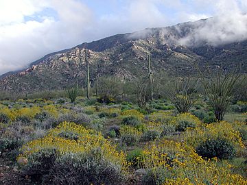
Harquahala Mountains viewed from north side following an unusually wet spring. Bright yellow shrubs are Brittle Bush, (Encelia farinosa).
|
|
| Highest point | |
| Peak | Harquahala Peak |
| Elevation | 5,681 ft (1,732 m) |
| Prominence | 3,461 ft (1,055 m) |
| Dimensions | |
| Length | 32 km (20 mi) NE-SW |
| Width | 20 km (12 mi) |
| Geography | |
| Range coordinates | 33°49′N 113°19′W / 33.817°N 113.317°W |
The Harquahala Mountains are the tallest mountain range in southwestern Arizona, United States. They are located near the towns of Aguila and Wenden. The name comes from the Yavapai word ʼHakhe:la, which means "running water."
Contents
Harquahala Mountains: Arizona's Tallest Range
What's in a Name?
The name Harquahala comes from the Yavapai people. Their word ʼHakhe:la means "running water." This is interesting because the mountains are in a very dry part of Arizona.
High Peaks and Views
This mountain range stretches about 32 kilometers (20 miles) from northeast to southwest. It is about 20 kilometers (12 miles) wide at its widest point.
At the northeast end, you'll find two special peaks. They are called Eagle Eye Peak and Eagle Eye Mountain. One of these peaks has a natural opening or bridge. It looks like an eye high up in the mountain. This "eye" gave the peaks their name. It also named the nearby town of Aguila, which means "eagle" in Spanish.
The very highest point is Harquahala Peak. It rises to 5,681 feet (1,732 meters) above sea level. At the southwest end of the range is Socorro Peak, which is 3,270 feet (1,134 meters) tall.
A Look at the Past
The top of Harquahala Peak can be reached by a rough road. Only vehicles with four-wheel drive can make it to the top.
In the 1880s, the U.S. Army used this high point. They had a heliograph station there. A heliograph is a device that uses mirrors to flash sunlight. It was used to send messages over long distances.
Later, in 1920, a special building was put on the summit. It was the Smithsonian Astrophysical Observatory. This observatory studied the sun for five years. Scientists wanted to see if changes in the sun's energy affected Earth's climate. The observatory later moved to Table Mountain Observatory in California.
Protecting Nature
A large area of these mountains is protected. It is called the Harquahala Mountain Wilderness. This wilderness area was created in 1990. It covers about 22,880 acres (92.6 square kilometers). It is located north and east of the summit. The wilderness area sits on the border between Maricopa and La Paz counties.
Hidden Treasures
At the southwest end of the mountain range, there are mines. Today, people mine for gypsum there. In the past, there were many mines for gold and silver in these mountains.
 | John T. Biggers |
 | Thomas Blackshear |
 | Mark Bradford |
 | Beverly Buchanan |

