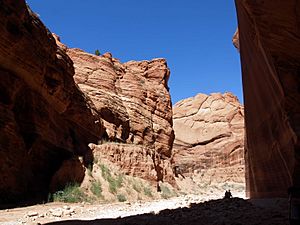
Buckskin Mountain (Arizona-Utah) facts for kids
Quick facts for kids Buckskin Mountain |
|
|---|---|
| Highest point | |
| Elevation | 6,668 ft (2,032 m) |
| Dimensions | |
| Length | 15 mi (24 km) NNE–SSW |
| Geography | |
| Country | United States |
| Topo map | USGS Buckskin Mountain |
Buckskin Mountain is a long mountain ridge in the United States. It stretches about 16 miles (26 km) across two states. You can find it in Arizona (specifically Coconino County) and Utah (in Kane County). The ridge is split almost evenly between these two counties.
What is Buckskin Mountain?

This mountain ridge is located at the northern end of the Kaibab Plateau. This area is near the North Rim of the Grand Canyon. To the southwest and southeast, you'll find the Kanab and Paria plateaus in Arizona.
Buckskin Mountain also borders the Vermilion Cliffs National Monument to its southeast. Part of the ridge in Utah used to be in the Grand Staircase–Escalante National Monument. However, it was later removed from that protected area.
The very end of the ridge to the northeast is called Buckskin Gulch. East of the ridge, across a narrow area called Coyote Valley, are the Coyote Buttes of Arizona. The ridge slopes steeply down towards Coyote Wash on its southeast side. The highest point of Buckskin Mountain is in Arizona, just south of the state border. It reaches an elevation of 6,668 feet (2,032 meters).
How Did It Get Its Name?
Before 1989, the United States Geological Survey (USGS) had identified three different mountains named Buckskin Mountain. Two were in northern Coconino County, Arizona. One was near the southern edge of central Kane County, Utah.
Even though the USGS still lists all three, a decision in 1989 changed things. This decision combined the three separate peaks into one single landform. This new, larger Buckskin Mountain now includes the areas from the Kaibab National Forest up to Buckskin Gulch.
How to Visit Buckskin Mountain
It's possible to reach the northeast, east, and south parts of Buckskin Mountain. You can get there from U.S. Route 89A (US 89A) near House Rock, Arizona. From there, you take the House Rock Road (BLM Road 1065).
This road goes almost straight north. Once it enters Utah, it becomes the House Rock Valley Road. This road then connects to U.S. Route 89 (US 89), which is about 17 miles (27 km) west of Big Water.
You can also access the west and northwest areas of Buckskin Mountain from Kanab. Another access point is Canyon Point, Utah, which is about 8 miles (13 km) east of Kanab on US 89. On the ridge's northwest side, US 89 turns northeast. From there, you can use unpaved roads to get closer.
Some unpaved roads on the west and southeast sides also connect to a paved road at the southern end of the ridge. This paved road comes from House Rock Valley Road to the east. Its western end is at US 89A, about 7 miles (11 km) east of Fredonia, Arizona.
 | Madam C. J. Walker |
 | Janet Emerson Bashen |
 | Annie Turnbo Malone |
 | Maggie L. Walker |


