Fredonia, Arizona facts for kids
Quick facts for kids
Fredonia, Arizona
|
|
|---|---|
 |
|

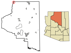
Location of Fredonia in Coconino County, Arizona.
|
|
| Country | United States |
| State | Arizona |
| County | Coconino |
| Area | |
| • Total | 8.88 sq mi (22.99 km2) |
| • Land | 8.88 sq mi (22.99 km2) |
| • Water | 0.00 sq mi (0.00 km2) |
| Elevation | 4,725 ft (1,440 m) |
| Population
(2020)
|
|
| • Total | 1,323 |
| • Density | 149.04/sq mi (57.55/km2) |
| Time zone | UTC-7 (MST) |
| ZIP codes |
86022, 86052
|
| Area code | 928 |
| FIPS code | 04-25720 |
| GNIS feature ID | 2412657 |
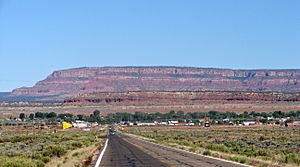
Fredonia is a small town in Coconino County, Arizona, in the United States. In 2020, about 1,323 people lived there. Fredonia is often called the 'gateway' to the North Rim of the amazing Grand Canyon. This means it's a main entry point for visitors heading to that part of the canyon.
Contents
A Look Back: Fredonia's History
Fredonia was first settled in 1886. People say its name means "land of free women." The town's cemetery has graves from the 1880s, showing how old the community is.
Economic Changes Over Time
In 1960, the town faced a big challenge. The main highway, U.S. 89, was changed. It used to go right through Fredonia. But it was rerouted north of the Glen Canyon Dam. This meant fewer cars and visitors came through town. Many local businesses suffered because of this change.
A famous politician, Senator Barry Goldwater, gave a speech at Fredonia High School in 1964. This was a special event for the town's graduates.
For many years, the biggest employer in Fredonia was Kaibab Forest Products. This company provided jobs for hundreds of people. In 1988, it employed up to 400 workers. However, in 1995, the company closed down. This meant 200 people lost their jobs, which was a tough time for the town. There is also a mine nearby called the Arizona One mine.
Who Lives in Fredonia?
| Historical population | |||
|---|---|---|---|
| Census | Pop. | %± | |
| 1960 | 643 | — | |
| 1970 | 798 | 24.1% | |
| 1980 | 1,040 | 30.3% | |
| 1990 | 1,207 | 16.1% | |
| 2000 | 1,036 | −14.2% | |
| 2010 | 1,314 | 26.8% | |
| 2020 | 1,323 | 0.7% | |
| U.S. Decennial Census | |||
In 2000, there were 1,036 people living in Fredonia. These people lived in 359 homes, and 287 of those were families. The town had about 140 people per square mile.
Most people in Fredonia in 2000 were White (85.7%). About 11.4% were Native American. A small number were Black or African American (1.1%), or from other backgrounds. About 1.5% of the people were Hispanic or Latino.
Age and Income in Fredonia
In 2000, about 32.3% of the people in Fredonia were under 18 years old. About 11.1% were 65 years or older. The average age in town was 35 years old. For every 100 females, there were about 104 males.
The average income for a household in Fredonia was $30,288 per year. For families, the average income was $30,913. About 15% of the population lived below the poverty line. This included 25.4% of children under 18.
Fredonia's Location and Weather
Fredonia is located in a special part of Arizona called the Arizona Strip. This area is north of the Colorado River. The town is also very close to the border of Utah. It covers an area of about 7.4 square miles, and all of it is land.
Fredonia is a great spot for outdoor adventures. It's close to many national parks, national monuments, and state parks. This makes it a popular place for people who love nature and exploring.
Climate of Fredonia
Fredonia has a climate with warm summers and cold winters. Here's a quick look at the weather:
| Climate data for Fredonia, Arizona | |||||||||||||
|---|---|---|---|---|---|---|---|---|---|---|---|---|---|
| Month | Jan | Feb | Mar | Apr | May | Jun | Jul | Aug | Sep | Oct | Nov | Dec | Year |
| Record high °F (°C) | 78 (26) |
72 (22) |
83 (28) |
86 (30) |
96 (36) |
107 (42) |
110 (43) |
104 (40) |
99 (37) |
96 (36) |
78 (26) |
70 (21) |
110 (43) |
| Mean daily maximum °F (°C) | 46.2 (7.9) |
51.6 (10.9) |
59.7 (15.4) |
68.5 (20.3) |
77.4 (25.2) |
87.3 (30.7) |
93.7 (34.3) |
90.7 (32.6) |
84.2 (29.0) |
72.2 (22.3) |
58.5 (14.7) |
47.9 (8.8) |
69.8 (21.0) |
| Mean daily minimum °F (°C) | 19.5 (−6.9) |
22.1 (−5.5) |
26.0 (−3.3) |
31.9 (−0.1) |
38.5 (3.6) |
46.6 (8.1) |
55.4 (13.0) |
54.2 (12.3) |
45.4 (7.4) |
35.4 (1.9) |
26.1 (−3.3) |
20.1 (−6.6) |
35.1 (1.7) |
| Record low °F (°C) | −20 (−29) |
−15 (−26) |
−2 (−19) |
2 (−17) |
18 (−8) |
26 (−3) |
34 (1) |
33 (1) |
26 (−3) |
9 (−13) |
0 (−18) |
−18 (−28) |
−20 (−29) |
| Average precipitation inches (mm) | 1.13 (29) |
0.80 (20) |
0.88 (22) |
0.62 (16) |
0.48 (12) |
0.29 (7.4) |
0.73 (19) |
1.21 (31) |
0.89 (23) |
0.90 (23) |
0.77 (20) |
0.97 (25) |
9.67 (247.4) |
| Average snowfall inches (cm) | 7.0 (18) |
3.5 (8.9) |
3.5 (8.9) |
1.1 (2.8) |
0 (0) |
0 (0) |
0 (0) |
0 (0) |
0 (0) |
0.2 (0.51) |
1.3 (3.3) |
4.8 (12) |
21.4 (54.41) |
| Average precipitation days (≥ 0.01 in) | 5 | 4 | 4 | 3 | 3 | 2 | 4 | 5 | 3 | 4 | 3 | 4 | 44 |
| Source: Western Regional Climate Center | |||||||||||||
Learning in Fredonia
Fredonia is part of the Fredonia-Moccasin Unified School District. This district has two schools that serve the town's students:
- Fredonia Elementary School
- Fredonia High/Middle School
These schools help kids from Fredonia get a good education.
See also
 In Spanish: Fredonia (Arizona) para niños
 | John T. Biggers |
 | Thomas Blackshear |
 | Mark Bradford |
 | Beverly Buchanan |


