
Southern Emigrant Trail facts for kids

The Southern Emigrant Trail was a very important land route for people moving to California from the eastern United States. It was also known by other names, like the Gila Trail or the Butterfield Stage Trail. This trail was especially popular during the California Gold Rush because it led to the gold fields.
Unlike trails further north, the Southern Emigrant Trail could be used all year round. Mountain passes on this route usually didn't get blocked by heavy snow. However, it had its own challenges, like extreme summer heat and a serious lack of water in the desert areas of New Mexico Territory and the Colorado Desert in California.
Over time, this trail became a key path for travel and trade. Many herds of cattle and sheep were moved along it. It was also used by mail services, like the San Antonio-San Diego Mail Line and the famous Butterfield Overland Mail, which carried mail and passengers from 1858 to 1861.
Contents
Exploring the Trail's History
Early Journeys: 1846–1848
In October 1846, a military leader named General Stephen Watts Kearny and his soldiers, along with their scout Kit Carson, found a way through the mountains. They traveled from the Rio Grande river, past the Santa Rita mines, and then followed the Gila River all the way to the Colorado River. They crossed the Colorado River at a place called the Yuma Crossing and then went through the Colorado Desert to Southern California. This path became known as the Gila Trail.
About a month later, Colonel Philip St. George Cooke and the Mormon Battalion found another important route. They created a wagon road that went south from the Rio Grande, through Guadalupe Pass, and then west towards Tucson. From Tucson, they connected with an older Spanish road that led to California. This new path was the first wagon road from New Mexico to California and was called Cooke's Road or the Sonora Road.
In 1848, Major Lawrence P. Graham and his soldiers also traveled this route. They made a small detour that many of the Forty-niners (people who rushed to California for gold in 1849) would later use.
After crossing the Colorado River at Yuma, the Southern Emigrant Trail went through the Colorado Desert. To avoid huge sand dunes, it dipped south into Baja California, Mexico. It followed water sources like the Alamo and New Rivers, then turned northwest back into California, reaching an oasis called Vallecito.

From Vallecito, the trail continued northwest, crossing Warners Pass to reach Warner's Ranch. From there, travelers could go northwest to Los Angeles or southwest to San Diego. From either of these cities, they could continue north by land to the gold fields or take ships to San Francisco.
Shortcuts and Changes: 1849–1880s
The Tucson Cutoff
Later, the long Cooke–Graham route was made much shorter by a path called the Tucson Cutoff. This shortcut was first used by John Coffee Hays and a group of forty-niners in late 1849. It went through places like Stein's Pass and Apache Pass, directly connecting to Cooke's Wagon Road closer to Tucson.
New Roads and Challenges
In 1856, another change was made to the Tucson Cutoff, using Dragoon Pass. Then, in 1857, after the Gadsden Purchase (when the U.S. bought land from Mexico), a military road called the Pacific Wagon Road was built. This road made the journey even shorter for travelers heading west from Mesilla to Fort Yuma. It followed parts of Cooke's Wagon Road and the Tucson Cutoff, making travel faster and easier.
From 1859 to 1861, during the time of the Butterfield Overland Mail, stagecoaches used another shortcut through Doubtful Canyon. However, this route became dangerous due to conflicts with the Apache people in 1861. Stage stations were destroyed, and it was no longer safe to use unless travelers had a strong military escort. Because of these dangers, traffic returned to the safer Pacific Wagon Road. This route remained a main east-west path in the southwest until railroads were built in the 1880s.
Images for kids
-
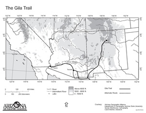
A map showing the Gila Trail, also known as the Southern Emigrant Trail
-
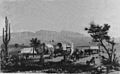
An American wagon train at Maricopa Wells in 1857, a stop on the trail
-
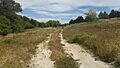
What's left of the Southern Emigrant Trail at Warner's Ranch in 2017
See also
 In Spanish: Southern Emigrant Trail para niños
