Alamo River facts for kids
Quick facts for kids Alamo River |
|
|---|---|

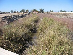
Alamo River north of Zenos Road, near Holtville, California
|
|

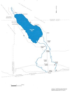
Map showing the course of the Alamo River in the United States
|
|
| Native name | Río Álamo |
| Country | Mexico, United States |
| Physical characteristics | |
| Main source | Colorado River Alamo, Baja California, Mexico 36 m (118 ft) 32°40′58″N 114°45′06″W / 32.68269°N 114.7515656°W |
| River mouth | Salton Sea −66 m (−217 ft) 33°12′23″N 115°36′52″W / 33.206517°N 115.61433°W |
| Length | 52 mi (84 km) |
The Alamo River (also called Río Álamo in Spanish) is a river that flows through parts of Mexico and the United States. It starts in the Mexicali Valley in Baja California, Mexico. Then, it crosses into the Imperial Valley in California, USA. This river is about 52 miles (84 kilometers) long. It eventually flows into the Salton Sea, which is a large, shallow lake.
Contents
How the Alamo River Formed
The Alamo River, along with the New River and the Salton Sea, came to be in a very unusual way. This happened in the autumn of 1904.
The Great Flood of 1904
At that time, the Colorado River was very full. Heavy rains and melting snow made its waters rise. The river flowed into an area where people had built a special channel called the Alamo Canal. This canal was meant to bring water for farming.
However, the Colorado River was so strong that it broke through parts of the canal's banks. It also broke through a wall, called a dike, in the Imperial Valley. This caused a huge flood. Water poured into a low-lying area known as the Salton Sink.
Birth of the Salton Sea
Because there was no way for the water to drain out of the Salton Sink, it began to fill up. This massive amount of water created the Salton Sea. So, the rivers actually helped to form a large inland lake in a place that had often been flooded before.
Controlling the Flow
It took almost two years to get the Colorado River under control. From March 1905 to February 1907, engineers worked hard to stop the uncontrolled flooding into the Salton Sink. By early 1907, the Alamo Canal was fixed, and special gates were put in place to manage the water flow. The Alamo and New Rivers continued to flow, but at a much slower and more controlled rate.
What's in a Name?
The Alamo River got its name from a type of tree. Alamo is the Spanish word for the Fremont cottonwood tree. These trees grow naturally in the area where the river flows.
The River Today
In many places, the Alamo River looks like a deep ditch or a small canyon. It's often filled with lots of plants and trees. At the bottom of this plant-filled ravine, you can see the small stream of water flowing.
Staying Safe Around the River
The California Office of Environmental Health Hazard Assessment has given advice about eating fish from the Alamo River. This advice is based on certain substances found in the river, like mercury and other chemicals. It's important to follow these guidelines to stay safe and healthy. This means that if you catch fish there, you should check the official advice before eating them.
See also
 In Spanish: Arroyo Álamo para niños
 | Misty Copeland |
 | Raven Wilkinson |
 | Debra Austin |
 | Aesha Ash |

