
Salton Sink facts for kids
Quick facts for kids Salton Sink |
|
|---|---|

The Salton Sink is part of the Salton Watershed (light green area).
|
|
| Location | California, United States |
| Coordinates | 33°20′00″N 115°50′03″W / 33.3334°N 115.8342°W |
The Salton Sink is a very low area of land in the Colorado Desert in California. It's like a giant bowl that doesn't have any rivers flowing out to the ocean. This type of closed water system is called an Endorheic basin.
This low area is part of a larger region known as the Salton Trough. The Salton Sink helps separate two important valleys: the Coachella Valley and the Imperial Valley. The lowest part of the Salton Sink is about 269 ft (82 m) below sea level. Since 1906, a large lake called the Salton Sea has filled this lowest area. The Salton Sea covers about 343 square miles (890 km2) and can be up to 43 ft (13 m) deep.
Contents
What is the Geology of the Salton Sink?
The Salton Sink is the lowest spot within the Salton Trough. This trough is a very active area where the Earth's crust is constantly moving. It's a "pull-apart basin," which means the land is stretching and sinking.
This stretching and sinking happens because of two major geological features. These are the San Andreas Fault and the East Pacific Rise. The Brawley seismic zone is also part of this area. It connects the San Andreas Fault system to the Imperial Fault Zone further south.
You can also find some interesting lava domes in the basin called the Salton Buttes. These are small mountains formed by rhyolite lava. They were active about 10,300 years ago.
What is the History of the Salton Sink?
The Salton Sink has been filled with water many times over thousands of years. A huge ancient lake, called Lake Cahuilla, covered this area from about 20,500 to 3,000 years ago.
Scientists have found signs of this ancient lake. There are wave-cut benches on the higher parts of the Salton Buttes. These are like old shorelines carved by the lake's waves. Archeologists have also found fish traps and bones from ancient fish.
The high-water marks show that Lake Cahuilla was once very big. It was about 105 mi (169 km) long and nearly 300 ft (91 m) deep. Fish traps found about 30 ft (9.1 m) below the highest water mark are between 300 and 1,000 years old. This shows the basin has filled with water many times.
Recent Floods and the Salton Sea
In more recent times, the Colorado River has flooded the Salton Sink. In 1862, a large flood created a lake about 60 mi (97 km) long and 30 mi (48 km) wide.
Later, in 1884 and 1891, the Colorado River flooded into the sink again. The 1891 flood made a lake that was 30 mi (48 km) long and 10 mi (16 km) wide.
The biggest event happened in 1905. A massive Colorado River flood escaped into a new canal. This created the Alamo River and New River. These rivers then flowed into the Salton Sink, creating the current Salton Sea. A dam was built in 1907 to stop future floods. However, some water still leaks into the Salton Sea today.
Images for kids
-
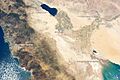
The Salton Trough region from orbit.

