
Salton Buttes facts for kids
Quick facts for kids Salton Buttes |
|
|---|---|
| Niland Field | |

Salton Buttes
Location in California
|
|
| Highest point | |
| Elevation | −40 m (−130 ft) |
The Salton Buttes are a cool group of volcanoes in California. You can find them right by the Salton Sea. They are actually five dome-shaped volcanoes lined up over about 7-kilometer (4.3 mi)! Their names are Mullet Island, North Red Hill, Obsidian Butte, Rock Hill, and South Red Hill.
These volcanoes are connected to areas with steam vents and hot springs. There might even be more volcanoes hidden deep underground! Long ago, people used to get a special volcanic glass called obsidian from Obsidian Butte. It was very important for making tools.
The Salton Buttes sit in a big dip in the land called the Salton Trough. This dip was formed by huge cracks in the Earth's crust, like the San Andreas Fault. This area is like a northern extension of the Gulf of California. It's a place where the Earth's crust is actively spreading apart, causing lots of volcanic and geothermal activity.
Scientists used to think the Salton Buttes were very old. But new studies show they are much younger! All of them formed more recently, during our current time period, called the Holocene epoch. They mostly grew from slow, oozing lava flows. It's possible these volcanoes could erupt again in the future, which could be dangerous for nearby areas.
Contents
Exploring the Salton Buttes
The Salton Buttes are on the southeast side of the Salton Sea. Their highest points are actually −40 m (−130 ft) below sea level! They are located in Imperial County. The towns of Niland and Calipatria are nearby. Palm Springs is about 140 kilometers (90 mi) to the northwest. The Alamo River flows into the Salton Sea right between these buttes. Sometimes, this whole area is called the "Niland Field."
What are the five buttes?
The Salton Buttes are five lava domes. They rise about 30–40 m (98–131 ft) above the land around them. Each one is less than 1 km (0.62 mi) wide. But together, they form a chain that is 7 km (4.3 mi) long.
From north to south, they are:
- Mullet Island (33°13′32″N 115°36′30″W / 33.22556°N 115.60833°W)
- North Red Hill (33°12′0″N 115°36′43″W / 33.20000°N 115.61194°W)
- South Red Hill (33°11′46″N 115°36′42″W / 33.19611°N 115.61167°W)
- Rock Hill (33°11′1″N 115°37′24″W / 33.18361°N 115.62333°W)
- Obsidian Butte (33°10′17″N 115°38′16″W / 33.17139°N 115.63778°W)
The Red Hills and Obsidian Butte are the biggest. The Red Hills are like two volcanoes joined by volcanic ash. They are also known as Red Island. In 2005, Red Island and Mullet Island were both actual islands. By 2018, Mullet Island had become a peninsula. Other domes have also been islands at different times. Waves have even carved out terraces along their old shorelines.
How did they form?
The Salton Buttes are lava domes. They formed when thick, gooey lava slowly pushed up from a volcanic vent. This vent was about 250 m (820 ft) wide. Obsidian Butte is surrounded by old lava flows. Mullet Island has a cool "onion-skin" pattern on its surface.
On Red Hill, there's a quarry, a marina, and a trailer park. Obsidian Butte has been heavily quarried, meaning a lot of its rock has been dug out. This has changed its original look quite a bit. You can also find hot springs and gas vents on Mullet Island.
Steam and Mud Volcanoes
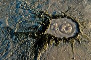
A field of fumaroles (steam vents) is found near the Salton Buttes. This field has gryphons and salses. Gryphons are small mud volcanoes, less than 3 m (9.8 ft) tall. These vents release carbon dioxide and steam, along with ammonia and hydrogen sulfide. Some of these vents can reach 2 m (6.6 ft) high! They look a bit like mini lava-erupting volcanoes. You can also find Mud pots, which are bubbling pools of mud.
Some parts of this field have appeared as the Salton Sea's water level has dropped. This drop has also made the steam vents grow bigger and more noticeable. More gryphons have appeared too!
Geothermal Power
There's a huge geothermal field linked to the Salton Buttes. It's one of the biggest and hottest on Earth! Temperatures can reach 360 °C (680 °F) at depths of 1.5–2.5 km (0.93–1.55 mi). Scientists have found different types of volcanic rocks when drilling here. These include andesite, basalt, dacite, and rhyolite. Some of these rocks show signs of being changed by hot water. In some places, these volcanic rock layers are 100 m (330 ft) thick.
There might be other volcanoes buried under the ground here. Special surveys have found signs of at least four hidden volcanoes. This area is used to generate geothermal power. Currently, ten power plants produce 327 Watt[convert: unknown unit] of electricity!
-
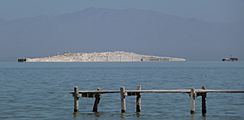
Mullet Island
-
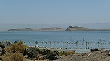
Obsidian Butte
-
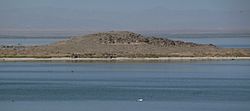
Red Island (center, reddish, low-lying) and Rock Hill (taller, steep dark knob at peak)
-
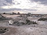
Mud volcanoes close to the Salton Buttes. Center, a gryphon; left foreground, part of a salse
-
A salse bubbling carbon dioxide
-
A mudpot bubbling hydrogen sulfide


How the Earth Works Here
Since a time called the Pliocene (millions of years ago), the Salton Trough and the Gulf of California have been an active rift zone. A rift zone is where the Earth's crust is pulling apart. This causes new seafloor spreading, volcanic activity, hot springs, and lots of sedimentation (layers of dirt and rock building up).
About five million years ago, the Colorado River Delta built up so much sediment that it separated the Salton Trough from the actual Gulf of California. This created a large low area that is now 40 m (130 ft) below sea level. This low area is called a pull-apart basin. It formed between different parts of the San Andreas Fault and the San Jacinto Fault. The Salton Trough is still sinking today, about 3 mm/a (0.12 in/year) each year. In the middle, it sinks even faster, up to 4–8 mm/a (0.16–0.31 in/year) annually.
Many volcanoes have formed in this region over the last 2.6 million years. These include Cerro Prieto, Consag Rock, and the Salton Buttes. There's also strong geothermal activity. The Salton Trough alone has five major geothermal fields. These fields produce a lot of heat, some of which is used to make geothermal power.

The Salton Buttes volcanoes grew on top of young sediments from the Colorado River Delta. Deep below them, the basement rock is made of old lake and river sediments. These include mudstones and sandstones. Even deeper, there are metamorphic rocks, which are rocks changed by heat and pressure. Below that, at 18–10 km (11.2–6.2 mi) depth, are gabbroic rocks.
All the Salton Buttes, except Mullet Island, sit on a straight line feature. This line has a strong magnetic signal, which might mean there are buried volcanoes. The volcanoes seem to share a common dyke (a sheet of rock that formed in a crack). This dyke might be connected to deeper processes where the Earth's crust is stretching. Scientists are still figuring out where the heat for these volcanoes and hot springs comes from.
What are the rocks made of?
The domes are made of a type of volcanic rock called rhyolite. This rock is rich in potassium and low in calcium. You can find tiny crystals in the rhyolite, like quartz and zircon. The rocks here are different from the sediments in the Salton Trough. All the domes together make up about 0.5 km3 (0.12 cu mi) of rock.

Obsidian from Obsidian Butte has been found at old archeological sites far away. It has been found in the Colorado Desert, across San Diego County, and even in northern Mexico. Before Obsidian Butte formed, people used obsidian from the Coso Volcanic Field. Once Obsidian Butte appeared, people started using its obsidian instead. This shows how important it was!
Scientists are still debating how the magma (molten rock) for these volcanoes formed. It could be from different processes, like rocks melting or changing deep underground. One idea is that there's a constantly active magma chamber deep down. This chamber sends magma up to a shallower chamber, where the rhyolite forms.
Sometimes, you can find pieces of other rocks inside the volcanic rocks. These are called xenoliths. They include granite and basalt. Some of these basalts are similar to rocks found in active rift zones like the Gulf of California.
When did they erupt?
Most of the Salton Buttes formed between 1,800 and 2,300 years ago. Mullet Island might be even older, perhaps 5,000 years old. According to the Global Volcanism Program, Mullet Island formed around 290 BCE (Before Common Era). Obsidian Butte formed around 10 CE (Common Era), and the other Buttes around 210 CE. If Mullet Island formed at the same time as the others, the eruptions that created the Salton Buttes lasted less than 500 years. Today, you can still see steam coming from cracks in the rocks. There is also earthquake activity from the geothermal field.
How we know their age
Scientists have used different methods to figure out the age of the Salton Buttes. Early tests on Obsidian Butte suggested it was much older, but these estimates were later updated. Newer methods, like dating zircon crystals, showed that the volcanoes are much more recent. This was also supported by the fact that the domes are small and would have been buried by sediments if they were too old. Also, obsidian from Obsidian Butte is only found in archeological sites from recent times.
Other dating methods also showed recent ages. For example, Obsidian Butte might be as young as 490 BCE. Knowing the exact age of Obsidian Butte is important for archeologists. If they find Obsidian Butte glass at a site, they know the site must be from after the volcano erupted. Obsidian Butte and Red Hill probably formed very close in time, less than five centuries apart.
How the eruptions happened
The domes formed mostly from effusive eruptions, where lava oozes out slowly. But at least Obsidian Butte and South Red Hill also had explosive eruptions. These explosive eruptions happened before the lava oozed out. They left behind pumice and tephra (volcanic ash), which have been found in drill holes and even quarried.
After they formed, the Salton Buttes were sometimes covered by Lake Cahuilla. This created wave-cut terraces on their sides. It also made the obsidian at Obsidian Butte hard to reach. Only South Red Hill seems to have erupted underwater. Floating rafts of pumice formed on the lake and can still be seen on its old shorelines. Wind and lake sediments also settled on the domes.
What are the dangers?
Finding out that the Salton Buttes erupted recently in the Holocene has made people pay more attention to the dangers they pose. The California Volcano Observatory watches the Salton Buttes for any signs of future volcanic activity. Scientists have found evidence that liquid magma is still present deep under the buttes.
Because these volcanoes have erupted before, and there are signs of activity now, they are considered high-hazard volcanoes. Many people live nearby (about 2,518 people in 2010). Future eruptions could produce dangerous pyroclastic flows (fast-moving hot gas and rock) and pyroclastic surges. These could endanger people within ten kilometers (6.2 mi) of the vents. The area is monitored with seismometers (which detect earthquakes) and by checking the gases from hot springs. There is a volcano hazard map, but it's still being improved.
