Holtville, California facts for kids
Quick facts for kids
City of Holtville
|
||
|---|---|---|

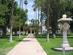
Holtville City Hall
|
||
|
||
| Motto(s):
"The Carrot Capital of the World"
|
||

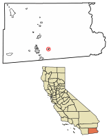
Location of Holtville in Imperial County, California.
|
||
| Country | United States | |
| State | California | |
| County | Imperial | |
| Incorporated | July 1, 1908 | |
| Area | ||
| • Total | 1.16 sq mi (3.00 km2) | |
| • Land | 1.15 sq mi (2.99 km2) | |
| • Water | 0.01 sq mi (0.01 km2) 0.40% | |
| Elevation | -10 ft (-3 m) | |
| Population
(2020)
|
||
| • Total | 5,605 | |
| • Density | 4,832/sq mi (1,868/km2) | |
| Time zone | UTC-8 (Pacific (PST)) | |
| • Summer (DST) | UTC-7 (PDT) | |
| ZIP code |
92250
|
|
| Area codes | 442/760 | |
| FIPS code | 06-34246 | |
| GNIS feature IDs | 1660761, 2410780 | |
Holtville is a city in Imperial County, California. It is sometimes called "The Carrot Capital of the World." Holtville is located about 10.5 miles (17 km) east of El Centro. In 2020, about 5,605 people lived there.
Contents
History of Holtville
Holtville was first settled in the 1880s by people from Switzerland and Germany. Many of them came from Mexico. The city was originally named Holton.
How Holtville Got Its Name
The city was founded in 1903 by a person named W.F. Holt. It became an official city on July 1, 1908. The name was changed to Holtville because the U.S. Postal Service thought "Holton" sounded too much like Colton. Colton was an important railroad town nearby. The new name, Holtville, honors the founder, W.F. Holt.
Growth and Development
Over the years, Holtville grew thanks to new transportation routes.
- In the 1890s, railroads were built, connecting the city to other places.
- The All-American Canal was built in the late 1940s. This canal brought water to the area, which helped farming.
- Major roads like U.S. Route 80 (now part of Interstate 8) were built in the 1920s and 1970s.
- The North American Free Trade Agreement (NAFTA) in the 1990s also helped the local economy.
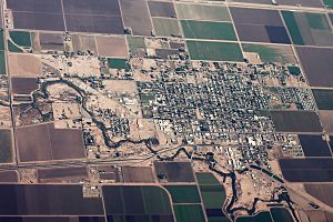
The city is located on the northeast bank of the Alamo River. This river is one of two rivers that flow north from Mexico into Imperial County.
Geography and Climate
Holtville covers about 1.1 square miles (3.0 square kilometers) of land. Only a tiny part of it is water.
Holtville's Climate
Holtville has a desert climate. This means it gets a lot of sunshine all year round. The weather is usually dry and warm. On climate maps, this type of weather is called "Bwh."
Population Information
Holtville's population has changed over the years.
| Historical population | |||
|---|---|---|---|
| Census | Pop. | %± | |
| 1910 | 729 | — | |
| 1920 | 1,347 | 84.8% | |
| 1930 | 1,758 | 30.5% | |
| 1940 | 1,772 | 0.8% | |
| 1950 | 2,472 | 39.5% | |
| 1960 | 3,080 | 24.6% | |
| 1970 | 3,496 | 13.5% | |
| 1980 | 4,399 | 25.8% | |
| 1990 | 4,820 | 9.6% | |
| 2000 | 5,612 | 16.4% | |
| 2010 | 5,939 | 5.8% | |
| 2019 (est.) | 6,621 | 11.5% | |
| U.S. Decennial Census | |||
Population in 2010
In 2010, Holtville had 5,939 people. About 31.2% of the people were under 18 years old. About 12.3% were 65 years or older. The average age in Holtville was 32.1 years.
Population in 2000
In 2000, there were 5,612 people living in Holtville. About 35.2% of the people were under 18 years old. About 11.1% were 65 years or older. The average age in Holtville was 30 years.
Arts and Culture
Annual Carrot Festival
Holtville's biggest yearly event is the Carrot Festival. It happens in late January or early February. The festival usually lasts for 10 days and includes a parade, a carnival, and other fun activities. Holtville became famous for its Carrot Festival in the mid-20th century. Some people even confused it with the "Coachella Valley" name from a Bugs Bunny cartoon. In the cartoon, Bugs Bunny reads a map looking for a "Carrot Festival."
Local Media
Holtville has its own weekly newspaper called The Holtville Tribune. It is delivered by mail and sold at newsstands in the area. Another newspaper, the Imperial Valley Press, is a daily paper from El Centro.
City Infrastructure
Transportation in Holtville
The old U.S. Route 80 used to run through the middle of Holtville on Fifth Street. A small monument in Holt Park shows the distances to different places. This old route is now part of State Route 115. Most of the main traffic now uses Interstate 8, which is about 2.5 miles south of Holtville. You can easily get to Holtville from Interstate 8 using the Orchard Road exit. A newer road, State Route 7, connects Holtville to factories and industrial areas in Mexicali, Mexico.
Holtville was once connected by a railroad to El Centro. However, this line and another one going north are no longer used. When the railroad station closed, it caused some economic challenges for the town.
Police Services
Holtville used to have its own police department. Now, police protection for the city is provided by the Imperial County Sheriff's Department.
City Services
The city of Holtville provides its own water and sewer services. Trash collection is handled by CR&R. Other important services like gas, electricity, and internet are provided by companies such as Southern California Gas, Imperial Irrigation District, AT&T California, and Spectrum.
Pete Mellinger Alamo River Trail
A walking and biking trail was built in the 2010s. It starts near Evan Hewes Highway and ends at the Holtville Skatepark. This trail is named after Pete Mellinger, who was a city planning commissioner.
Holtville in Books and Movies
The 1911 novel and the 1926 silent film, The Winning of Barbara Worth, were set and filmed in the Holtville area.
Notable People from Holtville
- Daniel Everett (born 1951): He is an American linguist. He is known for studying the Pirahã people and their unique language in the Amazon Basin. Daniel Everett was born and grew up in Holtville.
- George E. Brown Jr. (1920–1999): He was a U.S. Member of Congress for many years. He was known for supporting civil rights, science, space exploration, public schools, and protecting the environment. He was born and spent his early years in Holtville.
See also
 In Spanish: Holtville (California) para niños
 | Sharif Bey |
 | Hale Woodruff |
 | Richmond Barthé |
 | Purvis Young |


