
All-American Canal facts for kids

The All-American Canal is a very important waterway in southeastern California. It is about 82 miles (132 km) long. This canal brings water from the Colorado River to the Imperial Valley and nine cities. It is the only source of water for the Imperial Valley. The canal replaced an older one called the Alamo Canal, which was mostly in Mexico.
The Imperial Dam, located about 30 miles (48 km) northeast of Yuma, Arizona, sends water into the All-American Canal. The canal then runs west towards Calexico, California. From there, several smaller canals branch off. These canals help water over 630,000 acres (250,000 hectares) of farmland. This has helped the Imperial Valley, which was once a very dry desert, grow many crops.
The All-American Canal is one of the largest irrigation canals in the world. It can carry a huge amount of water, up to 26,155 cubic feet (740.6 cubic meters) per second. Water that runs off from the farms irrigated by the canal flows into the Salton Sea.
Because of its strong currents, the canal can be very dangerous. Many people have drowned in it since it was built. It's also important to know that fish caught in the canal might have high levels of certain chemicals. Because of this, it is not safe to eat them.
Contents
How the Canal Was Built

The idea for the All-American Canal came about with the Hoover Dam. Both were approved by a law in 1928. The canal was built in the 1930s by the United States Bureau of Reclamation. A company called Six Companies, Inc. also helped.
A chief engineer named John L. Savage oversaw its design and building. The canal was finished in 1942. In 2016, the canal was recognized as a special National Historic Civil Engineering Landmark. This award came from the American Society of Civil Engineers.
How the Canal Works


Watering Farmlands
The United States Bureau of Reclamation owns the canal. However, the Imperial Irrigation District is in charge of running it. Water for the canal is taken from the Imperial Diversion Dam.
The All-American Canal feeds several smaller canals. These include the Coachella Canal, East Highline Canal, Central Main Canal, and Westside Main Canal. These main branches and other smaller canals spread the water. The main canal is 82 miles (132 km) long. It drops about 175 feet (53 meters) in height along its path. The canal is between 150 feet (46 meters) and 700 feet (213 meters) wide. Its depth ranges from 7 feet (2.1 meters) to 50 feet (15 meters). The canals get smaller as they go west because they carry less water.
Making Electricity
There are eight hydroelectric power plants along the All-American Canal system. These plants use the force of falling water to create electricity. Drops 1 through 5, Pilot Knob, East Highline, and Double Weir are all on the All-American Canal. Another power plant, Turnip, is on the Central Main Canal branch.
These power plants are not very big. Together, they can produce 58 megawatts of electricity. They make electricity based on how much water is needed for farms and cities. There is also a 7.2-megawatt pumped storage plant at Senator Wash Dam. This plant releases water when more water is needed than what flows from Parker Dam.
Water Flowing to the Salton Sea
Water that runs off from the farms irrigated by the All-American Canal forms most of the flow in the Alamo River and New River. Both of these rivers drain into the Salton Sea. This runoff now provides most of the water for the Salton Sea. In the past, the Salton Sea would sometimes flood from the Colorado River. It would then usually dry up before flooding again. If it weren't for the All-American Canal, the Salton Sea would likely have dried up a long time ago.
The canal system carries tiny bits of dirt, minerals, and salts from the Colorado River into the Salton Sea. The Salton Sea has no outlet to the ocean. This means that as water evaporates, these salts and minerals become more and more concentrated.
The All-American Canal Lining Project
A lot of water, about 68,000 acre-feet (84 million cubic meters), used to leak from the All-American Canal each year. This was especially true where the canal crossed the large Algodones Dune Field. About 90% of this leaking water went into Mexico. At first, this leakage caused floods. But people in the Mexicali Valley built systems to collect this water. Over time, farms in the Mexicali Valley started to rely on this leaking water for irrigation.
As more water was used in both rural and city areas, this leakage became a problem. The All-American Canal Lining Project was started to fix this. It was part of California's plan for using Colorado River water. The project lined about 37 kilometers (23 miles) of the canal to stop the leaks.
Construction on this project began in 2007 and was finished in 2009. The Imperial Irrigation District built a new canal right next to the old one. Water was then sent into this new, lined canal. This helped save a lot of water that was previously lost.
See Also
Images for kids
-
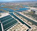
The Imperial Dam, where the canal's water comes from.
-
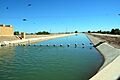
A part of the canal, showing its steep concrete sides and buoys to help prevent drownings.
-
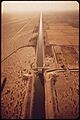
A straight section of the canal.


