Pilot Knob (Imperial County, California) facts for kids
Quick facts for kids Pilot Knob |
|
|---|---|

(at center-left)
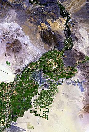
The Cargo Muchacho Mountains surrounded by alluvial fans. The small outlier "small mountain peak", due-south, is Pilot Knob. (The line appearing adjacent, is the All American Canal to the El Centro agriculture region.) |
|
| Highest point | |
| Elevation | 876 ft (267 m) NAVD 88 |
| Geography | |
| Topo map | USGS Yuma West |
| Geology | |
| Mountain type | Volcanic plug |
Pilot Knob is a mountain peak in Imperial County, California. It's also known by other names like Avie Quah-la-Altwa. It's about 8 miles (13 km) southeast of Ogilby. The peak stands about 876 feet (267 meters) tall.
Pilot Knob is a rocky hill located west of Yuma, Arizona and Winterhaven, California. It's connected to the Cargo Muchacho Mountains, which are about 7 miles (11 km) to the north. This peak was named Pilot Knob because it was an important landmark. Riverboats used it to find their way on the Colorado River in the 1800s and 1900s. Today, Pilot Knob is a special area managed by the Bureau of Land Management. It is called an Area of Critical Environmental Concern.
What is Pilot Knob?
Pilot Knob is a type of landform called a Volcanic plug. This means it's made from hardened lava that once filled the vent of an ancient volcano. Over time, the softer rock around it wore away, leaving the harder volcanic rock standing tall.
This rocky hill is about 7 miles (11 km) away from the main Cargo Muchacho Mountains. It sits at the bottom of large piles of sand and gravel called alluvial fans. The entire mountain area is about 2 miles (3.2 km) wide and 2 miles (3.2 km) long. You can see a rock quarry on the north side of the mountain from Interstate 8.
Getting to Pilot Knob
You can reach Pilot Knob from Interstate 8. The mountain is located east of the Algodones Dunes. It is also east of El Centro, California in southeastern Imperial County.
The All-American Canal passes right by the south side of Pilot Knob. This canal carries water for farming. You can see it from above as it crosses the Algodones Dunes to the west.
Pilot Knob's History
In 1774, explorer Juan Bautista de Anza saw this peak. He named it Cerro de San Pablo. A mission called the Saint Thomas Yuma Indian Mission was located about 8 miles (13 km) to the east.
During the California Gold Rush, Pilot Knob was a very important landmark. It helped travelers find their way on the Southern Emigrant Trail. This trail led to a major crossing point on the Colorado River near what is now Yuma, Arizona. In 1858, the Butterfield Overland Mail set up a station near the river and Pilot Knob.
The Alamo Canal also had its water intake at Pilot Knob. This was because the mountain provided a strong, rocky base for the canal's head gate. From 1953 to 1970, a TV station named KIVA (TV) in Yuma, Arizona, broadcasted from Pilot Knob.
 | Tommie Smith |
 | Simone Manuel |
 | Shani Davis |
 | Simone Biles |
 | Alice Coachman |


