Cargo Muchacho Mountains facts for kids
Quick facts for kids Cargo Muchacho Mountains |
|
|---|---|

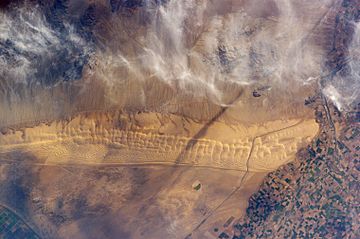
Cargo Muchacho Mountains and the Algodones Dunes from space. The mountain range is in the upper portion of the image, beneath the clouds
(dunefield: ~13 x 65 mi) |
|
| Highest point | |
| Elevation | 2,219 ft (676 m) NAVD 88 |
| Geography | |
| Country | United States |
| State | California |
| District | Imperial County |
| Range coordinates | 32°52′5.159″N 114°46′48.854″W / 32.86809972°N 114.78023722°W |
| Topo map | USGS Ogilby |
The Cargo Muchacho Mountains are a mountain range in the United States. You can find them in the southeastern part of the Colorado Desert. They are located in Imperial County, California, near the Colorado River. A geologist named John T. Dillon studied the rocks and landforms here.
Where Are They?
The Cargo Muchacho Mountains stretch from northwest to southeast. They are located southeast of the Imperial Valley. The mountains are also northwest of the Colorado River and the cities of Yuma, Arizona and Winterhaven, California.
Nearby Landmarks
To the south and southeast of these mountains are the Chocolate Mountains. East of the Cargo Muchacho Mountains, you will find the large Algodones Dunes.
South of the range is Pilot Knob. This is a special landmark peak. It was formed by a volcanic plug, which is hardened lava from an old volcano.
What Can You Find There?
These mountains were once home to several important mines. These include the American Girl Mine, the Golden Bee Mine, and the Cargo Mine. People used to dig for valuable minerals in these areas.
The All-American Canal
The All-American Canal passes just south of the mountain range. This canal is very important. It brings water from the Colorado River to farms and cities in California. It helps make the desert land useful for growing crops.
See also
 In Spanish: Sierra de Cargo Muchacho para niños
 | Bayard Rustin |
 | Jeannette Carter |
 | Jeremiah A. Brown |


