
Image: Map of the Gila Trail.pdf

Size of this JPG preview of this PDF file: 776 × 600 pixels. Other resolution: 311 × 240 pixels.
Original image (1,650 × 1,275 pixels, file size: 154 KB, MIME type: application/pdf)
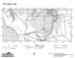
Description: Map of the Gila Trail—Southern Emigrant Trail. A 19th century westward expansion route/wagon trail for Euro-American immigration into southwestern North America (1849 - 1860s). In present day Southwestern United States and Northwestern Mexico.
Usage Terms: Public domain
Image usage
The following page links to this image:

All content from Kiddle encyclopedia articles (including the article images and facts) can be freely used under Attribution-ShareAlike license, unless stated otherwise.