
Baja California (state) facts for kids
Quick facts for kids
Baja California
|
|||
|---|---|---|---|
|
|||
 |
|||
| Country | |||
| Capital | Mexicali | ||
| Municipalities | 5 | ||
| Largest City | Tijuana | ||
| Area
Ranked 12th |
|||
| • Total | 69,921 km2 (26,997 sq mi) | ||
| Population
(2005)
|
|||
| • Total | 2,844,469 (Ranked 14th) | ||
| HDI (2004) | 0.8233 - high Ranked 7th |
||
| ISO 3166-2 | MX-BCN | ||
| Postal abbr. | B.C. | ||
| Website | State government | ||


Baja California is a state in Mexico. It's located at the northern part of the Baja California peninsula. To its south is the state of Baja California Sur. To its east is Sonora. It also shares a border with the U.S. state of California in the north. The name "Baja California" means "Lower California."
This state is the furthest north and furthest west state in Mexico.
Contents
History of Baja California
The first people arrived in the Baja California peninsula at least 11,000 years ago. There were two main groups of native people. In the south were the Cochimí. In the north were groups like the Kiliwa, Paipai, Kumeyaay, Cocopah, and Quechan. These groups lived in different ways. Some were hunter-gatherers, moving often to find food. Others, especially in the northwest, lived in one place and had larger populations. Some groups near the Colorado River even farmed.
Another group, the Guachimis, came from the north. They created many amazing cave paintings in the Sierra de Guadalupe. We don't know much about them. They lived there from about 100 BC until Europeans arrived. Their rock art is now a World Heritage site.
European Arrival and Missions
Europeans first reached Baja California in 1539. Francisco de Ulloa explored the east coast and part of the west coast. In 1540, Hernando de Alarcón explored the Colorado River. Juan Rodríguez Cabrillo finished exploring the west coast in 1542. Later, Sebastián Vizcaíno surveyed the west coast again in 1602.
The Jesuits started the first lasting colony in 1697 at Loreto. Over the next years, they built missions across the southern part of the peninsula. In the 1750s, Ferdinand Konščak explored northward into what is now Baja California. Jesuit missions were then built in the north for the Cochimí people. These included Santa Gertrudis (1752), San Borja (1762), and Santa María (1767).
In 1768, the Jesuits left. The Franciscans took over for a short time (1768–1773). They built one new mission at San Fernando Velicatá. An important expedition in 1769, led by Gaspar de Portolá and Junipero Serra, explored the northwestern part of the state.
The Dominicans took over the missions in 1773. They built new missions for the northern Cochimí and Yuman peoples. These missions stretched from El Rosario (1774) to Descanso (1817), which is just south of Tijuana.
Important Dates in History
- 1804: The Spanish colony of California was split into "Upper" (Alta) and "Lower" (Baja) California. This division was based on where the Franciscan and Dominican missions were.
- 1848: Alta California became part of the United States.
- 1853: An American soldier named William Walker tried to take over Baja California. He declared himself president but was forced to leave after a few months.
- 1930: Baja California was divided into Northern and Southern territories.
- 1952: The Northern Territory of Baja California became the 29th state of Mexico. It was named Baja California. The southern part remained a federal territory.
- 1974: The Southern Territory of Baja California became the 31st state, Baja California Sur.
- 1989: Ernesto Ruffo Appel became the first governor from a different political party (PAN) in Baja California. He was the first opposition governor in any Mexican state since the Mexican Revolution.
Geography of Baja California


Baja California has many different types of land, even though it's not a very large state. The Peninsular Ranges of mountains run through the middle of the state. The most important mountain ranges are the Sierra de Juarez and the Sierra de San Pedro Mártir. These mountains have forests that look like those in Southern California. Picacho del Diablo is the highest point in the entire peninsula.
Between the mountain ranges are valleys with good climates for farming. The Valle de Guadalupe and Valle de Ojos Negros are examples. These areas grow citrus fruits and grapes. The mountains continue south to the Gulf of California.
The Pacific Ocean brings cool winds, and the cold California Current makes the weather along the northwest coast nice all year. Because of this current, rain from the north doesn't reach the southern areas much, making them drier. South of the El Rosario River, the land changes from a Mediterranean style to a desert. This desert has many types of succulent plants that grow well, partly because of the coastal fog.
To the east, the Sonoran Desert stretches into the state from California and Sonora. Some of the hottest temperatures in Mexico are found near the Mexicali Valley. However, with water from the Colorado River, this area has become a major farming region. The Cerro Prieto geothermal area near Mexicali produces about 80% of the state's electricity. It even makes enough to sell to California. Laguna Salada is a salty lake below sea level, located near Mexicali.
There are many islands off the Pacific coast. Guadalupe Island is far to the west and has large groups of sea lions. Cedros Island is in the southwest. The Todos Santos Islands and Coronado Islands are near Ensenada and Tijuana. All the islands in the Gulf of California that are on the Baja California side belong to the municipality of Mexicali.
Baja California gets most of its water from the Colorado River. In the past, the river flowed into the Colorado River Delta and then into the Gulf of California. But now, a lot of water is used in the Southwestern United States, so less water reaches the Gulf. The Tijuana metropolitan area also uses water from the Tijuana River. Many rural areas in Baja California rely on wells and a few dams for water. Tijuana also buys water from San Diego County in California. Getting enough clean water is the biggest natural resource challenge for the state.
Climate Zones
Baja California has different climates, from Mediterranean to desert. The Mediterranean climate is in the northwest. Here, summers are dry and mild, and winters are cool and rainy. This climate is found from Tijuana to San Quintin and in nearby inland valleys. The cold California Current often creates a low fog near the coast.
As you go up into the Sierra de Baja California mountains, the climate becomes alpine. Summers are cool, and winters can be very cold, with temperatures below freezing at night. It often snows in the Sierra de Juarez and Sierra de San Pedro Martir from December to April. The mountains get more rain than the coastal or desert areas. You can find pine, cedar, and fir forests in these mountains.
The east side of the mountains is very dry because the mountains block the rain. This creates an extremely arid (dry) environment. The Sonoran Desert part of Baja California has hot summers and mild winters with almost no frost. The Mexicali Valley is below sea level and has the highest temperatures in Mexico. Temperatures often go above 47°C (117°F) in mid-summer, and have even gone over 50°C (122°F) sometimes.
Further south along the Pacific coast, the Mediterranean climate changes into a desert climate. But it's milder and not as hot as the desert along the Gulf coast. You can find these changing climates from San Quintin to El Rosario. Further inland and along the Gulf of California, there are fewer plants, and summer temperatures are very high. The islands in the Gulf of California also have a desert climate. Some oases (green areas with water) can be found in the desert, where small towns like Catavina, San Borja, and Santa Gertrudis are located.
Plants and Animals
Common trees in Baja California include the Jeffrey pine, Sugar pine, and Pinyon pine. Smaller plants like Manzanita also grow here. Many reptiles live in the state, such as the Western fence lizard. The fish group Bajacalifornia is named after the Baja California Peninsula.
In the main wildlife areas, like Constitution 1857 National Park and Sierra de San Pedro Mártir National Park, you can find several types of pine trees. These include Jeffrey pine, Ponderosa pine, Mexican Pinyon, Parry pinyon, and Single-leaf pinyon. Other plants like Juniper and chaparral also grow here.
The animals in these parks include many mammals. You might see mule deer, bighorn sheep, cougars, bobcats, ringtail cats, coyotes, rabbits, and squirrels. There are also more than 30 kinds of bats. Many birds live here too, such as the bald eagle, golden eagle, falcon, woodpecker, black vulture, crow, and different types of nuthatches and ducks.
2010 Earthquakes
On Easter Sunday, April 4, 2010, a strong earthquake hit the Mexicali Valley. It happened at 3:40 PM PDT and had a magnitude of 7.2. The center of the earthquake was about 26 kilometers (16 miles) southwest of the city of Guadalupe Victoria, Baja California. People felt the main earthquake as far away as Los Angeles, Las Vegas, Phoenix, and Tucson.
After the main shock, there were at least six smaller earthquakes, called aftershocks. These aftershocks had magnitudes between 5.0 and 5.4. One of them, a 5.1-magnitude quake, happened at 4:14 AM the next day near El Centro. Sadly, two people were confirmed to have died because of the earthquake.
Images for kids
-
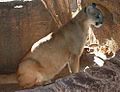
Mountain Lion
-
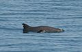
Vaquita Olson
-
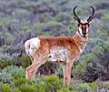
Antilocapra american
-
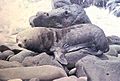
Arctocephalus townsendi
-
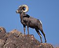
Desert Bighorn Sheep
-
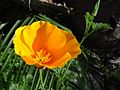
California poppy
-
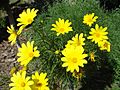
Coreopsis gigantea
-
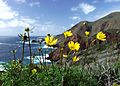
Encelia californica growing on the Ensenada Municipality coast, typical of the California coastal sage and chaparral ecoregion
-
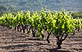
Vineyard in the Valle de Guadalupe
-
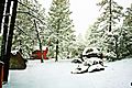
Snowfall at Constitution 1857 National Park
-
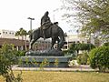
Los Pioneros monument in Mexicali, dedicated to the pioneers that settled the region
-
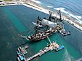
Filming of Master and Commander at Baja Film Studios. Located in Rosarito, Baja Film Studios has become one of the premier production facilities with horizon tanks.


See also
 In Spanish: Baja California para niños
