
Hurricane Nora (1997) facts for kids
| Category 4 major hurricane (SSHWS/NWS) | |

Hurricane Nora shortly after peak strength on September 22, 1997
|
|
| Formed | September 16, 1997 |
|---|---|
| Dissipated | September 26, 1997 |
| Highest winds | 1-minute sustained: 130 mph (215 km/h) |
| Lowest pressure | 950 mbar (hPa); 28.05 inHg |
| Fatalities | 2 direct, 4 indirect |
| Damage | $100 million (1997 USD) |
| Areas affected | Baja California, Southwestern United States |
| Part of the 1997 Pacific hurricane season | |
Hurricane Nora was a powerful storm that formed in the Pacific Ocean in September 1997. It was important because it was the first hurricane since 1976 to seriously threaten the Continental United States. Nora brought strong winds and heavy rains to parts of Mexico and the United States.
Contents
Nora's Journey Begins
Hurricane Nora started as a tropical wave on September 16, 1997. This wave helped form another hurricane, Erika, in the Atlantic. But in the Pacific, it became Tropical Depression 16-E on the same day. Soon after, it grew into Tropical Storm Nora.
On September 18, Nora became a hurricane. It was moving northwest in an area that helped it get stronger. However, it then slowed down over cooler water. This made the hurricane a bit weaker for a short time.
Reaching Peak Strength
Nora started moving again on September 20. It quickly gained strength and reached its strongest point on September 21 and 22. At its peak, Nora had winds of 115 knots (about 132 miles per hour) and a central pressure of 950 millibars. This made it a very powerful storm.
After its peak, Nora moved over an area where Hurricane Linda had passed earlier. This caused Nora to weaken down to a Category 1 hurricane.
Heading Towards Land
During this time, a weather system called a trough formed. This trough changed Nora's path, turning it towards the northeast. This new path led Nora over warmer waters, helping it regain some strength.
Nora then headed straight for the Baja California area. It made landfall twice as a Category 1 hurricane. The first time was near Punta Eugenia, and the second was south of San Fernando.
Nora's Impact in Mexico
Hurricane Nora caused serious damage and sadly, two people died in Mexico. One person was killed by a fallen power line in Mexicali. Another person died while scuba diving due to strong underwater currents.
The storm caused a lot of damage to homes. Many houses were ruined by strong waves. In San Felipe, about 350 to 400 people lost their homes. In Puerto Peñasco, the strong winds ripped roofs off houses and pulled trees out of the ground.
Nora Reaches the United States
After hitting Mexico, Nora moved into the United States. It was still a tropical storm when it crossed the border into California and Arizona. In Yuma, people reported strong gale-force winds.
The storm brought very heavy rains to the desert areas. In some places, the amount of rain Nora brought was more than what they usually get in a whole year! Nora weakened to a tropical depression while it was over California. It finally disappeared on September 26.
Damage in the United States
No one in the United States was directly killed by Nora. However, the California Highway Patrol said that several traffic accidents that caused deaths were due to the bad weather.
Thousands of people in California and Arizona lost electricity. In Seeley, 16 telephone poles were knocked down. Streets flooded in cities like San Diego, Indio, El Centro, and Palm Springs. Even in Utah, the storm's leftover energy damaged trees and three homes.
The total damage from Nora was very high. It was estimated to be several hundred million dollars. Lemon trees alone suffered about 40 million dollars in damage.
Preparing for the Storm
People in the United States took steps to get ready for Hurricane Nora. On September 24, the Governor of Arizona, Jane Dee Hull, started an emergency center. This was to prepare for possible flash flooding on the dry desert ground.
In Yuma, residents filled about 55,000 sandbags to help stop flooding. The state's National Guard was also called in. They sent drinking water and electric generators to Yuma.
The National Weather Service also warned people about flash floods. These warnings were for western Arizona, southeastern California, southwestern Colorado, southern Nevada, and southern Utah.
Rainfall and Flooding
Hurricane Nora brought a lot of rain. Radar showed that some areas along the northern Gulf of California coast of Baja California received about 10 inches (250 mm) of rain.
In the United States, the most rain was recorded in the Harquahala Mountains in Arizona. They got almost 12 inches (300 mm) of rain from Nora. This caused flash floods in western Arizona.
Near Phoenix, the heavy rain caused a small earthen dam called the Narrows Dam to break. In other places across Arizona, California, Nevada, and Utah, some areas received more than 3 inches (75 mm) of rain. This was sometimes as much as their entire yearly average rainfall.
Flooding was also reported in places like Somerton, San Diego, El Centro, Palm Springs, and Indio. About 12,000 people lost power in Yuma, Los Angeles, and southwestern Utah.
Nora's Name
Despite the damage it caused, the World Meteorological Organization decided not to remove the name Nora from the list of hurricane names. This means the name was used again in the 2003 Pacific hurricane season and is still on the list for future storms.
Images for kids
-
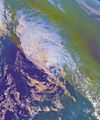
Hurricane Nora's remnants over the Southwestern United States
-
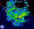
Hurricane Nora over northern Mexico as seen on Radar in Yuma, Arizona.
-
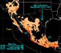
Nora Rainfall for Mexico and the United States


See also
 In Spanish: Huracán Nora (1997) para niños
