
1997 Pacific hurricane season facts for kids
The 1997 Pacific hurricane season was an incredibly active and powerful time for weather in the Eastern Pacific Ocean. It is remembered as one of the deadliest and most expensive seasons ever recorded. This happened because of a very strong weather event called El Niño. During this year, many powerful storms formed, including some that broke records for their strength and intensity.
Quick facts for kids 1997 Pacific hurricane season |
|
|---|---|

Season summary map
|
|
| Seasonal boundaries | |
| First system formed | June 1, 1997 |
| Last system dissipated | December 6, 1997 |
| Strongest storm | |
| Name | Linda |
| • Maximum winds | 185 mph (295 km/h) |
| • Lowest pressure | 902 mbar (hPa; 26.64 inHg) |
| Seasonal statistics | |
| Total depressions | 24 |
| Total storms | 19 |
| Hurricanes | 9 |
| Major hurricanes (Cat. 3+) |
7 |
| Total fatalities | 261–531 total |
| Total damage | $551 million (1997 USD) |
Contents
Overview of the 1997 Hurricane Season
The season officially began on May 15 in the eastern Pacific and June 1 in the central Pacific. It lasted until November 30. These are the dates when the ocean water is usually warm enough for storms to grow. In 1997, there were 24 tropical cyclones in total. Out of these, 19 became named storms, and 9 grew into hurricanes.
The Power of El Niño
A major reason for so much activity was the 1997–98 El Niño event. El Niño is a climate pattern where the water in the Pacific Ocean gets much warmer than usual. This warm water provides extra energy for storms. It also reduces wind shear (strong winds high in the sky that can blow a storm apart). With warm water and low wind shear, hurricanes can grow very large and powerful.
Key Statistics and Facts
The 1997 season was much busier than a normal year.
- Named Storms: 19 (The average is 15).
- Hurricanes: 9 (The average is 8).
- Major Hurricanes: 7 (The average is 4).
- Major hurricanes are storms that reach Category 3 or higher on the Saffir-Simpson scale.
Notable Hurricanes and Tropical Storms
Several storms during this season were famous for their size and the impact they had on land.
Hurricane Linda: The Record Breaker

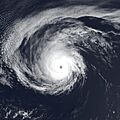
Hurricane Linda was the most powerful storm of the season. For many years, it held the record for the strongest hurricane ever seen in the Eastern Pacific. Its winds reached a staggering 185 mph (295 km/h). Luckily, Linda stayed mostly out at sea and did not hit land directly. However, it still caused big waves to crash onto the shores of Southern California.
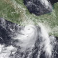
Hurricane Nora: A Rare Visitor to the Desert
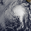
Hurricane Nora was unusual because it traveled very far north. After hitting Mexico, it moved into the United States as a tropical storm. It brought heavy rain and flooding to places that are usually very dry, like Arizona and California. It was the first time in over 20 years that a storm like this brought such strong winds to the Southwestern United States.
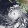
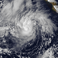
Hurricane Pauline: Impact on Mexico
Hurricane Pauline was the deadliest storm of the 1997 season. It hit the southern coast of Mexico in October. The storm brought huge amounts of rain to the mountains. This caused dangerous landslides and flooding in cities like Acapulco. Because of the damage it caused, the name Pauline was retired, meaning it will never be used to name a hurricane again.
Storms That Traveled Long Distances
Some storms were so long-lasting that they traveled across the International Date Line.
Crossing the International Date Line
Both Oliwa and Paka started as tropical storms in the Central Pacific. As they moved west across the ocean, they crossed the International Date Line. When a storm crosses this line, its name changes from a hurricane to a typhoon.
- Oliwa became a Super Typhoon and caused damage in Japan.
- Paka also became a Super Typhoon and caused major damage to the island of Guam in December.
How Scientists Measure These Storms
Scientists use a system called Accumulated Cyclone Energy (ACE) to see how active a season is. ACE looks at how strong the storms were and how long they lasted. The 1997 season had a very high ACE score, which confirms it was an "above-normal" year for weather activity.
Summary of Storm Names
Names are used to help people identify and track storms. In 1997, names like Andres, Blanca, and Carlos were used. If a storm is especially bad, its name is "retired" out of respect for the victims and to avoid confusion in the future.
- Pauline was retired after 1997.
- Paka was retired after it hit Guam.
Images for kids
-
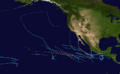
Map showing the paths of all storms in 1997.
-
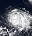
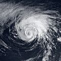
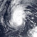
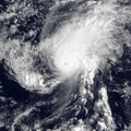
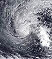
Hurricane Guillermo was another Category 5 storm.
-
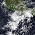
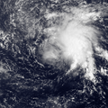
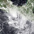
Hurricane Nora as it moved toward the Gulf of California.
-
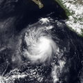
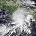
Hurricane Pauline near the coast of Mexico.
-
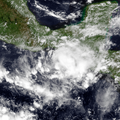
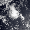
Tropical Storm Andres near Central America.
-
Satellite view of Tropical Storm Blanca.
-
Tropical Storm Carlos in the open ocean.
-
Hurricane Dolores at peak intensity.
-
Hurricane Enrique in the Eastern Pacific.
-
Hurricane Felicia showing a clear eye.
-
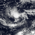
Tropical Storm Hilda.
-
Tropical Storm Ignacio near California.
-
Hurricane Jimena at sea.
-
Tropical Storm Oliwa before crossing the date line.
-
Tropical Storm Kevin.
-
Tropical Storm Marty.
-
Tropical Storm Olaf near the coast.
-
Hurricane Rick in November.
-
Tropical Storm Paka in the Central Pacific.


See also
 In Spanish: Temporada de huracanes en el Pacífico de 1997 para niños
- List of Pacific hurricane records
- Pacific hurricane season
- 1997 Atlantic hurricane season
- 1997 Pacific typhoon season
- 1997 North Indian Ocean cyclone season
- South-West Indian Ocean cyclone seasons: 1996–97, 1997–98
- Australian region cyclone seasons: 1996–97, 1997–98
- South Pacific cyclone seasons: 1996–97, 1997–98
