Blythe Intaglios facts for kids
Quick facts for kids |
|
|
Blythe Intaglios
|
|

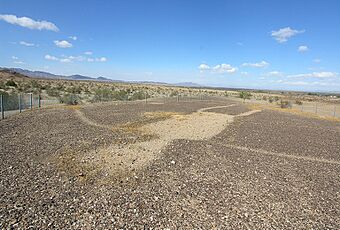
One of the Blythe Intaglios, 2007
|
|
| Nearest city | Blythe, California |
|---|---|
| NRHP reference No. | 75000452 |
| Added to NRHP | August 22, 1975 |
The Blythe Intaglios are giant drawings made on the ground near Blythe, California. These amazing figures are found in the Colorado Desert. People created these huge ground drawings, also called geoglyphs, a long time ago. We still don't know exactly why they made them.
These special drawings are located about 15 miles (24 km) north of Blythe. They are just west of U.S. Highway 95, close to the Colorado River. The Blythe Intaglios are the most famous of over 200 similar drawings in the Colorado Desert. This desert is the only place in North America where these kinds of desert ground drawings are found. Most of them are along the Colorado River.
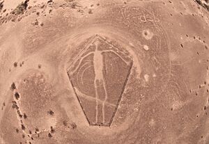
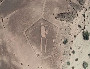
The Blythe Intaglios include three human figures, two animals with four legs, and a spiral shape. One researcher, Harner (1953), even reported two spirals. The largest human figure in this group is 171 feet (52 meters) long! These giant drawings are so big that they are best seen from an airplane.
Contents
What Are Geoglyphs?
Geoglyphs are large designs or motifs produced on the ground. They are found all over the world. Some are made from piles of earth or stones. Others, like the Blythe Intaglios, are made by removing surface plants or soil. The most famous desert geoglyphs are the Nazca Lines in Peru.
The Blythe Geoglyphs were made by scraping away darker rocks and pebbles. This revealed lighter soil underneath. The removed rocks formed the outlines of the figures. The exposed soil was then pressed down. This made it harder for plants to grow in the lines, helping the drawings last a long time. These intaglios are on flat areas near the Colorado River.
What Do the Figures Show?
These "gravel pictures" are found across the deserts of southeastern California. However, human figures are mostly found only near the Colorado River. Other drawings show mountain lions, birds, snakes, and other animal or geometric shapes.
The figures are so huge that people who were not Native Americans didn't even notice them until the 1930s. The Blythe Intaglios and other nearby geoglyphs include dozens of figures. Many experts believe they were used for special ceremonies.
Who Made These Giant Drawings?
No current Native American groups along the Colorado River claim to have made the intaglios. However, some groups say they have used them. Many of these drawings are thought to be from a very long time ago, before recorded history. But their exact age and who created them are still a mystery.
If the four-legged animal figures show horses, they would have been made after the Spanish brought horses back to North America. This would mean they are not as old as some think. Researchers have used radiocarbon dating on the figures. They found dates ranging from 900 BCE to 1200 CE.
Some researchers think the intaglios were stopping points for a special journey. This journey was part of a mourning ceremony called a keruk. The keruk ceremony remembered the creator's death and honored people who had passed away.
The human figures often have a deeply dug-out body. Their arms and legs are etched much more lightly. Sometimes, the head or arms are not shown at all. The largest human figure is 171 feet (52 m) long, and the smallest is 95 feet (29 m) long.
How Were They Found?
In 1932, a pilot named George Palmer was flying between Las Vegas, Nevada and Blythe, California. He noticed the Blythe geoglyphs from the air. His discovery led to a study of the area that same year.
After a magazine article about the Blythe Intaglios was published in 1952, many people started visiting the site. Unfortunately, some of the drawings were damaged. To protect these important sites, the Bureau of Land Management put up fences in 1974. In 1982, the Blythe Intaglios were added to the National Register of Historic Places. This helps make sure they are preserved for the future.
Similar drawings, called the Ripley Group, were found nearby in Arizona. They are across the Colorado River from Ripley, California.
Other Nearby Mysteries: The Topock Maze
The Topock Maze, also known as the Mojave Maze, is another interesting ground drawing site. It is near Needles, California. This maze covers about 18 acres (73,000 m²) and has many parallel lines of gravel. These lines are about 5 feet (1.5 m) apart. However, it's not clear if Native Americans created the Topock Maze.
Some reports from the early 1900s suggested that the Mohave Indians used the maze. They believed running through it could help them escape evil spirits. But other research suggests the maze might have been created later. It could have been made in the late 1800s when gravel was collected for railroad construction. Old foot trails stop at the gravel lines, which suggests the gravel was added after the trails were made. The Mojave people themselves have said they don't know how the Topock Maze began.
Where Can You See Them?
Most of the Blythe geoglyphs are located about 16 miles (26 km) north of Blythe, California. You can find them off Highway 95, near the Interstate 10 exit. Then you need to drive about 15.5 miles (25 km) down several dirt roads. There is a historical marker (No. 101) placed by the California Department of Public Works. Chain link fences now surround several of the figures to protect them.
See also
 In Spanish: Blythe Intaglios para niños
- Nazca lines
- Hill figure
- California Historical Landmarks in Riverside County, California
 | Aurelia Browder |
 | Nannie Helen Burroughs |
 | Michelle Alexander |


