
Nazca Lines facts for kids
Quick facts for kids Lines and Geoglyphs of Nasca and Palpa * |
|
|---|---|
 |
|
| Country | Peru |
| Type | Cultural |
| Criteria | i, iii, iv |
| Reference | 700 |
| Region ** | Latin America and the Caribbean |
| Inscription history | |
| Inscription | 1994 (18th Session) |
|
|
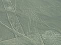
The Nazca Lines are huge, ancient drawings on the ground in the Nazca Desert in southern Peru. These amazing figures are called geoglyphs. Some of the biggest drawings are as long as 370 meters (1,200 feet)!
In 1994, the UNESCO organization named the Nazca Lines a World Heritage Site. This means they are very important and need to be protected. The dry, flat land where the lines are found stretches for over 80 kilometers (50 miles). It's located between the towns of Nazca and Palpa, about 400 kilometers (250 miles) south of Lima.
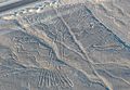
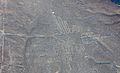
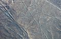
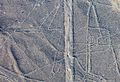
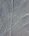
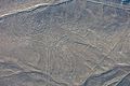
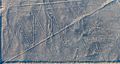
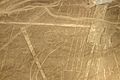
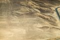
Experts believe the Nazca culture created these lines between 500 BC and 500 AD. The drawings are very different from each other. Some are simple lines and geometric shapes. More than 70 show animals like birds, fish, llamas, jaguars, and monkeys. There are also human figures and plant shapes, such as trees and flowers.
The Nazca people made these designs by removing reddish pebbles from the ground. This showed the lighter, whitish-gray soil underneath. This created a strong color difference. Scholars have different ideas about why the Nazca people made these drawings. But most agree they had a special religious meaning.
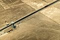
The lines have stayed preserved for a long time because the desert is very dry and doesn't have much wind. However, in recent years, some people moving into the area have caused damage to the lines.
Many people think you can only see the lines from an airplane. But you can also see them from nearby hills and other high places.
Contents
Discovering the Nazca Lines
The Nazca Lines were first mentioned in a book in 1553 by Pedro Cieza de León. He thought they were just trail markers. Even though you could see parts of them from nearby hills, Peruvian pilots were the first to really notice them. In 1927, an archaeologist named Toribio Mejía Xesspe saw them while hiking. He talked about them at a meeting in 1939.
Paul Kosok, a historian from Long Island University, was the first person to study the Nazca Lines seriously. In 1940–41, he was in Peru studying old irrigation systems. He flew over the lines and realized one looked like a bird. He also noticed how some lines pointed to where the sun rose during the winter. He started to wonder how they were made and why.
Later, Maria Reiche, a German mathematician and archaeologist, joined him. They thought the lines might have been like a calendar. They believed the lines pointed to where the sun and other stars appeared or disappeared on the horizon. Many experts, including archaeologists, historians, and mathematicians, have tried to figure out the lines' true purpose.
How the Lines Were Made
It's been easier to figure out how the lines were made than why. Experts think the Nazca people used simple tools to create them. They found wooden stakes in the ground at the end of some lines. These stakes support the idea that the Nazca people used them for measuring. One stake was tested to find its age, which helped date the lines.
A skeptic named Joe Nickell has even recreated the figures using only tools and methods that the Nazca people would have had. Scientific American magazine said his work was "remarkable" because it was so accurate. This shows that a small team could have made even the largest figures in just a few days, without needing to fly in the air.
Most lines are shallow trenches, about 10 to 15 centimeters (4 to 6 inches) deep. The Nazca people made these trenches by removing the reddish-brown pebbles from the desert surface. This showed the lighter clay earth underneath, creating a clear contrast. The clay layer has a lot of lime. When morning mist touches it, the lime hardens. This creates a protective layer that stops the wind from eroding the lines.
The Nazca people made hundreds of these large animal and human figures. The entire area covered by the lines is huge, nearly 450 square kilometers (170 square miles). Some figures are very big:
- The hummingbird is 93 meters (310 feet) long.
- The condor is 134 meters (440 feet) long.
- The monkey is 93 meters (310 feet) long and 58 meters (190 feet) wide.
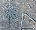
- The spider is 47 meters (150 feet) long.
The Nazca region is one of the driest places on Earth. It stays around 25°C (77°F) all year. This dry, windless weather has helped keep the lines safe and visible for centuries.
In 2011, a Japanese team found two new small figures. One looks like a human head and is very old. The other is an animal. In 2012, the team announced they would open a research center to study the area for 15 more years. They have found about 100 new geoglyphs since 2006.
Why Were They Made?

Experts like archaeologists and anthropologists have studied the ancient Nazca culture to understand the lines' purpose.
One idea is that the Nazca people made them to be seen by their gods in the sky. As mentioned, Paul Kosok and Maria Reiche thought the lines were like an observatory. They believed the lines pointed to where the sun and other celestial bodies rose or set during special times of the year. Many ancient cultures built earthworks that combined sky-watching with their religious beliefs, like Stonehenge in England. However, some experts like Gerald Hawkins and Anthony Aveni later said there wasn't enough proof for this idea.
Maria Reiche also thought some figures might represent constellations (groups of stars). Another astronomer, Phyllis B. Pitluga, suggested the animal figures were "heavenly shapes." She believed they were not constellations themselves, but dark patches within the Milky Way galaxy.
In 1985, archaeologist Johan Reinhard suggested a different idea. He found that the Nazca people worshipped mountains and water sources. He thought the lines and figures were part of religious practices to ask for water. Water was very important for their crops. He believed the lines were sacred paths to places where they worshipped these gods. The animal figures were symbols to ask the gods for help with water. The exact meanings of many figures are still a mystery.
Another theory, from art historian Henri Stierlin, suggested the lines might have been giant looms. He thought the Nazca people used them to make very long pieces of fabric, similar to textiles found on ancient mummies. This idea is not widely accepted, but scholars do notice similarities between the patterns on the textiles and the Nazca Lines.
Other Ideas About the Lines

Some other theories about the Nazca Lines include:
- The geometric lines might show where water flowed or were part of irrigation plans.
- The spider, bird, and plant figures could be symbols of fertility, meaning they wished for good crops and many offspring.
- The lines might have worked as an astronomical calendar.
Phyllis Pitluga, the astronomer, also suggested that the giant spider figure might be a special diagram of the constellation Orion. She thought three straight lines leading to the spider were used to track the stars in Orion's Belt. However, other experts noted she didn't explain all the other lines in the figure.
Jim Woodmann had a very different idea. He thought the Nazca Lines could only have been made if the Nazca people could fly to see the figures from above. He suggested they might have used hot-air balloons. To test this, Woodmann built a hot-air balloon using materials and methods he thought the Nazca people might have had. The balloon did fly! However, most scholars don't agree with Woodmann's idea because there's no other proof that the Nazca people had balloons.
Protecting the Lines
People who work to preserve the Nazca Lines are worried about pollution and erosion. These problems are often caused by deforestation (cutting down trees) in the region. Protecting these ancient wonders is very important for future generations.
Images for kids
-
The Spider
-
The Tree
-
The Hummingbird
-
The Condor
-
The Whale
-
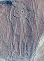
The Giant
-

The Pelican
-
The Dog
-
The Monkey
-
The Heron
-

Phytomorphic glyphs
-

Hands
-
The Parrot
-
The Lizard
-
The Spiral
-
The Flower


See also
 In Spanish: Líneas de Nazca para niños
