
Iron Mountains (California) facts for kids
Quick facts for kids Iron Mountains (California) |
|
|---|---|
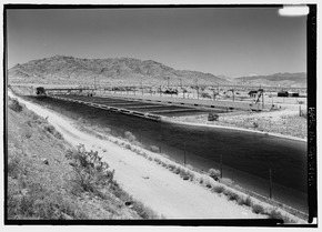
Canal connecting to the Iron Mountain Pump Plant at the southeast foothills region of the Iron Mountains (California).
(view due west) |
|
| Highest point | |
| Elevation | 2,182 feet (665 m) |
| Dimensions | |
| Length | 12.5 mi (20.1 km) NNW-SSE |
| Width | 7.5 mi (12.1 km) E-W |
| Geography | |

Location in California
|
|
| Country | United States |
| State | California |
| District | San Bernardino County |
| Range coordinates | 34°10′16″N 115°12′34″W / 34.17111°N 115.20944°W |
| Topo map | USGS Iron Mountains |
The Iron Mountains are a group of mountains in eastern California. They are mostly in San Bernardino County. A small part of the mountains also reaches into Riverside County to the south.
Where Are the Iron Mountains?
These mountains are surrounded by other interesting places. To the east, you'll find Ward Valley and the Turtle Mountains. The Old Woman Mountains are located to the north.
If you look to the west, across Cadiz Valley, you'll see the Calumet Mountains. To the southwest are the Coxcomb Mountains, which are part of Joshua Tree National Park. South of the Iron Mountains, past Granite Pass, are the Granite Mountains.
Water and Tunnels
An important water system, the Colorado River Aqueduct, passes through these mountains. This aqueduct carries water from the Colorado River to Southern California. It goes right through the Iron Mountains using a special path called the Iron Mountain Tunnel.
Next to the mountains, on the east side, is the Iron Mountain Pump Plant. This plant helps move water through the aqueduct system.
World War II Training Camp
During World War II, from 1942 to 1944, a special place called Camp Iron Mountain was built near these mountains. The United States Army used this camp to train soldiers. They were preparing to fight in North Africa against the Nazis.
Famous General George S. Patton and his 2nd Armored Division were stationed at Camp Iron Mountain. The airstrip at the Iron Mountain Pump Plant was once part of this important training camp.
