Vidal Valley facts for kids
Quick facts for kids Vidal Valley |
|
|---|---|

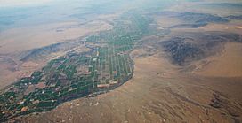
This picture shows the Parker Valley from above, looking south. You can see the end of Vidal Valley on the bottom right, where it meets the Colorado River area. The Riverside Mountains are in the middle right, and the Big Maria Mountains are further away on the right. Across the river in Arizona, you can spot the Mesquite Mountains.
|
|
| Length | 20 miles (32 km) |
| Width | 10 miles (16 km) |
| Geography | |
| Location | San Bernardino County, CA & Riverside County, CA |
| Population centers | Vidal Junction, Vidal, Rig River |
| Rivers | Vidal Wash & Colorado River |
Vidal Valley is a long valley, about 20 miles (32 km) in length. It is located in the very eastern part of the Colorado Desert. This valley is right next to the famous Colorado River. Most of Vidal Valley is in eastern San Bernardino County, California. However, the part where its water flows out into the Colorado River is in northeast Riverside County.
Vidal Valley forms a large border along the south side of the Whipple Mountains. These mountains are a big landform that makes the Colorado River flow in a special way. The valley's southeast end connects to Parker Valley near the Colorado River. This area is also close to the northern part of the Riverside Mountains. A large water channel called the Colorado River Aqueduct crosses the middle of the valley at a place called Vidal Junction, California. Vidal Valley is also located directly east of the dry lake bed known as Danby Dry Lake.
Contents
Exploring Vidal Valley's Geography
Vidal Valley has some interesting natural borders. The Whipple Mountains are to its northeast. To the south, you'll find the Riverside Mountains. The valley's water generally flows from the northwest towards the southeast. This water then empties into a section of the Colorado River that flows southwest.
Mountains and Borders
On the western side of the northern part of Vidal Valley are the Turtle Mountains. This area is also near the southern side of the Chemehuevi Valley. The very center of Vidal Valley, both east-west and north-south, is at Vidal Junction. This important spot is where U.S. Route 95 in California and California State Route 62 meet. Vidal Junction is located at 34°11′20″N 114°34′26″W / 34.18889°N 114.57389°W.
Nature and Climate
Vidal Valley is a special place for nature. It's a "transition zone" for climate, ecosystems, and plant life. This means it's where the lower, warmer Colorado Desert in the south meets the higher, cooler Mojave Desert to the north. You can see different types of plants and animals here because of this mix of desert environments.
How Water Flows: Watersheds
The water from Vidal Valley flows into the Colorado River. This area is part of a "watershed," which is like a big bowl where all the rain and water collect and drain into a common river or lake. On the opposite side of the Colorado River in western Arizona, there's another watershed called the Bouse Wash Watershed. Both of these watersheds empty into the Parker Valley. Much of Parker Valley is part of the Colorado River Indian Reservation.
Desert "washes" are like dry riverbeds. Usually, very little or no water flows in them where they meet the Colorado River. Water only flows strongly during big rainstorm events. Both Vidal Valley and the Bouse Wash areas are part of the northern section of the Imperial Reservoir Watershed.
The highest part of the valley, where the water starts to collect, is north of Vidal Junction. The "water divide" – the highest point that separates different watersheds – is east of the Turtle Mountains. It's also directly west of the Whipple Mountains. North of this water divide, you'll find the southern part of Chemehuevi Valley and Chemehuevi Wash.
 | William Lucy |
 | Charles Hayes |
 | Cleveland Robinson |


