Ash Fork, Arizona facts for kids
Quick facts for kids
Ash Fork, Arizona
|
|
|---|---|

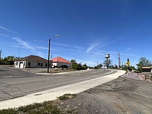
Route 66 in Ash Fork
|
|

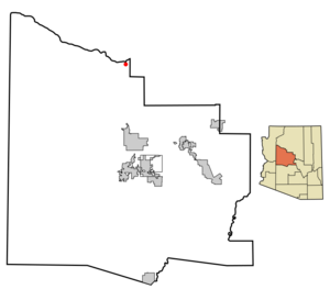
Location in Yavapai County and the state of Arizona
|
|
| Country | United States |
| State | Arizona |
| County | Yavapai |
| Area | |
| • Total | 2.31 sq mi (5.98 km2) |
| • Land | 2.31 sq mi (5.98 km2) |
| • Water | 0.00 sq mi (0.00 km2) |
| Elevation | 5,181 ft (1,579 m) |
| Population
(2020)
|
|
| • Total | 361 |
| • Density | 156.48/sq mi (60.41/km2) |
| Time zone | UTC-7 (MST) |
| ZIP code |
86320
|
| Area code(s) | 928 |
| FIPS code | 04-04440 |
| GNIS feature ID | 2407771 |
Ash Fork is a small community in Yavapai County, Arizona, United States. It is known as a census-designated place, which means it's a specific area identified by the census bureau. In 2020, about 361 people lived there. Ash Fork is famous for its stone quarries and its connection to the historic Route 66.
Contents
History of Ash Fork
Ash Fork proudly calls itself "The Flagstone Capital of the World." This is because many stone quarries and stone yards are found in and around the town. Flagstone is a type of flat stone often used for patios and paths. The town officially received this special title in 2014 from the Arizona House of Representatives.
The community started in October 1882 as a stop for the Santa Fe Railroad. A railroad official named F.W. Smith supposedly named it in 1883. He saw a thick group of ash trees at the site. The first official post office opened on April 12, 1883.
After a big fire in 1885, the entire town of Ash Fork burned down again in 1893. It was then rebuilt on the other side of the railroad tracks. That is where the town stands today.
Ash Fork's Famous Connections
Later, Ash Fork was home to a large hotel called the Escalante. This hotel was part of the "Harvey House" chain, run by the Fred Harvey Company. These hotels were known for their good service and food. The Escalante was built in 1907 and closed in 1948.
Ash Fork's location along the railway and later on famous U.S. Route 66 made it well-known. Many travelers crossing the country recognized it. The town was even mentioned briefly in old movies like 1947's Dark Passage.
Route 66 brought a small boost to the town's economy in the 1950s. However, building the divided highway through town destroyed many shops and sidewalks. This changed the look of the downtown area forever. When the Santa Fe Railroad moved its main line away from the town in 1960, Ash Fork lost many people. Most families who worked for the railway had to leave.
Fires and Changes
Another large fire, known as the "Big Fire," hit the community on November 20, 1977. It destroyed most of the businesses downtown. Soon after, I-40 was built, bypassing the town. This greatly reduced traffic on Route 66, and the local economy never fully recovered.
The community's last major fire happened on October 7, 1987. It destroyed almost all the remaining buildings along the main business street.
Today, part of what was Route 66 still runs through Ash Fork. It is now a divided highway. Park Avenue runs east, and Lewis Avenue runs west. Both serve as main roads. You can still see historic buildings along these streets. These include old railroad company houses. Most of the town's shops are on Park Avenue. The Ash Fork Post Office is also on this street.
Some areas of Ash Fork were used to film the 1992 movie Universal Soldier. This was supposedly because some old buildings, like a motel, were very cheap and in poor condition. They were even blown up for the movie's special effects!
Geography of Ash Fork
Ash Fork is located in an area of about 2.3 square miles (5.98 square kilometers). All of this area is land.
Natural Attractions
There are some interesting geological places nearby. The Cathedral Caves are about 10 miles (16 km) west of town. Another spot is Dante's Descent, also called "Devil's Hole." This is a 275-foot (84 m) deep sinkhole. It is about 5 miles (8 km) northwest of Ash Fork. However, Dante's Descent is now closed to the public by the state. You can find pictures and history about it at the Ash Fork Library.
Ash Fork is close to Kaibab National Forest and Coconino National Forest. Famous places like the Grand Canyon are also about an hour's drive away on major roads.
Historic Roads
About 15 miles (24 km) north of Ash Fork is Beale Road. This road is special because it was the first highway funded by the U.S. government. The world-famous U.S. Route 66 also runs directly through the town.
The longest original part of Route 66 still existing is about 9.6 miles (15.4 km) long. You can find it between Ash Fork and Seligman, Arizona. It starts just past Ash Fork at Crookton Road. The area around Ash Fork and its towns even helped inspire the 2006 Pixar movie Cars!
Climate
Ash Fork has warm, dry summers. The average monthly temperatures do not go above 89 °F (31.7 °C). This type of weather is called a warm-summer Mediterranean climate.
Population of Ash Fork
| Historical population | |||
|---|---|---|---|
| Census | Pop. | %± | |
| 1910 | 517 | — | |
| 1920 | 571 | 10.4% | |
| 1930 | 894 | 56.6% | |
| 1960 | 681 | — | |
| 2000 | 457 | — | |
| 2010 | 396 | −13.3% | |
| 2020 | 361 | −8.8% | |
| U.S. Decennial Census | |||
Ash Fork first appeared on the U.S. Census in 1910. Back then, it was a small village with 517 residents. It was the fourth-largest community in Yavapai County. In 2000, it became a census-designated place (CDP).
In 2000, there were 457 people living in Ash Fork. There were 149 households and 109 families. The average household had about three people. The median age was 34 years old.
The many flagstone quarries and companies are often the biggest employers in the area. The local school district also employs many people. Most teachers travel from nearby cities to work there.
Education
Ash Fork is part of the Ash Fork School District.
Notable people
- Adam Kokesh, a political activist who supports libertarian ideas.
See also
 In Spanish: Ash Fork (Arizona) para niños
 | Jackie Robinson |
 | Jack Johnson |
 | Althea Gibson |
 | Arthur Ashe |
 | Muhammad Ali |


