
Wickenburg, Arizona facts for kids
Quick facts for kids
Wickenburg, Arizona
|
|||
|---|---|---|---|

Frontier Street
|
|||
|
|||

Location in Maricopa and Yavapai counties, Arizona
|
|||
| Country | United States | ||
| State | Arizona | ||
| Counties | Maricopa, Yavapai | ||
| Founded | 1863 | ||
| Incorporated | 1909 | ||
| Area | |||
| • Total | 26.52 sq mi (68.68 km2) | ||
| • Land | 26.51 sq mi (68.67 km2) | ||
| • Water | 0.01 sq mi (0.01 km2) | ||
| Elevation | 2,202 ft (671 m) | ||
| Population
(2020)
|
|||
| • Total | 7,474 | ||
| • Estimate
(2022)
|
7,920 | ||
| • Density | 299/sq mi (115.3/km2) | ||
| Time zone | UTC−7 (Mountain (MST) (no DST)) | ||
| ZIP Codes |
85358, 85390
|
||
| Area code(s) | 928 | ||
| FIPS code | 04-82740 | ||
| GNIS feature ID | 2413484 | ||
| Sales tax | 8.5% | ||
.svg)

Wickenburg is a town in Arizona, United States. It is located in both Maricopa and Yavapai counties. In 2020, about 7,474 people lived there. By 2022, the population was estimated to be around 7,920.
Contents
Wickenburg's Story: A Look Back in Time
.jpg)

The land where Wickenburg now stands became part of the United States in 1848. This happened after the Mexican–American War ended with the Treaty of Guadalupe Hidalgo. Early explorers, called Gila Rangers, surveyed the area. They were looking for Native groups who had attacked mail routes and miners.
Gold Rush and Town Founding
In 1862, gold was found near Yuma on the Colorado River. This discovery brought many American prospectors to central Arizona. Many places are now named after these early pioneers. For example, the Weaver Mountains are named after Pauline Weaver.
A German prospector named Henry Wickenburg made a big discovery in 1863. He found the Vulture Mine, which produced over $30 million worth of gold. This was a huge amount of money back then!
Soon, ranchers and farmers settled along the Hassayampa River. They joined the miners to create the town of Wickenburg in 1863. Wickenburg became an important place. It supplied goods to mines and army posts in the Arizona Territory.
Challenges and Growth
As Wickenburg grew, there were conflicts with the Yavapai people. Federal troops left the area during the American Civil War (1861-1865). This left settlements unprotected.
Conflicts continued for several years. By 1869, many people from both sides had been killed. After the war, Union troops and local volunteers moved the Yavapai to a reservation.
Even after this, some Yavapai groups continued to raid stagecoaches and farms. This caused a lot of tension in the area. In 1871, a serious attack happened in Wickenburg. Many people had to leave the town.
In 1872, General George Crook led a campaign to bring peace. After several months, the Yavapai groups were defeated in the Battle of Salt River Canyon. This battle helped end the major conflicts.
A new treaty was made. The Yavapai reservation was moved to a different area. They had to give up their weapons and live under American administration. After two years, they were moved again to the San Carlos Apache Indian Reservation.
Modern Wickenburg: From Ranches to Resorts
Wickenburg faced many challenges in its early years. These included conflicts, outlaws, and a big flood in 1890. This flood killed nearly 70 residents.
However, the town kept growing. The arrival of the railroad in 1895 helped it become successful. Today, the old train depot is home to the Wickenburg Chamber of Commerce.
Tourism also became very important. In the 1950s and 1960s, Wickenburg was known as the "Dude Ranch Capital of the World." There were as many as 14 guest ranches. Today, some of these ranches are still open. One, Rancho de los Caballeros, is now a golf resort. Another, Remuda Ranch, is a treatment center and the town's largest employer.
During World War II, Wickenburg helped the war effort. The Army trained thousands of glider pilots at a new airfield near the town.
Wickenburg's Location and Weather
Wickenburg is in the northwest part of Maricopa County. A small part of the town extends into Yavapai County.
How to Get There
- Phoenix is about 53 miles (85 km) to the southeast using U.S. Route 60.
- Blythe, California, is about 114 miles (183 km) to the west-southwest.
- U.S. Route 93 starts in Wickenburg and goes northwest to Kingman, which is 129 miles (208 km) away.
Land and Water
The town covers about 26.52 square miles (68.68 km2). Most of this is land. The Hassayampa River flows through the east side of town. It doesn't always have water in it.
Climate in Wickenburg
Wickenburg has a semi-arid climate. This means it's dry, but not as hot as some desert areas like Phoenix. Summers can still be very hot.
| Climate data for Wickenburg, Arizona (1981–2010) | |||||||||||||
|---|---|---|---|---|---|---|---|---|---|---|---|---|---|
| Month | Jan | Feb | Mar | Apr | May | Jun | Jul | Aug | Sep | Oct | Nov | Dec | Year |
| Record high °F (°C) | 88 (31) |
89 (32) |
97 (36) |
102 (39) |
114 (46) |
118 (48) |
121 (49) |
117 (47) |
116 (47) |
109 (43) |
95 (35) |
87 (31) |
121 (49) |
| Mean daily maximum °F (°C) | 64.5 (18.1) |
67.9 (19.9) |
73.3 (22.9) |
81.5 (27.5) |
90.6 (32.6) |
100.2 (37.9) |
103.6 (39.8) |
101.1 (38.4) |
96.2 (35.7) |
85.7 (29.8) |
73.7 (23.2) |
65.4 (18.6) |
83.6 (28.7) |
| Mean daily minimum °F (°C) | 31.2 (−0.4) |
34.3 (1.3) |
38.4 (3.6) |
43.4 (6.3) |
50.4 (10.2) |
58.7 (14.8) |
69.6 (20.9) |
68.7 (20.4) |
60.5 (15.8) |
48.5 (9.2) |
37.7 (3.2) |
31.5 (−0.3) |
47.7 (8.8) |
| Record low °F (°C) | 10 (−12) |
14 (−10) |
19 (−7) |
24 (−4) |
32 (0) |
38 (3) |
48 (9) |
47 (8) |
37 (3) |
23 (−5) |
16 (−9) |
10 (−12) |
10 (−12) |
| Average precipitation inches (mm) | 1.32 (34) |
1.54 (39) |
1.22 (31) |
.41 (10) |
.21 (5.3) |
.11 (2.8) |
1.39 (35) |
2.11 (54) |
1.22 (31) |
.64 (16) |
.90 (23) |
1.08 (27) |
12.15 (308.1) |
| Average snowfall inches (cm) | 0 (0) |
0.1 (0.25) |
0 (0) |
0 (0) |
0 (0) |
0 (0) |
0 (0) |
0 (0) |
0 (0) |
0 (0) |
0 (0) |
0.1 (0.25) |
0.2 (0.51) |
People of Wickenburg
| Historical population | |||
|---|---|---|---|
| Census | Pop. | %± | |
| 1870 | 174 | — | |
| 1880 | 104 | −40.2% | |
| 1910 | 570 | — | |
| 1920 | 527 | −7.5% | |
| 1930 | 734 | 39.3% | |
| 1940 | 995 | 35.6% | |
| 1950 | 1,736 | 74.5% | |
| 1960 | 2,445 | 40.8% | |
| 1970 | 2,698 | 10.3% | |
| 1980 | 3,535 | 31.0% | |
| 1990 | 4,515 | 27.7% | |
| 2000 | 5,082 | 12.6% | |
| 2010 | 6,363 | 25.2% | |
| 2020 | 7,474 | 17.5% | |
| 2022 (est.) | 7,920 | 24.5% | |
| U.S. Decennial Census 2020 Census |
|||
In 2020, the census showed that 7,474 people lived in Wickenburg. There were 3,634 households and 2,210 families.
Fun Facts and Local Lore
- In the late 1800s, there were many questionable mining stories around Wickenburg. A joke started that anyone who drank from the Hassayampa River could no longer tell the truth! So, a "Hassayamper" became a name for someone who tells tall tales.
Historic Places to See
There are many buildings and sites in Wickenburg that are considered historic. You can find them listed in the National Register of Historic Places.
- Further information: List of historic properties in Wickenburg, Arizona
Getting Around Wickenburg
The town has its own airport, Wickenburg Municipal Airport. It's for general aviation, meaning it doesn't have big commercial airlines.
Images for kids
-
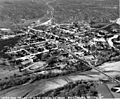
Wickenburg in the 1940s
-
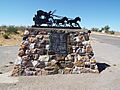
A marker near where a historical conflict took place in 1871.
-
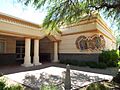
Wickenburg Town Hall at 155 North Tegner Street.
-
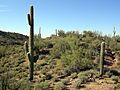
The beautiful Sonoran Desert outside Wickenburg, Arizona.


See also
 In Spanish: Wickenburg (Arizona) para niños
