
Mayer, Arizona facts for kids
Quick facts for kids
Mayer, Arizona
|
|
|---|---|
|
CDP
|
|
-Mayer_welcome_sign.jpg)
"Welcome to Mayer, Arizona"
|
|

Location in Yavapai County and the state of Arizona
|
|

Mayer, Arizona
Location in the United States
|
|
| Country | United States |
| State | Arizona |
| County | Yavapai |
| Area | |
| • Total | 20.15 sq mi (52.19 km2) |
| • Land | 20.15 sq mi (52.19 km2) |
| • Water | 0.00 sq mi (0.00 km2) |
| Elevation | 4,415 ft (1,346 m) |
| Population
(2020)
|
|
| • Total | 1,558 |
| • Density | 77.31/sq mi (29.85/km2) |
| Time zone | UTC-7 (MST) |
| ZIP code |
86333
|
| Area code(s) | 928 |
| FIPS code | 04-45180 |
| GNIS feature ID | 31605 |
Mayer is a small community in Yavapai County, Arizona, in the United States. It is called a "census-designated place" (CDP) because it is a recognized community. However, it does not have its own local government like a city or town. In 2020, about 1,558 people lived there. Mayer is special because it has three places listed on the National Register of Historic Places. These include the Mayer Apartments, the Mayer Business Block, and the Mayer Red Brick Schoolhouse.
Contents
History of Mayer
The area where Mayer is located was originally known as Wi:kidoʼyoʼ by the Yavapai people. A local story says that the name "Mayer" came from a boy named Mayer who ran away and ended up in the area.
During World War II, from May to June 1942, a temporary camp was set up here. It was called the Mayer Assembly Center. About 245 Japanese Americans were held there for a short time. These families were mostly from the Salt River Valley area in Maricopa County. They lived in military-style barracks for less than a month. After that, they were moved to a more permanent camp called Poston, Arizona.
The 2017 Goodwin Wildfire
A large wildfire, known as the Goodwin Fire, started on June 24, 2017. It began in the Bradshaw Mountains near Mayer. Days later, this fire caused more than 9,000 residents to leave their homes for safety. The wildfire burned a large area of land, about 28,516 acres. Highway 69 was closed between Mayer and Dewey-Humboldt. The fire destroyed about five buildings and one firefighter was injured.
Geography and Climate
Mayer is located at 34°25′9″N 112°14′59″W / 34.41917°N 112.24972°W. This means it is in a specific spot on the map.
According to the United States Census Bureau, the total area of Mayer is about 20.1 square miles (52.1 square kilometers). All of this area is land.
Mayer's Climate
Mayer has a semi-arid climate. This means it is generally dry, but not as dry as a desert. It gets some rain, but not a lot. On climate maps, this type of climate is often called "BSk."
Population Information
| Historical population | |||
|---|---|---|---|
| Census | Pop. | %± | |
| 2000 | 1,408 | — | |
| 2010 | 1,497 | 6.3% | |
| 2020 | 1,558 | 4.1% | |
| U.S. Decennial Census | |||

In 2000, there were 1,408 people living in Mayer. There were 585 households and 379 families. The population density was about 70.2 people per square mile (27.1 people per square kilometer).
About 24% of the people were under 18 years old. About 19% were 65 years or older. The average age of people in Mayer was 44 years. For every 100 females, there were about 99 males.
Education in Mayer
Most of Mayer is part of the Mayer Unified School District. A smaller part is in the Humboldt Unified School District. The Mayer Unified School District runs Mayer High School, which is located in Spring Valley.
There is also a private school nearby called The Orme School. Even though it has a Mayer, Arizona postal address, it is not actually inside the Mayer census-designated place. However, The Arizona Republic newspaper describes the school as being in Mayer.
The Mayer Library is operated by the Yavapai County Free Library District.
Historic Places in Mayer
Several important buildings in Mayer are listed on the National Register of Historic Places. This means they are recognized for their historical importance.

-
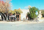
Historic Mayer Business Block.
-
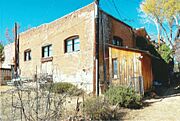
Rear view of the Mayer General Market Store.
-
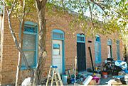
Mayer Apartment #1.
-
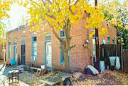
Mayer Apartment #2.
-
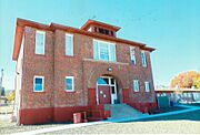
Mayer Red Brick Schoolhouse.
-Historic_Mayer_Business_Block-1902.jpg)


See also
 In Spanish: Mayer (Arizona) para niños
