
Borah Peak facts for kids
Quick facts for kids Borah Peak |
|
|---|---|

Mount Borah, August 2009
|
|
| Highest point | |
| Elevation | 12,662 ft (3,859 m) |
| Prominence | 5,982 ft (1,823 m) |
| Listing |
|
| Geography | |

Borah Peak
Location in Idaho
|
|
| Location | Custer County, Idaho, U.S. |
| Parent range | Lost River Range |
| Topo map | USGS Borah Peak |
| Climbing | |
| First ascent | 1912 by T.M. Bannon |
| Easiest route | Class 3 Scramble |
Borah Peak, also known as Mount Borah or Beauty Peak, is the tallest mountain in the U.S. state of Idaho. It is also one of the most noticeable peaks in the main part of the United States. You can find it in the middle of the Lost River Range, inside the Challis National Forest in eastern Custer County.
What is Borah Peak?

For a long time, this mountain didn't have a name. People thought another mountain, Hyndman Peak, was the tallest in Idaho. But then, they discovered Borah Peak was actually higher!
In February 1934, the U.S. Geological Survey decided to name it. They chose to honor William Borah, a very important U.S. Senator from Idaho. He had served in the Senate for almost 27 years. He was known as the "Lion of Idaho" because he was a strong speaker. He believed the U.S. should mostly stay out of other countries' problems.
The 1983 Earthquake
On Friday, October 28, 1983, a big earthquake happened near Borah Peak. It struck at 8:06 in the morning. This earthquake measured 6.9 on the moment magnitude scale, which is a way to measure how strong an earthquake is.
During the earthquake, Mount Borah actually rose about 1 foot (30 cm). The valley next to it, called the Lost River Valley, dropped about 8 feet (2.4 m). The side of the peak was scarred, and you can still see the mark today. Sadly, two children in Challis lost their lives. They were hit by falling bricks while walking to elementary school.
Climbing Borah Peak
Climbing Borah Peak is a challenging adventure. The most common way to reach the top is called the "normal route." This path goes up over 5,262 feet (1,604 m) from the start of the trail. It's a very tough hike for most of the way.
Near the top, climbers reach a tricky part called Chickenout Ridge. This is a narrow, rocky section. Many people decide to turn back here because it looks dangerous. In colder months, this ridge often has snow. Climbers usually need an ice axe and know how to use it safely.
For very experienced climbers, the north face of Borah Peak offers an even bigger challenge. It has snow and ice all year round. Sadly, three climbers have died on Borah Peak over the years.
Images for kids
-
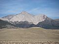
Mount Borah, August 2009
