Challis, Idaho facts for kids
Quick facts for kids
Challis, Idaho
|
|
|---|---|

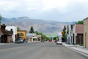
Main Street in Challis, May 2007
|
|

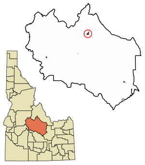
Location of Challis in Custer County, Idaho.
|
|
| Country | United States |
| State | Idaho |
| County | Custer |
| Area | |
| • Total | 1.94 sq mi (5.04 km2) |
| • Land | 1.92 sq mi (4.97 km2) |
| • Water | 0.03 sq mi (0.07 km2) |
| Elevation | 5,214 ft (1,589 m) |
| Population
(2020)
|
|
| • Total | 897 |
| • Estimate
(2023)
|
924 |
| • Density | 568.53/sq mi (219.47/km2) |
| Time zone | UTC-7 (Mountain (MST)) |
| • Summer (DST) | UTC-6 (MDT) |
| ZIP code |
83226
|
| Area code(s) | 208 |
| FIPS code | 16-13780 |
| GNIS feature ID | 2409432 |
Challis is the biggest city in Custer County, Idaho, in the United States. It is the main town where the county government is located, also known as the county seat. In 2020, about 902 people lived there. By 2023, the population grew a little to 924.
Contents
History of Challis
Challis was started in 1878. It was named after A.P. Challis, who helped plan the town's layout. The Challis post office also opened in 1878.
Some buildings in Challis are very old and important. They are listed on the National Register of Historic Places. This means they are protected because of their history. Examples include the I.O.O.F. Hall and Twin Peaks Sports.
Highways and Roads
Challis is connected by important roads:
 - US 93: This highway goes north to Salmon and south to Mackay.
 SH 75 - Idaho State Highway 75: This highway goes southwest to Stanley.
Part of the Salmon River Scenic Byway uses both of these highways. It's a beautiful route that stretches from Stanley to Salmon.
Earthquakes in Challis
Challis has experienced some strong earthquakes.
The 1983 Borah Peak Earthquake
On October 28, 1983, a big earthquake happened near Challis. It was called the Borah Peak earthquake. The earthquake was very strong, measuring 6.9 on the moment magnitude scale.
Many buildings in Challis and nearby Mackay were damaged. About 11 businesses and 39 homes had major damage. Another 200 houses had smaller damage. Sadly, two children in Challis lost their lives when a store front fell on them while they were walking to school.
The 2020 Central Idaho Earthquake
On March 31, 2020, another strong earthquake hit. It measured 6.5 on the moment magnitude scale. The center of this earthquake was about 45 miles (72 km) west of Challis. This was the second strongest earthquake ever recorded in Idaho.
Geography and Climate
Challis covers an area of about 1.88 square miles (4.87 square kilometers). Most of this area is land, with a small part being water.
The climate in Challis is called a semi-arid climate. This means it has cold winters and hot summers. It doesn't get a lot of rain or snow throughout the year.
| Climate data for Challis, Idaho (Challis Airport), 1991–2020 normals, extremes 1895–present | |||||||||||||
|---|---|---|---|---|---|---|---|---|---|---|---|---|---|
| Month | Jan | Feb | Mar | Apr | May | Jun | Jul | Aug | Sep | Oct | Nov | Dec | Year |
| Record high °F (°C) | 60 (16) |
65 (18) |
74 (23) |
87 (31) |
96 (36) |
100 (38) |
103 (39) |
103 (39) |
99 (37) |
89 (32) |
75 (24) |
63 (17) |
103 (39) |
| Mean maximum °F (°C) | 45.0 (7.2) |
50.9 (10.5) |
64.7 (18.2) |
74.1 (23.4) |
83.9 (28.8) |
92.3 (33.5) |
97.6 (36.4) |
95.3 (35.2) |
88.7 (31.5) |
77.0 (25.0) |
59.5 (15.3) |
46.9 (8.3) |
97.2 (36.2) |
| Mean daily maximum °F (°C) | 29.2 (−1.6) |
36.7 (2.6) |
49.2 (9.6) |
56.8 (13.8) |
66.8 (19.3) |
75.5 (24.2) |
86.9 (30.5) |
84.9 (29.4) |
74.5 (23.6) |
58.5 (14.7) |
40.5 (4.7) |
28.8 (−1.8) |
57.4 (14.1) |
| Daily mean °F (°C) | 20.0 (−6.7) |
26.8 (−2.9) |
37.3 (2.9) |
44.0 (6.7) |
53.4 (11.9) |
60.9 (16.1) |
69.3 (20.7) |
67.4 (19.7) |
58.2 (14.6) |
45.0 (7.2) |
30.5 (−0.8) |
19.8 (−6.8) |
44.4 (6.9) |
| Mean daily minimum °F (°C) | 10.7 (−11.8) |
17.0 (−8.3) |
25.5 (−3.6) |
31.2 (−0.4) |
40.0 (4.4) |
46.3 (7.9) |
51.7 (10.9) |
49.9 (9.9) |
42.0 (5.6) |
31.6 (−0.2) |
20.6 (−6.3) |
10.8 (−11.8) |
31.4 (−0.3) |
| Mean minimum °F (°C) | −10.4 (−23.6) |
−2.5 (−19.2) |
10.0 (−12.2) |
18.2 (−7.7) |
25.8 (−3.4) |
33.6 (0.9) |
41.6 (5.3) |
39.4 (4.1) |
29.3 (−1.5) |
16.2 (−8.8) |
2.8 (−16.2) |
−8.3 (−22.4) |
−15.1 (−26.2) |
| Record low °F (°C) | −33 (−36) |
−31 (−35) |
−16 (−27) |
3 (−16) |
15 (−9) |
24 (−4) |
31 (−1) |
20 (−7) |
17 (−8) |
−4 (−20) |
−17 (−27) |
−34 (−37) |
−34 (−37) |
| Average precipitation inches (mm) | 0.41 (10) |
0.36 (9.1) |
0.46 (12) |
0.52 (13) |
0.93 (24) |
0.93 (24) |
0.42 (11) |
0.45 (11) |
0.85 (22) |
0.56 (14) |
0.52 (13) |
0.52 (13) |
6.93 (176.1) |
| Average snowfall inches (cm) | 4.6 (12) |
3.0 (7.6) |
2.3 (5.8) |
0.7 (1.8) |
0.1 (0.25) |
0.0 (0.0) |
0.0 (0.0) |
0.0 (0.0) |
0.0 (0.0) |
0.3 (0.76) |
2.5 (6.4) |
4.0 (10) |
17.5 (44.61) |
| Average precipitation days (≥ 0.01 in) | 6.4 | 5.4 | 6.8 | 6.8 | 8.9 | 7.6 | 4.6 | 5.3 | 4.6 | 5.2 | 6.4 | 7.1 | 75.1 |
| Average snowy days (≥ 0.1 in) | 3.3 | 2.2 | 1.5 | 0.4 | 0.1 | 0.0 | 0.0 | 0.0 | 0.0 | 0.2 | 1.8 | 3.1 | 12.6 |
| Source 1: NOAA | |||||||||||||
| Source 2: National Weather Service (average snowfall/snow days 1895–1996) | |||||||||||||
Who Lives in Challis?
| Historical population | |||
|---|---|---|---|
| Census | Pop. | %± | |
| 1880 | 614 | — | |
| 1890 | 356 | −42.0% | |
| 1910 | 338 | — | |
| 1920 | 484 | 43.2% | |
| 1930 | 418 | −13.6% | |
| 1940 | 620 | 48.3% | |
| 1950 | 728 | 17.4% | |
| 1960 | 732 | 0.5% | |
| 1970 | 784 | 7.1% | |
| 1980 | 758 | −3.3% | |
| 1990 | 1,073 | 41.6% | |
| 2000 | 909 | −15.3% | |
| 2010 | 1,081 | 18.9% | |
| 2020 | 902 | −16.6% | |
| U.S. Decennial Census | |||
In 2020, the census counted 897 people living in Challis. The city had 402 households and 234 families. Most people living there were White (91.9%). There were also smaller groups of Native American, Asian, and African American residents. About 6.2% of the population identified as Hispanic or Latino.
The average age in Challis in 2020 was 45.5 years old. About 20.4% of the people were under 18. Also, 19.8% were 65 years old or older. The number of males and females was almost equal, with slightly more females.
Famous People from Challis
- Lawrence Henry Chamberlain (1906–1989) was a well-known person from Challis. He became a dean at Columbia College and a vice president at Columbia University.
See also
 In Spanish: Challis (Idaho) para niños
 | James Van Der Zee |
 | Alma Thomas |
 | Ellis Wilson |
 | Margaret Taylor-Burroughs |


