
North Las Vegas, Nevada facts for kids
Quick facts for kids
North Las Vegas, Nevada
|
||
|---|---|---|

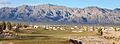
North Las Vegas and the surrounding Las Vegas Range
|
||
|
||
| Nicknames:
North Town
|
||
| Motto(s):
Your Community of Choice
|
||

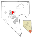
Location within Clark County
|
||

North Las Vegas, Nevada
Location in Nevada

North Las Vegas, Nevada
Location in the United States
|
||
| Country | ||
| State | ||
| County | Clark | |
| Founded | 1919 | |
| Incorporated | May 1, 1946 | |
| Government | ||
| • Type | Council–manager | |
| Area | ||
| • Total | 102.37 sq mi (265.13 km2) | |
| • Land | 102.32 sq mi (265.02 km2) | |
| • Water | 0.04 sq mi (0.11 km2) | |
| Elevation | 2,205 ft (672 m) | |
| Population
(2020)
|
||
| • Total | 262,527 | |
| • Density | 2,565.64/sq mi (990.60/km2) | |
| Time zone | UTC−8 (PST) | |
| • Summer (DST) | UTC−7 (PDT) | |
| ZIP codes |
89030–89033, 89036, 89081, 89084–89087
|
|
| Area code(s) | 702 and 725 | |
| FIPS code | 32-51800 | |
| GNIS feature ID | 0847435 | |

North Las Vegas is a busy city in Clark County, Nevada, USA. It's part of the larger Las Vegas Valley. In 2020, about 262,527 people lived here. By 2022, this number grew to an estimated 280,543.
The city officially became a city on May 1, 1946. It is the third largest city in Nevada by population. It is also the 75th most populated city in the entire United States.
Contents
History of North Las Vegas
Native Americans were the first people to live in this area. Paiute Indians settled here around 700 AD.
Early Settlements and Founding
In the 1860s, a man named Conrad Kiel started a ranch here. This was near where Carey Street and Losee Road are today. In 1917, Thomas L. Williams from Eureka, Utah visited the Las Vegas Valley. At that time, only Las Vegas, the Las Vegas Indian Colony, and Arden existed in the valley.
Williams liked the area because it had a lot of artesian water. This water comes from underground and flows to the surface. It was great for farming. In 1919, he moved his family to 160 acres of land. This land was about a mile from Las Vegas.
He started his own town by building a house and digging a well. He also made roads and set up a system of irrigation ditches. Williams wanted churches to be important in his new town. He encouraged them to buy land there.
"Old Town" and Growth
The town became known as "Old Town." In 1924, Williams built a second house. This house became the first business in town. It was called the Oasis Auto Court. It had a grocery store, a campground, a post office, and the town's only telephone.
Between 1928 and 1935, many workers from the Hoover Dam project moved to Williams' town. Las Vegas was not very welcoming to them. In 1932, the town created a board to help run things. The first school, Washington School, opened that same year.
Naming the City
The town needed a proper name. Williams did not want it named after himself. The town board voted between "North Las Vegas" and "Vegas Verdes." "Vegas Verdes" means "Green Meadows" in Spanish. "Vegas Verdes" won the first vote.
However, a board member named George Hansen wanted "North Las Vegas." He noticed that two members who voted for "Vegas Verdes" were absent at a later meeting. So, they voted again. This time, "North Las Vegas" won.
World War II and Incorporation
In 1939, Williams passed away. The town board then governed North Las Vegas. An elementary school and a road were later named after him.
During World War II, the Las Vegas Aerial Gunnery School opened in North Las Vegas. This school later became Nellis Air Force Base. On May 1, 1946, North Las Vegas officially became an incorporated city.
A Pilot's Sacrifice
On May 13, 1964, a student pilot named Raynor Lee Hebert took off from Nellis Air Force Base. He was flying an F-105 fighter jet. He had a problem with his plane and could not gain height.
Hebert realized that if he ejected, his plane would crash into Lincoln Elementary School. The school was full of 800 students. He bravely kept the plane steady. He flew it past the school before it crashed into some houses. Hebert and four people on the ground died. The city created Hebert Memorial Park with a plaque to honor his sacrifice.
Growth and Development
North Las Vegas grew a lot in the early 1960s. In the 1990s, the city added about 60 square miles (160 km2) of empty desert land. This was done to build more modern homes.
Geography and Climate

North Las Vegas is located in the Mojave Desert in the southwestern United States. It sits northeast of the city of Las Vegas. The city covers about 101.4 square miles (262.6 km2) of land. Only a tiny part, about 0.04 square miles (0.1 km2), is water. There are several large mountain ranges nearby in the Las Vegas Valley.
Weather in North Las Vegas
Because it's in the Mojave Desert, North Las Vegas has a desert climate. This means winters are usually mild, and summers are very hot. Snowfall is rare, happening only once every few years. Winter temperatures almost never drop below freezing. In the summer, strong thunderstorms, called monsoons, can bring heavy rain.
| Climate data for North Las Vegas, Nevada | |||||||||||||
|---|---|---|---|---|---|---|---|---|---|---|---|---|---|
| Month | Jan | Feb | Mar | Apr | May | Jun | Jul | Aug | Sep | Oct | Nov | Dec | Year |
| Record high °F (°C) | 80 (27) |
86 (30) |
93 (34) |
100 (38) |
112 (44) |
117 (47) |
119 (48) |
115 (46) |
116 (47) |
101 (38) |
88 (31) |
77 (25) |
119 (48) |
| Mean daily maximum °F (°C) | 58 (14) |
64 (18) |
71 (22) |
80 (27) |
89 (32) |
100 (38) |
105 (41) |
103 (39) |
95 (35) |
83 (28) |
68 (20) |
59 (15) |
81 (27) |
| Mean daily minimum °F (°C) | 30 (−1) |
35 (2) |
40 (4) |
47 (8) |
56 (13) |
64 (18) |
71 (22) |
69 (21) |
61 (16) |
49 (9) |
37 (3) |
30 (−1) |
49 (9) |
| Record low °F (°C) | 10 (−12) |
16 (−9) |
21 (−6) |
31 (−1) |
41 (5) |
48 (9) |
59 (15) |
54 (12) |
45 (7) |
25 (−4) |
17 (−8) |
11 (−12) |
10 (−12) |
| Average precipitation inches (mm) | 0.64 (16) |
0.68 (17) |
0.65 (17) |
0.21 (5.3) |
0.26 (6.6) |
0.08 (2.0) |
0.30 (7.6) |
0.49 (12) |
0.27 (6.9) |
0.29 (7.4) |
0.33 (8.4) |
0.38 (9.7) |
4.58 (116) |
Population and People
| Historical population | |||
|---|---|---|---|
| Census | Pop. | %± | |
| 1940 | 3,875 | — | |
| 1950 | 3,875 | 0.0% | |
| 1960 | 18,422 | 375.4% | |
| 1970 | 36,216 | 96.6% | |
| 1980 | 42,739 | 18.0% | |
| 1990 | 47,707 | 11.6% | |
| 2000 | 115,488 | 142.1% | |
| 2010 | 216,961 | 87.9% | |
| 2020 | 262,527 | 21.0% | |
| U.S. Decennial Census | |||
North Las Vegas has grown a lot over the years. Here's a look at the population changes and who lives there.
Population in 2020
In 2020, North Las Vegas had 262,527 people. The city is very diverse. About 40.73% of the people were Hispanic or Latino. Many different racial groups also live in North Las Vegas.
| Race / Ethnicity (NH = Non-Hispanic) | Pop 2000 | Pop 2010 | Pop 2020 | % 2000 | % 2010 | % 2020 |
|---|---|---|---|---|---|---|
| White alone (NH) | 42,880 | 67,687 | 64,187 | 37.13% | 31.20% | 24.45% |
| Black or African American alone (NH) | 21,528 | 41,561 | 56,049 | 18.64% | 19.16% | 21.35% |
| Native American or Alaska Native alone (NH) | 565 | 871 | 807 | 0.49% | 0.40% | 0.31% |
| Asian alone (NH) | 3,604 | 13,122 | 16,861 | 3.12% | 6.05% | 6.42% |
| Pacific Islander alone (NH) | 547 | 1,684 | 2,550 | 0.47% | 0.78% | 0.97% |
| Other race alone (NH) | 143 | 377 | 1,437 | 0.12% | 0.17% | 0.55% |
| Mixed race or Multiracial (NH) | 2,786 | 7,525 | 13,696 | 2.41% | 3.47% | 5.22% |
| Hispanic or Latino (any race) | 43,435 | 84,134 | 106,940 | 37.61% | 38.78% | 40.73% |
| Total | 115,488 | 216,961 | 262,527 | 100.00% | 100.00% | 100.00% |
Population in 2010
In 2010, North Las Vegas had 216,961 residents. The population was made up of different groups. About 47.4% were White, 19.9% were African American, and 6.3% were Asian. About 38.8% of the people were Hispanic or Latino.
Population in 2000
Back in 2000, the city had 115,488 people. There were 34,018 households. Many families lived in the city, with 47.8% of households having children under 18. The average household had 3.36 people. The median age in the city was 29 years old. This means half the people were younger than 29, and half were older.
Economy and Jobs

North Las Vegas is a place where many businesses thrive.
Major Industries
Traditionally, the city has been home to manufacturing companies. It also has many industrial and warehouse distribution centers. These businesses help move goods around.
Recently, more high-tech companies have moved to North Las Vegas. This includes businesses focused on solar and green technology. Custom manufacturing facilities are also growing here.
Big Companies in North Las Vegas
Bigelow Aerospace, a company that works on space habitats, has its main office here. In 2019, Amazon opened a huge fulfillment center. It's 850,000 square feet and employs over 1,500 people.
In October 2019, Sephora also opened a large distribution center. It is 715,000 square feet. In 2024, a company called PCM Railone AG announced they would build a factory here. They will make parts for the new Brightline West high-speed train.
North Las Vegas is also home to the Florence McClure Women's Correctional Center. This is Nevada's only prison for women.
Education and Learning
North Las Vegas offers many educational opportunities for students of all ages.
Colleges and Universities
The College of Southern Nevada has its Cheyenne Campus in North Las Vegas. This campus is about 80 acres (32 ha) large. It offers many different courses for students.
Local Schools
Students in North Las Vegas attend schools run by the Clark County School District (CCSD). This is the fifth-largest school district in the United States. It has over 300,000 students in 357 schools. CCSD is a major employer in the county, with over 35,000 staff members.
High Schools in North Las Vegas
Here are the high schools located in North Las Vegas:
- Canyon Springs High School
- Cheyenne High School
- Legacy High School
- Mojave High School
- Rancho High School
Getting Around North Las Vegas
There are several ways to travel in and out of North Las Vegas.
Air Travel
North Las Vegas Airport is located in the city. It was first opened on December 7, 1941. A company called Vision Airlines offers tours to the Grand Canyon in Arizona from this airport.
Public Transportation
RTC Transit provides bus service throughout North Las Vegas. This bus system also serves the entire Las Vegas metropolitan area.
Images for kids
-
North Las Vegas and the surrounding Las Vegas Range
-

Seal of the City of North Las Vegas
-
Location within Clark County
-
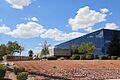
Delta Academy in North Las Vegas
See also
 In Spanish: North Las Vegas para niños
