Las Vegas Range facts for kids
Quick facts for kids Las Vegas Range |
|
|---|---|

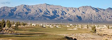
southern massif of Las Vegas Range
visible highpoint: Gass Peak, left-center |
|
| Highest point | |
| Peak | Gass Peak |
| Elevation | 6,943 ft (2,116 m) |
| Geography | |
| Country | United States |
| State | Nevada |
| District | Clark County |
| Settlement | North Las Vegas-(northern border) |
| Range coordinates | 36°34′16.882″N 115°2′11.026″W / 36.57135611°N 115.03639611°W |
| Topo map | USGS Hayford Peak SE |
The Las Vegas Range is a dry mountain range located in Clark County, Nevada. This range is found in the southeastern part of the Desert National Wildlife Refuge. It's a cool place to explore if you're interested in desert landscapes!
Contents
Geography of the Las Vegas Range
The Las Vegas Range stretches from north to south, featuring two main lines of peaks. The highest point in the range is called Gass Peak. You can find it in the southern part of the mountains, overlooking the Las Vegas Valley.
Southern Las Vegas Range
The southern part of the Las Vegas Range has straight ridgelines that end at a large group of mountains called a massif. This area helps to form the northern edge of the Las Vegas Valley metropolitan area. This includes the city of North Las Vegas.
Neighboring Mountain Ranges
The Las Vegas Range is located southeast of the Sheep Range. The Sheep Range is another very large mountain range that also runs from north to south. Both of these ranges were formed by a process called Basin and Range faulting. This means huge blocks of the Earth's crust moved up and down, creating mountains and valleys.
To the east of the Las Vegas Range, you'll find the Arrow Canyon Range, which also runs north to south. The U.S. Route 93 highway runs between these two ranges. It also follows the border of the Desert National Wildlife Refuge to the west.
See also
 In Spanish: Cordillera de Las Vegas para niños
 | Misty Copeland |
 | Raven Wilkinson |
 | Debra Austin |
 | Aesha Ash |


