
Sheep Range facts for kids
Quick facts for kids Sheep Range |
|
|---|---|

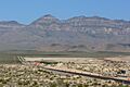
Sheep Range from Starvation Flat
|
|
| Highest point | |
| Peak | Hayford Peak |
| Elevation | 9,912 ft (3,021 m) |
| Geography | |

Location in Nevada
|
|
| Country | United States |
| Range coordinates | 36°48′29″N 115°07′43″W / 36.80806°N 115.12861°W |
The Sheep Range is a mountain range located in the United States. You can find it north of Las Vegas, Nevada. These mountains stretch across both Clark and Lincoln Counties. They are part of a special protected area called the Desert National Wildlife Refuge.
The highest point in the Sheep Range is Hayford Peak. This peak stands tall at 9,912 feet (about 3,021 meters) above sea level. The Sheep Range runs mostly in a north-south direction. It sits between the Las Vegas Range to its east and the Desert Range to its west.
Contents
What is the Sheep Range?
The Sheep Range is a long chain of mountains. It is located in the desert landscape of Nevada. The range gets its name from the wild mountain sheep that used to live there. These sheep are also known as bighorn sheep.
Where is the Sheep Range located?
The Sheep Range is in the southern part of Nevada. It is just north of the busy city of Las Vegas. The mountains are part of a large wildlife refuge. This refuge helps protect many desert animals and plants.
What is the Great Basin Divide?
The Great Basin Divide is an important line on the map. It shows where water flows in different directions. For example, water on one side of the divide flows into the Great Basin. Water on the other side flows somewhere else.
A part of this divide goes through the southern Sheep Range. This means some rain that falls on the mountains here will flow into the Great Basin. Other rain might flow towards the Las Vegas Valley.
Images for kids
-
Sheep Range from Starvation Flat
