
Gass Peak facts for kids
Quick facts for kids Gass Peak |
|
|---|---|

Gass Peak from Las Vegas
|
|
| Highest point | |
| Elevation | 6,937 ft (2,114 m) |
| Prominence | 2,043 ft (623 m) |
| Geography | |
| Location | Clark County, Nevada, U.S. |
| Parent range | Las Vegas Range |
| Topo map | USGS Gass Peak |
Gass Peak is a very tall mountain in Southern Nevada. It's the highest point in the Las Vegas Range, reaching 6,937 feet (about 2,114 meters) high! You can easily see it if you are north of the Las Vegas Valley, near the city of North Las Vegas. This mountain is about 20 miles (32 kilometers) north of Las Vegas. It's also part of the Desert National Wildlife Refuge, which is managed by the U.S. Fish & Wildlife Service. There's even a communications tower with solar panels right at the very top of Gass Peak.
How Did Gass Peak Get Its Name?
Gass Peak is named after a person! It got its name from Octavius Decatur Gass (1828–1924). He was one of the first people to settle in the Las Vegas area. He was also a well-known rancher there a long time ago.
Exploring Gass Peak
Gass Peak is open to the public, so people can visit it! The easiest way to get there is by taking Corn Creek Road off U.S. Route 95. This road is northwest of Las Vegas. From there, you'll go onto dirt roads called Mormon Well Road and Gass Peak Road.
There are places to camp and park your car along these roads and at the start of the trails. The hiking trails on Gass Peak are not kept up, so they can be a bit rough. From the top of the peak, you can see mountains far away. These mountains are in Nye County, Lincoln County, Utah, Arizona, and California.
Gallery
-
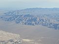
Gass Peak viewed from above
-
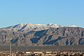
Gass Peak covered in snow
-
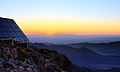
Sunrise viewed looking east atop Gass Peak
.jpg)


