Arrow Canyon Range facts for kids
Quick facts for kids Arrow Canyon Range |
|
|---|---|

|
|
| Highest point | |
| Elevation | 1,219 m (3,999 ft) |
| Geography | |
| Country | United States |
| State | Nevada |
| District | Clark County |
| Range coordinates | 36°40′24.888″N 114°51′46.003″W / 36.67358000°N 114.86277861°W |
| Topo map | USGS Arrow Canyon |
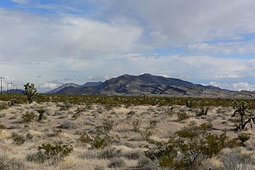
The Arrow Canyon Range is a small mountain range located in Clark County, Nevada, United States. It stretches from south to north. This range is part of the larger Basin and Range region. This area is known for its many parallel mountain ranges and valleys.
The mountains here were formed by "block faulting." This means large blocks of the Earth's crust moved up or down along cracks called faults.
Exploring the Arrow Canyon Range
The Arrow Canyon Range is about 25 miles long. It is roughly 7 miles wide. The lowest parts of the range are around 3,000 feet above sea level. The highest point reaches 4,953 feet.
Location and Views
The range runs right next to U.S. Route 93. This makes it easy to see the western side of the mountains from the road. It's only about 3.5 miles away from the highway.
Unique Rock Formations
Like many mountains in southern Nevada, the Arrow Canyon Range has bare, gray limestone rocks. These rocks are very common in this desert area. If you look closely, you can see a dark band of rock higher up on the mountains. This band is tilted and broken. It shows how much the Earth's crust moved and changed here long ago. This movement is called geologic activity.
 | Georgia Louise Harris Brown |
 | Julian Abele |
 | Norma Merrick Sklarek |
 | William Sidney Pittman |


