Kings Peak (Utah) facts for kids
Quick facts for kids Kings Peak |
|
|---|---|

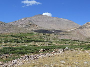
Kings Peak as viewed from the east in Painter Basin.
|
|
| Highest point | |
| Elevation | 13,528 ft (4,123 m) NAVD 88 |
| Prominence | 6,348 ft (1,935 m) |
| Listing |
|
| Naming | |
| Etymology | Clarence King |
| Geography | |
| Location | Duchesne County, Utah, U.S. |
| Parent range | Uinta Mountains |
| Topo map | USGS King's Peak |
| Climbing | |
| Easiest route | Hike |
Kings Peak is the tallest peak in the U.S. state of Utah. It stands at an amazing 13,528 feet (4,123 meters) high! This giant peak is found in the Uinta Mountains. It is a popular spot for hikers and adventurers.
Exploring Kings Peak
Kings Peak is located in northeastern Utah. It is part of the central Uinta Mountains. You can find it within the Ashley National Forest. The peak is also inside the High Uintas Wilderness. This means it is a protected natural area.
The mountain is about 79 miles (127 km) east of Salt Lake City. It is also about 45 miles (72 km) north of the town of Duchesne.
Climbing Kings Peak
There are three main ways to reach the top of Kings Peak. One way is to scramble up the east side. Another is to hike along the northern ridge. A third way is a longer but easier hike up the southern slope.
The mountain was named after Clarence King. He was a surveyor in the area. He also became the first director of the United States Geological Survey. The easiest path to the summit is a 29-mile (47 km) round trip hike.
 | Roy Wilkins |
 | John Lewis |
 | Linda Carol Brown |


