
Duchesne County, Utah facts for kids
Quick facts for kids
Duchesne County
|
||
|---|---|---|

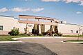
Duchesne County Courthouse in Duchesne
|
||
|
||

Location within the U.S. state of Utah
|
||
 Utah's location within the U.S. |
||
| Country | ||
| State | ||
| Founded | January 4, 1915 (proclaimed in effect) | |
| Named for | Duchesne River | |
| Seat | Duchesne | |
| Largest city | Roosevelt | |
| Area | ||
| • Total | 3,256 sq mi (8,430 km2) | |
| • Land | 3,241 sq mi (8,390 km2) | |
| • Water | 15 sq mi (40 km2) 0.50% | |
| Population
(2020)
|
||
| • Total | 19,596 | |
| • Density | 6.0184/sq mi (2.3237/km2) | |
| Time zone | UTC−7 (Mountain) | |
| • Summer (DST) | UTC−6 (MDT) | |
| Congressional district | 1st | |

Duchesne County (pronounced doo-SHAYN) is a county located in the northeast part of Utah. A county is like a smaller area within a state, often with its own local government. In 2020, about 19,596 people lived here. The main town where the county government is located is Duchesne. The biggest city in the county is Roosevelt.
Contents
History of Duchesne County
Much of Duchesne County was once part of the Uintah and Ouray Indian Reservation. This land was set aside in 1861 by US President Abraham Lincoln for the Uintah and White River Ute tribes. Later, other Ute tribes also moved to this area.
Around the year 1900, some of this reservation land was opened up for new settlers. These settlers were called "homesteaders." They could get 160 acres of land if they promised to farm it and live there for five years. After that, they would own the land. Unlike many other parts of Utah Territory, Duchesne County was mostly settled by these individual homesteaders, not by large groups from the LDS Church.
On July 13, 1914, people in Wasatch County voted to create a new county from its eastern part. The vote passed, and Duchesne County was officially formed on January 4, 1915. The county was named after its main town, Duchesne. The town itself was named after the Duchesne River. People believe fur trappers named the river in the 1820s after Mother Rose Philippine Duchesne, who started a school in Missouri. The county's borders have been the same since March 5, 1917.
Geography of Duchesne County
Duchesne County has a dry, rugged landscape with many rivers and streams. The Duchesne River flows through the middle of the county. The land generally slopes down towards the south and east. The county covers about 3,256 square miles. Most of this is land, with only a small part being water.
The northern part of the county is home to much of the Uinta Mountains. These mountains run from east to west. The highest natural point in all of Utah, Kings Peak, is located in Duchesne County. It stands at 13,528 feet (4,123 meters) tall!
Main Roads in Duchesne County
 US-40
US-40 US-191
- SR-35
- SR-87
- SR-121
 SR-150
- SR-208
Neighboring Counties
- Summit County - north
- Daggett County - northeast
- Uintah County - east
- Carbon County - south
- Utah County - southwest
- Wasatch County - west
Protected Natural Areas
- Ashley National Forest (part)
- Big Sand State Park
- Currant Creek Wildlife Management Area
- High Uintas Wilderness (part)
- Red Creek Wildlife Management Area
- Skitzy Wildlife Management Area
- Starvation State Park
- Wasatch-Cache National Forest (part)
Lakes and Reservoirs
- Big Sand Wash Reservoir
- Cedar View Reservoir
- Chepeta Lake
- Crater Lake
- Daynes Lake
- Grandaddy Lake
- Kidney Lake
- Lake Atwood
- Mirror Lake
- Moon Lake
- Starvation Reservoir
- Upper Stillwater Reservoir
Population of Duchesne County
| Historical population | |||
|---|---|---|---|
| Census | Pop. | %± | |
| 1920 | 9,093 | — | |
| 1930 | 8,263 | −9.1% | |
| 1940 | 8,958 | 8.4% | |
| 1950 | 8,134 | −9.2% | |
| 1960 | 7,179 | −11.7% | |
| 1970 | 7,299 | 1.7% | |
| 1980 | 12,565 | 72.1% | |
| 1990 | 12,645 | 0.6% | |
| 2000 | 14,371 | 13.6% | |
| 2010 | 18,607 | 29.5% | |
| 2020 | 19,596 | 5.3% | |
| US Decennial Census 1790–1960 1900–1990 1990–2000 2010 2020 |
|||
In 2020, Duchesne County had 19,596 people. The population density was about 6.1 people for every square mile. Most people living in the county were White (85.4%), with Native Americans making up 4.5% of the population. About 6.6% of the people were Hispanic or Latino.
The population was almost evenly split between males and females. The average age of people in the county was 33.3 years. About 32.3% of the population was under 18 years old. Most households were families, with many being married couples. The median income for a household was $61,655. This means half of the households earned more than this, and half earned less.
Communities in Duchesne County
Cities
Towns
Census-designated places
Unincorporated communities
These are smaller places that are not officially cities or towns.
- Altonah
- Arcadia
- Boneta
- Bridgeland
- Crescent
- Fruitland
- Hanna
- Hayden (part)
- Ioka
- Monarch
- Mount Emmons
- Mountain Home
- Stockmore
- Strawberry
- Talmage
- Upalco
- Utahn
Former communities
- Cedarview
- Harper
Education in Duchesne County
All schools in Duchesne County are part of the Duchesne School District.
Images for kids
-
Duchesne County Courthouse in Duchesne
See also
 In Spanish: Condado de Duchesne para niños
