Uinta Mountains facts for kids
Quick facts for kids Uinta Mountains |
|
|---|---|

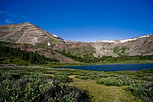
This view of Kings Peak and the Henry's Fork Basin shows the cliff bands and basins typical throughout the Uintas.
|
|
| Highest point | |
| Peak | Kings Peak |
| Elevation | 13,528 ft (4,123 m) |
| Geography | |
| Country | United States |
| Range coordinates | 40°46′N 110°35′W / 40.767°N 110.583°W |
| Parent range | Rocky Mountains |
| Geology | |
| Age of rock | Precambrian |
| Type of rock | quartzite, shale and slate |
The Uinta Mountains (yoo-IN-tə) are a mountain range in northeastern Utah that stretches a little into southern Wyoming in the United States. These mountains are part of the larger Rocky Mountains. They are special because they are the highest mountain range in the contiguous United States that runs from east to west.
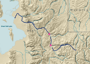
The Uinta Mountains are about 100 miles (160 km) east of Salt Lake City. Their peaks range from 11,000 to 13,528 feet (3,353 to 4,123 m) high. The very highest point is Kings Peak, which is also the highest point in Utah. The Mirror Lake Highway crosses the western part of the Uintas.
Contents
How the Uinta Mountains Were Formed
The Uinta Mountains were pushed up by powerful forces in the Earth during an event called the Laramide orogeny. This happened about 70 to 50 million years ago. The rocks in the middle of the Uintas are very old, between 700 and 800 million years old.
These rocks are mostly quartzite, slate, and shale. They were once sediments that settled in a large basin. Over time, they were buried deep and changed by heat and pressure. Many of the high peaks are made of these strong rocks.
The mountains have bands of cliffs that lead up to wide, flat tops. The Uintas are unusual because they run east to west, unlike most Rocky Mountain ranges. This might be due to how the land moved and twisted long ago.
Water in the Uintas
The Uinta Mountains are a very important source of water. Many rivers start here. The south and east sides of the range feed into the Colorado River system. Rivers like the Blacks Fork and the Duchesne River flow into the Green River. The Green River is a major part of the Colorado River.
On the west side of the Uintas, the Bear River and Weber River begin. These are the two biggest rivers that flow into Great Salt Lake. The Provo River also starts here and flows into Utah Lake.
The high parts of the Uintas get a lot of rain and snow, often more than 40 inches (100 cm) each year. The peaks are covered in snow for most of the year. The Uinta Mountains have over 400 miles (640 km) of streams and 1,000 lakes and ponds.
Animals and Plants of the Uintas

The Uinta Mountains are home to many different plants and animals. Most of the range is part of the Uinta-Wasatch-Cache National Forest and Ashley National Forest. The highest peaks are protected as the High Uintas Wilderness.
Trees and Plants
The forests here have many types of trees, including:
You can also find many kinds of grasses, shrubs, and wildflowers growing throughout the mountains.
Wildlife
The Uintas are full of amazing wildlife. Some of the large animals you might see include:
Predators that live here are:
Birds of prey, like Bald And Golden Eagles and various hawks and owls, also live in the Uintas. Other interesting birds include the Sage Grouse and White-tailed Ptarmigan.
Fun Places to Visit
The Uinta Mountains offer many cool places to explore:
- Camp Steiner: This is the highest Boy Scout camp in the United States, located at 10,400 feet (3,200 m). It's near mile marker 33 on the Mirror Lake Highway.
- Uinta Highline Trail: This long trail goes across the entire mountain range. It's a very popular trail for people who love backpacking.
- Dinosaur National Monument: This monument is located on the southeast side of the Uinta Mountains, right on the border between Colorado and Utah. It's famous for its dinosaur fossils.
See also
 In Spanish: Montañas Uinta para niños
 | Chris Smalls |
 | Fred Hampton |
 | Ralph Abernathy |


