Gilbert Peak (Utah) facts for kids
Quick facts for kids Gilbert Peak |
|
|---|---|

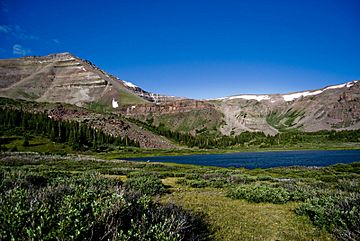
Gilbert Peak viewed from the northeast in the West Fork Beaver Creek drainage.
|
|
| Highest point | |
| Elevation | 13,448 ft (4,099 m) NAVD 88 |
| Prominence | 1,554 ft (474 m) |
| Geography | |
| Location | Duchesne County and Summit County, Utah, U.S. |
| Parent range | Uinta Mountains |
| Topo map | USGS Kings Peak |
Gilbert Peak is a very tall mountain in the state of Utah in the United States. It is the third highest peak in Utah. Its top reaches an elevation of 13,448 feet (4,099 m) above sea level.
About Gilbert Peak
Gilbert Peak is found in the middle of the Uinta Mountains. These mountains are a large range in northeastern Utah. The peak sits right on the border between two different areas. These areas are Summit County and Duchesne County.
Where is it located?
The mountain is part of two important national forests. These are the Uinta-Wasatch-Cache National Forest and the Ashley National Forest. National forests are special lands protected by the government. They are used for recreation and keeping nature safe.
Gilbert Peak is also the highest point in Summit County. It is located inside the High Uintas Wilderness. A wilderness area is a place where nature is kept wild. There are very few roads or buildings there. This helps protect the plants and animals that live there.
 | Selma Burke |
 | Pauline Powell Burns |
 | Frederick J. Brown |
 | Robert Blackburn |


