
Bear River (Great Salt Lake) facts for kids
Quick facts for kids Bear River |
|
|---|---|

Bear River Canyon in Utah c. 1869
|
|

Map of the Bear River watershed.
|
|
| Country | United States |
| State | Utah, Idaho, Wyoming |
| Physical characteristics | |
| Main source | Confluence of Hayden Fork and Stillwater Fork Uinta Mountains, Summit County, Utah 8,510 ft (2,590 m) 40°52′2″N 110°50′9″W / 40.86722°N 110.83583°W |
| River mouth | Great Salt Lake, Box Elder County, Utah 4,211 ft (1,284 m) 41°27′30″N 112°17′25″W / 41.45833°N 112.29028°W |
| Length | 350 mi (560 km) |
| Basin features | |
| Basin size | 7,026 sq mi (18,200 km2) |
The Bear River is a very important river in the western United States. It is the biggest river that flows into the Great Salt Lake. This river helps drain water from mountains and farms in Wyoming, Idaho, and Utah.
The Bear River is about 350 miles (560 km) long. What makes it special is that it's the longest river in North America that doesn't eventually flow into the ocean! Instead, it ends in the salty waters of the Great Salt Lake.
Contents
Where Does the Bear River Flow?
The Bear River starts in northeastern Utah. It begins high up in the Uinta Mountains from two smaller streams called Hayden Fork and Stillwater Fork. These streams come from very high places, like Middle Basin, which is about 10,000 feet (3,000 m) high.
From its source, the river flows north. It goes through the southwest part of Wyoming, passing by the town of Evanston. Then, it weaves along the border between Utah and Wyoming.
A Big U-Turn in Idaho
The river then turns northwest into Idaho. It flows through the Bear Lake Valley, past Montpelier. Here, it gets water from Bear Lake through a short canal.
Near Soda Springs, the Bear River makes a sharp turn. It suddenly changes direction and flows south. This big U-turn happens because of ancient lava flows. Long ago, the river used to flow into the Snake River. But lava blocked its path, forcing it to turn south and eventually flow into what was then Lake Bonneville (which later became the Great Salt Lake).
Journey Through Utah
After its big turn, the Bear River flows south through the wide Cache Valley. It passes towns like Preston in Idaho and Cornish and Newton when it re-enters Utah.
The river is held back by a dam to form the Cutler Reservoir. Here, another river, the Little Bear River, joins it. Finally, the Bear River flows into the mud flats of the Great Salt Lake. This is about 10 miles (16 km) southwest of Brigham City.
How People Use the Bear River
The Bear River is very important for the people living in its valley.
Water for Farms
Farmers use a lot of the river's water for irrigation. This means they use canals and ditches to bring water from the river to their crops. This helps grow food in the dry farming valleys of Idaho and Utah.
Home for Birds
The last 10 miles (16 km) of the river, where it meets the Great Salt Lake, is a special place. It's protected as the Bear River Migratory Bird Refuge. This refuge is a safe home for many different kinds of birds that migrate (travel long distances) each year.
A Look at Bear River History
The Bear River valley has a rich history, with many different groups of people living there over time.
Early Inhabitants
For a long time, the Shoshone people lived in the Bear River valley. They hunted, fished, and gathered food there.
Explorers and Pioneers
In the early 1800s, fur trappers started exploring the area. Later, famous explorers like John C. Frémont visited in 1843.
The Mormon Trail, a path used by pioneers, crossed the Bear River. Other important trails, like the California Trail and Oregon Trail, followed the Bear River north into Idaho. Some travelers decided to stay and build new lives in the Bear River Valleys.
The Bear River Massacre
In 1863, a sad event happened in the Cache Valley. Soldiers from the United States Army attacked a Shoshone winter village. Many Shoshone people were killed in what is now known as the Bear River Massacre.
Farming and Industry Grow
After the Transcontinental Railroad was finished in 1869, land in the Bear River Valley became valuable. Companies bought large areas of land to develop farms and irrigation systems.
One important company was the Corinne Mill, Canal and Stock Company. They built dams and canals to bring water to the land. This helped more farms grow.
The Rise of Sugar Beets
Farmers in the Bear River Valley started to grow sugar beets. These plants are used to make sugar. This crop was very successful.
The Utah Sugar Company became very interested in the area. They bought land and water rights to grow even more sugar beets. Between 1902 and 1905, they expanded canals and even built a power plant on the Bear River. They also helped build a railroad to transport the sugar beets to a new processing factory in Garland.
Over time, parts of these companies were bought by others. For example, Utah Power & Light (now Rocky Mountain Power) bought the water rights and power plant. This shows how the Bear River has been important for farming, power, and the growth of communities in the region.
Images for kids
-
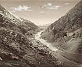
Bear River Canyon in Utah around 1869
-
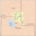
Map of the Bear River watershed
See also
 In Spanish: Río del Oso (Utah) para niños
