
Duchesne River facts for kids
Quick facts for kids Duchesne River |
|
|---|---|
|
|

Map of the Duchesne River watershed
|
|
| Other name(s) | Euwinty |
| Country | United States |
| State | Utah |
| Cities | Duchesne, Tabiona, Myton, Randlett, Hanna |
| Physical characteristics | |
| Main source | Uinta Mountains Duchesne County, Utah 10,093 ft (3,076 m) 40°42′31″N 110°52′25″W / 40.70861°N 110.87361°W |
| River mouth | Green River Uintah County, Utah 4,652 ft (1,418 m) 40°05′08″N 109°40′45″W / 40.08556°N 109.67917°W |
| Length | 115 mi (185 km) |
| Basin features | |
| Basin size | 3,790 sq mi (9,800 km2) |
| Tributaries |
|
The Duchesne River (pronounced doo-SHAYN) flows through the Uinta Basin in Utah, United States. It is a major branch of the Green River. The river's watershed, which is the area of land that drains into it, covers the northeastern part of Utah. The Duchesne River is about 115 miles (185 km) long. It drains a large area of land, covering about 3,790 square miles (9,800 km2).
Contents
Where Does the Duchesne River Flow?
The Duchesne River starts high up in the Uinta Mountains in northern Utah. From there, it flows mostly southeast.
Key River Turns and Connections
- Joining the Strawberry River: The Duchesne River turns east where the Strawberry River joins it from the west.
- Meeting the Lake Fork and Uinta Rivers: It picks up the Lake Fork River from the north near Myton. Further downstream, the Uinta River also joins it from the north near Randlett.
- Flowing into the Green River: After Randlett, the Duchesne River turns southeast. It finally empties into the Green River near Ouray.
Counties and Other Tributaries
The main part of the Duchesne River flows through Duchesne and Uintah counties. However, some of its watershed reaches into Wasatch County. Other important rivers that feed into the Duchesne system include:
- The Yellowstone River, which is a big branch of the Lake Fork.
- The Whiterocks River, which flows into the Uinta River.
- Rock Creek, joining the Duchesne River southwest of Talmage.
- Currant Creek, a branch of the Strawberry River.
History of the Duchesne River's Name

The Duchesne River has a long history, especially with its name.
Early Explorers and Trappers
In September 1776, the Domínguez–Escalante expedition named the river Santa Caterina de Sena. Later, French American trappers gave it the name "Duchesne." These trappers came from St. Louis, Missouri, and worked out of Taos, New Mexico. They followed the Old Spanish Trail to reach the Uinta Basin.
From 1824 to 1840, the river and its smaller streams were important for the fur trade. Trappers collected many beaver pelts here, which were used to make hats. In 1825, William Henry Ashley explored the area and called this branch of the Green River the "Euwinty" river. The name "Duchesne Fork" first appeared on a map by Warren A Ferris in 1835.
Changing Names on Maps
A map made by John C. Frémont in 1842 called the main river the Uintah River. The northern fork, where the town of Duchesne is now, was labeled "Duchesne Fork." The main river continued to be called the Uintah River until the 1860s. Even a US Army engineer, Captain Simpson, referred to it as "Des Chesney's fork of the Uinta river."
What Does "Duchesne" Mean?
The exact reason for the name "Duchesne" is not fully known. It is believed that French trappers, possibly as early as 1808, named it. Some ideas for the name's origin include:
- Mother Rose Philippine Duchesne, who founded a school near St. Louis, Missouri.
- The Ute word "doo-shane," which means "dark canyon."
- André Duchesne, a French historian.
- A French trapper named Du Chasne.
- The French phrase "Du chesne," meaning "of the oak (tree)."
How Humans Use the Duchesne River

Most of the water in the Duchesne River comes from melting snow in the Uinta Mountains.
Water Diversions and Flow
The U.S. Bureau of Reclamation tracks the river's flow. On average, between 1906 and 2014, the river had about 787,000 acre-feet (971,000,000 m3) of water each year. However, a lot of this water is used by people. It is diverted for irrigation to water crops. It is also sent through the Central Utah Project to provide water for Salt Lake City and the surrounding areas, which is Utah's largest population center. This reduces the river's flow at its mouth to about 378,000 acre-feet (466,000,000 m3) in an average year.
During very wet years, especially in late spring and early summer, the Duchesne River can become a powerful, fast-flowing river. It can carry many thousands of cubic feet of water every second.
Dams on the River System
Several dams have been built on the Duchesne River and its branches to help manage the water:
- Moon Lake Dam: This dam was built in 1938 on the Lake Fork of the Duchesne River.
- Starvation Dam and Soldier Creek Dam: These dams are located on the Strawberry River. The Strawberry River is the longest branch that flows into the Duchesne River.
Images for kids
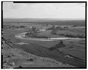
-

The Duchesne River near Duchesne, Utah
-
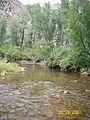
Headwaters of the Duchesne River
-
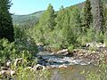
North Fork of Duchesne Canyon
