Hanna, Utah facts for kids
Quick facts for kids
Hanna, Utah
|
|
|---|---|
| Country | United States |
| State | Utah |
| County | Duchesne |
| Named for | William P. Hanna |
| Elevation | 6,765 ft (2,062 m) |
| Time zone | UTC-7 (Mountain (MST)) |
| • Summer (DST) | UTC-6 (MDT) |
| ZIP codes |
84031
|
| GNIS feature ID | 1428509 |
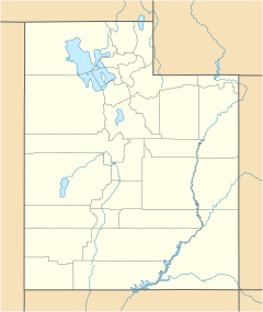
Hanna is a small, quiet community located in Duchesne County, Utah. It's not a city with its own government, but rather an "unincorporated community." This means it's a group of homes and businesses that are part of the larger county. Hanna is also special because it's located within the Uintah and Ouray Indian Reservation.
About Hanna
Hanna is found along State Route 35 and the Duchesne River. It's about 5 miles (8 km) northwest of Tabiona. It's also about 25 miles (40 km) northwest of Duchesne, which is the main town for Duchesne County. Hanna sits at a high elevation of about 6,765 feet (2,062 meters) above sea level.
Even though Hanna isn't a city, it has its own ZIP code, which is 84031. For many years, it even had its own post office. The community was named after its first postmaster, William P. Hanna.
You might sometimes see the name Defas Park on old maps where Hanna is located. Defas Park was a popular resort in Hanna that had a dance hall and cabins. The name Hanna used to appear on maps for a spot a bit further west. However, the post office that was once located along State Route 35 was actually about 3.5 miles (5.6 km) northwest of the main community area.
Hanna's Weather
Hanna experiences a type of weather known as a humid continental climate. This means the area has big changes in temperature throughout the year. Summers are usually warm to hot, and sometimes humid. Winters are cold, and can even be very cold. This climate is often shown as "Dfb" on climate maps.
 | Ernest Everett Just |
 | Mary Jackson |
 | Emmett Chappelle |
 | Marie Maynard Daly |


